Ortaffa
Ortaffa (Catalan: Hortafà) is a commune in the Pyrénées-Orientales department in southern France.
Ortaffa Hortafà | |
|---|---|
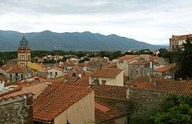 General view of the village. | |
 Coat of arms | |
Location of Ortaffa 
| |
 Ortaffa  Ortaffa | |
| Coordinates: 42°34′51″N 2°55′33″E | |
| Country | France |
| Region | Occitanie |
| Department | Pyrénées-Orientales |
| Arrondissement | Céret |
| Canton | La Plaine d'Illibéris |
| Intercommunality | secteur d'Illibéris |
| Government | |
| • Mayor (2001–2008) | Raymond Pla |
| Area 1 | 8.49 km2 (3.28 sq mi) |
| Population (2017-01-01)[1] | 1,481 |
| • Density | 170/km2 (450/sq mi) |
| Time zone | UTC+01:00 (CET) |
| • Summer (DST) | UTC+02:00 (CEST) |
| INSEE/Postal code | 66129 /66560 |
| Elevation | 19–90 m (62–295 ft) (avg. 44 m or 144 ft) |
| 1 French Land Register data, which excludes lakes, ponds, glaciers > 1 km2 (0.386 sq mi or 247 acres) and river estuaries. | |
Geography
Ortaffa is located in the canton of La Plaine d'Illibéris and in the arrondissement of Perpignan.
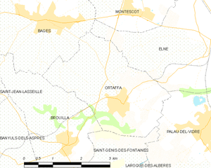
Map of Ortaffa and its surrounding communes
Population
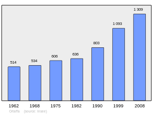
Population 1962-2008
gollark: As you know, worms can travel through time.
gollark: Wormholes, obviously.
gollark: The insulator in PCBs probably isn't perfect, so if your voltage is high enough things will be shorted together.
gollark: Solution: cause nonlinearities.
gollark: * series
References
- "Populations légales 2017". INSEE. Retrieved 6 January 2020.
| Wikimedia Commons has media related to Ortaffa. |
| Authority control |
|
|---|
This article is issued from Wikipedia. The text is licensed under Creative Commons - Attribution - Sharealike. Additional terms may apply for the media files.