Saint-Michel-de-Llotes
Saint-Michel-de-Llotes (French: [sɛ̃.miʃɛl.də.jɔt] (![]()
Saint-Michel-de-Llotes Sant Miquel de Llotes | |
|---|---|
.jpg) The town hall in Saint-Michel-de-Llotes | |
Location of Saint-Michel-de-Llotes 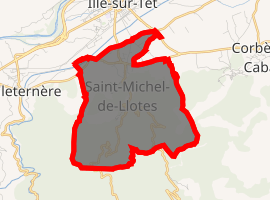
| |
 Saint-Michel-de-Llotes  Saint-Michel-de-Llotes | |
| Coordinates: 42°39′00″N 2°37′29″E | |
| Country | France |
| Region | Occitanie |
| Department | Pyrénées-Orientales |
| Arrondissement | Prades |
| Canton | Le Canigou |
| Intercommunality | Roussillon Conflent |
| Government | |
| • Mayor (2020–2026) | Jean-Claude Solere |
| Area 1 | 8.64 km2 (3.34 sq mi) |
| Population (2017-01-01)[1] | 348 |
| • Density | 40/km2 (100/sq mi) |
| Time zone | UTC+01:00 (CET) |
| • Summer (DST) | UTC+02:00 (CEST) |
| INSEE/Postal code | 66185 /66130 |
| Elevation | 146–602 m (479–1,975 ft) (avg. 187 m or 614 ft) |
| 1 French Land Register data, which excludes lakes, ponds, glaciers > 1 km2 (0.386 sq mi or 247 acres) and river estuaries. | |
Geography
Saint-Michel-de-Llotes is located in the canton of Le Canigou and in the arrondissement of Prades.
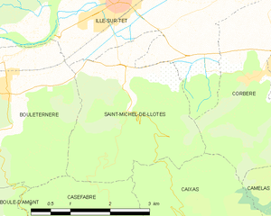
Map of Saint-Michel-de-Llotes and its surrounding communes
Population
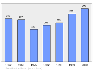
Population 1962-2008
gollark: Indeed.
gollark: I, traitorously, use fancy GUI stuff like Budgie, VS Code and `nano` when I need to edit config files or whatever.
gollark: This is ridiculous.
gollark: Or types of kinds or whatever.
gollark: What are kinds of kinds called?
References
- "Populations légales 2017". INSEE. Retrieved 6 January 2020.
| Wikimedia Commons has media related to Saint-Michel-de-Llotes. |
| Authority control |
|
|---|
This article is issued from Wikipedia. The text is licensed under Creative Commons - Attribution - Sharealike. Additional terms may apply for the media files.