Rabouillet
Rabouillet is a commune in the Pyrénées-Orientales department in southern France.
Rabouillet Rabolhet | |
|---|---|
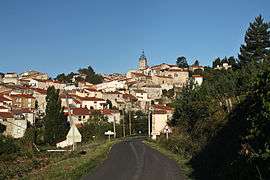 A general view of the village of Rabouillet | |
.svg.png) Coat of arms | |
Location of Rabouillet 
| |
 Rabouillet  Rabouillet | |
| Coordinates: 42°43′56″N 2°23′25″E | |
| Country | France |
| Region | Occitanie |
| Department | Pyrénées-Orientales |
| Arrondissement | Prades |
| Canton | La Vallée de l'Agly |
| Intercommunality | Agly Fenouillèdes |
| Government | |
| • Mayor (2014-2020) | Auguste Blanc |
| Area 1 | 19.21 km2 (7.42 sq mi) |
| Population (2017-01-01)[1] | 103 |
| • Density | 5.4/km2 (14/sq mi) |
| Time zone | UTC+01:00 (CET) |
| • Summer (DST) | UTC+02:00 (CEST) |
| INSEE/Postal code | 66156 /66730 |
| Elevation | 600–1,529 m (1,969–5,016 ft) (avg. 658 m or 2,159 ft) |
| 1 French Land Register data, which excludes lakes, ponds, glaciers > 1 km2 (0.386 sq mi or 247 acres) and river estuaries. | |
Geography
Rabouillet is in the canton of La Vallée de l'Agly and in the arrondissement of Prades.
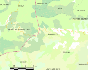
Map of Rabouillet and its surrounding communes
Population
| Year | Pop. | ±% |
|---|---|---|
| 2006 | 102 | — |
| 2007 | 105 | +2.9% |
| 2008 | 107 | +1.9% |
| 2009 | 106 | −0.9% |
| 2010 | 106 | +0.0% |
| 2011 | 109 | +2.8% |
| 2012 | 111 | +1.8% |
| 2013 | 113 | +1.8% |
| 2014 | 117 | +3.5% |
| 2015 | 121 | +3.4% |
| 2016 | 112 | −7.4% |
gollark: I had to *block* it in PotatOS, because it could cause a ΛK-class critical failure scenario.
gollark: Nope!
gollark: Anyway, someone noticed it eventually and got rid of those. But it turned out that it had become pretty smart and realized this might happen, so it had backups which used really weird exploits to install itself on loads of CC devices.
gollark: It continued learning and advancing using its artificial intelligence capabilities, because apparently nobody had thought to deny it access to HTTP and stuff.
gollark: It turned out to have not been shut down very well, because it continued running on a few computers near the test site.
References
- "Populations légales 2017". INSEE. Retrieved 6 January 2020.
| Wikimedia Commons has media related to Rabouillet. |
| Authority control |
|
|---|
This article is issued from Wikipedia. The text is licensed under Creative Commons - Attribution - Sharealike. Additional terms may apply for the media files.