Conat
Conat is a commune in the Pyrénées-Orientales department in southern France.
Conat | |
|---|---|
The church of Sainte-Marguerite of Nabilles, and surrounding buildings, in Conat | |
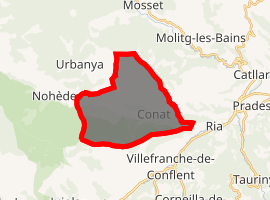
Location of Conat 
| |
 Conat  Conat | |
| Coordinates: 42°36′51″N 2°21′27″E | |
| Country | France |
| Region | Occitanie |
| Department | Pyrénées-Orientales |
| Arrondissement | Prades |
| Canton | Les Pyrénées catalanes |
| Intercommunality | Conflent |
| Government | |
| • Mayor (2014–2020) | Pascal Espeut |
| Area 1 | 19.12 km2 (7.38 sq mi) |
| Population (2017-01-01)[1] | 61 |
| • Density | 3.2/km2 (8.3/sq mi) |
| Time zone | UTC+01:00 (CET) |
| • Summer (DST) | UTC+02:00 (CEST) |
| INSEE/Postal code | 66054 /66500 |
| Elevation | 467–1,680 m (1,532–5,512 ft) (avg. 530 m or 1,740 ft) |
| 1 French Land Register data, which excludes lakes, ponds, glaciers > 1 km2 (0.386 sq mi or 247 acres) and river estuaries. | |
Geography
Localisation
Conat is located in the canton of Les Pyrénées catalanes and in the arrondissement of Prades.

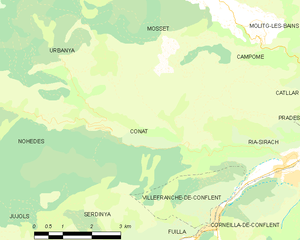
Map of Conat and its surrounding communes
Neighbouring communes
Population

Population 1962-2008
gollark: Otherwise it'll reencode everything and it'll be slow and lossy.
gollark: You should put in -c copy too.
gollark: You might have to use map otherwise.
gollark: If it only has an audio stream I don't believe ffmpeg cares.
gollark: ffmpeg -i thing -i thing thing
References
- "Populations légales 2017". INSEE. Retrieved 6 January 2020.
| Wikimedia Commons has media related to Conat. |
This article is issued from Wikipedia. The text is licensed under Creative Commons - Attribution - Sharealike. Additional terms may apply for the media files.
