Ansignan
Ansignan is a commune in the Pyrénées-Orientales département in southern France.
Ansignan | |
|---|---|
The main road in Ansignan | |
 Coat of arms | |
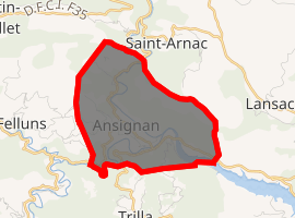
Location of Ansignan 
| |
 Ansignan  Ansignan | |
| Coordinates: 42°45′43″N 2°30′59″E | |
| Country | France |
| Region | Occitanie |
| Department | Pyrénées-Orientales |
| Arrondissement | Prades |
| Canton | La Vallée de l'Agly |
| Intercommunality | Communauté de communes Agly Fenouillèdes |
| Government | |
| • Mayor (2014-2020) | Jean-Pierre Pilart |
| Area 1 | 7.84 km2 (3.03 sq mi) |
| Population (2017-01-01)[1] | 166 |
| • Density | 21/km2 (55/sq mi) |
| Time zone | UTC+01:00 (CET) |
| • Summer (DST) | UTC+02:00 (CEST) |
| INSEE/Postal code | 66006 /66220 |
| Elevation | 155–583 m (509–1,913 ft) (avg. 235 m or 771 ft) |
| 1 French Land Register data, which excludes lakes, ponds, glaciers > 1 km2 (0.386 sq mi or 247 acres) and river estuaries. | |

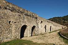
Roman Aqueduct of Ansignan
Geography
Localisation
Ansignan is located in the canton of La Vallée de l'Agly and in the arrondissement of Perpignan.

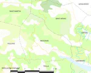
Map of Ansignan and its surrounding communes
Neighbouring communes
Government and politics

Seal of Ansignan in 1815
Communal administration
The town council of Ansignan is composed in 2014 of eleven councilors : seven men (the mayor, two deputy mayors and four councilors) and four women (four councilors).[2]
Mayors

Signature of mayor Joseph Grand (Jr.) in 1815
| Mayor | Term start | Term end |
|---|---|---|
| Joseph Grand | 1792 | 1795 |
| Pierre Grand | 1795 | 1799 |
| Marc Babulet | 1799 | 1801 |
| Joseph Grand | 1801 | 1813 |
| Joseph Grand Jr.[3] | 1813 | 1815 |
| Jean Raspaud[3] | 1815 | 1816 |
| Pierre Barbaza | 1816 | 1835 |
| Jacques Gandou | 1835 | 1841 |
| Jean-BaptisteFage | 1841 | 1846 |
| Joseph Pratx | 1846 | 1850 |
| Saturnin Carol | 1850 | 1850 |
| Joseph Merou | 1850 | 1850 |
| Pierre Estève | 1850 | 1851 |
| Joseph Barbaza | 1851 | 1852 |
| Pierre Estève | 1852 | 1856 |
| François Bascou | 1856 | 1865 |
| Pierre Vaysse | 1865 | 1876 |
| JosephBarbaza | 1876 | 1884 |
| André Gelly | 1884 | 1888 |
| Jean-François Dauliac | 1888 | 1895 |
| Pierre Pech | 1895 | 1908 |
| Célestin Calvet | 1908 | 1912 |
| Jacques-Louis Pech | 1912 | 1929 |
| Etienne Bascou | 1935 | 1977 |
| Guy Barbaza | 1977 | 1999 |
| Guy Audouy | 1999 | 2001 |
| Mauricette Pelissier | 2001 | 2014 |
| Jean-Pierre Pilart | 2014 |
Population
| Year | Pop. | ±% |
|---|---|---|
| 1794 | 221 | — |
| 1800 | 248 | +12.2% |
| 1806 | 276 | +11.3% |
| 1820 | 277 | +0.4% |
| 1831 | 317 | +14.4% |
| 1836 | 306 | −3.5% |
| 1841 | 307 | +0.3% |
| 1846 | 288 | −6.2% |
| 1851 | 301 | +4.5% |
| 1856 | 271 | −10.0% |
| 1861 | 287 | +5.9% |
| 1866 | 293 | +2.1% |
| 1872 | 295 | +0.7% |
| 1876 | 273 | −7.5% |
| 1881 | 276 | +1.1% |
| 1886 | 281 | +1.8% |
| 1891 | 289 | +2.8% |
| 1896 | 274 | −5.2% |
| 1901 | 300 | +9.5% |
| 1906 | 278 | −7.3% |
| 1911 | 248 | −10.8% |
| 1921 | 252 | +1.6% |
| 1926 | 246 | −2.4% |
| 1931 | 268 | +8.9% |
| 1936 | 263 | −1.9% |
| 1946 | 245 | −6.8% |
| 1954 | 229 | −6.5% |
| 1962 | 225 | −1.7% |
| 1968 | 259 | +15.1% |
| 1975 | 225 | −13.1% |
| 1982 | 194 | −13.8% |
| 1990 | 212 | +9.3% |
| 1999 | 198 | −6.6% |
| 2006 | 186 | −6.1% |
| 2009 | 190 | +2.2% |
gollark: I have a great algorithm this round, actually.
gollark: Ah yes, you're right. I always get confused like this reading my own code ages after I write it.
gollark: If I was confused like that it would only be between ones I wrote, and I only wrote 16.2 of them.
gollark: I think you're wrong.
gollark: Did I now.
References
- "Populations légales 2017". INSEE. Retrieved 6 January 2020.
- The city council of Ansignan on the town official site Archived 2016-01-30 at the Wayback Machine
- (in French) Fabricio Cardenas, Vieux papiers des Pyrénées-Orientales, Ansignan, 18 juin 1815, January 11, 2014
| Wikimedia Commons has media related to Ansignan. |
This article is issued from Wikipedia. The text is licensed under Creative Commons - Attribution - Sharealike. Additional terms may apply for the media files.
