Égat
Égat (Catalan: Èguet) is a commune in the Pyrénées-Orientales department in southern France.
Égat Èguet | |
|---|---|
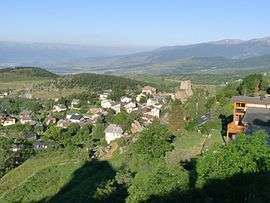 A general view of the village of Égat | |
Location of Égat 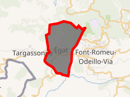
| |
 Égat  Égat | |
| Coordinates: 42°30′04″N 2°01′01″E | |
| Country | France |
| Region | Occitanie |
| Department | Pyrénées-Orientales |
| Arrondissement | Prades |
| Canton | Les Pyrénées catalanes |
| Intercommunality | Pyrénées Cerdagne |
| Government | |
| • Mayor (2014-2020) | Grégoire Vallbona |
| Area 1 | 4.47 km2 (1.73 sq mi) |
| Population (2017-01-01)[1] | 438 |
| • Density | 98/km2 (250/sq mi) |
| Time zone | UTC+01:00 (CET) |
| • Summer (DST) | UTC+02:00 (CEST) |
| INSEE/Postal code | 66064 /66120 |
| Elevation | 1,320–1,962 m (4,331–6,437 ft) (avg. 1,800 m or 5,900 ft) |
| 1 French Land Register data, which excludes lakes, ponds, glaciers > 1 km2 (0.386 sq mi or 247 acres) and river estuaries. | |
Geography
Localisation
Égat is located in the canton of Les Pyrénées catalanes and in the arrondissement of Prades.
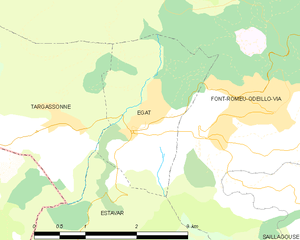
Map of Égat and its surrounding communes
Neighbouring communes
Places adjacent to Égat | |
|---|---|

Population
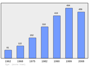
Population 1962-2008
gollark: Why induction smelt *to ingots*?
gollark: * from
gollark: * fronmm
gollark: I have my ME system configured with a few pulverizer recipes for stuff I actually need dusts for,]
gollark: ?
References
- "Populations légales 2017". INSEE. Retrieved 6 January 2020.
| Wikimedia Commons has media related to Égat. |
| Authority control |
|
|---|
This article is issued from Wikipedia. The text is licensed under Creative Commons - Attribution - Sharealike. Additional terms may apply for the media files.