Tarerach
Tarerach (Catalan: Tarerac) is a commune in the Pyrénées-Orientales department in southern France.
Tarerach Tarerac | |
|---|---|
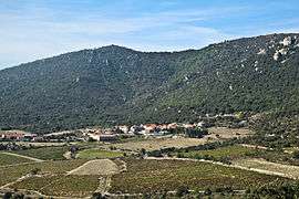 A general view of Tarerach | |
Location of Tarerach 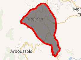
| |
 Tarerach  Tarerach | |
| Coordinates: 42°41′29″N 2°30′06″E | |
| Country | France |
| Region | Occitanie |
| Department | Pyrénées-Orientales |
| Arrondissement | Prades |
| Canton | La Vallée de l'Agly |
| Intercommunality | Communauté de communes Vinça Canigou |
| Government | |
| • Mayor (2014–2020) | Jean-Louis Salies |
| Area 1 | 8.16 km2 (3.15 sq mi) |
| Population (2017-01-01)[1] | 46 |
| • Density | 5.6/km2 (15/sq mi) |
| Time zone | UTC+01:00 (CET) |
| • Summer (DST) | UTC+02:00 (CEST) |
| INSEE/Postal code | 66201 /66320 |
| Elevation | 354–863 m (1,161–2,831 ft) (avg. 360 m or 1,180 ft) |
| 1 French Land Register data, which excludes lakes, ponds, glaciers > 1 km2 (0.386 sq mi or 247 acres) and river estuaries. | |
Geography
Tarerach is located in the canton of La Vallée de l'Agly and in the arrondissement of Prades.
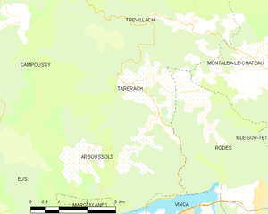
Map of Tarerach and its surrounding communes
Population
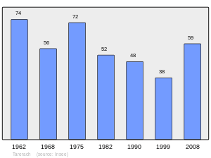
Population 1962-2008
gollark: Fortunately, ABR is safe, for now.
gollark: ++magic py len(bot.guilds)
gollark: FEAR chapter titles.
gollark: It says 7500 there.
gollark: Not that this is apparently hugely effective.
References
- "Populations légales 2017". INSEE. Retrieved 6 January 2020.
| Wikimedia Commons has media related to Tarerach. |
| Authority control |
|
|---|
This article is issued from Wikipedia. The text is licensed under Creative Commons - Attribution - Sharealike. Additional terms may apply for the media files.