Sentelie
Sentelie is a commune in the Somme department in Hauts-de-France in northern France.
Sentelie | |
|---|---|
The church in Sentelie | |
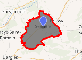
Location of Sentelie 
| |
 Sentelie  Sentelie | |
| Coordinates: 49°43′30″N 2°01′39″E | |
| Country | France |
| Region | Hauts-de-France |
| Department | Somme |
| Arrondissement | Amiens |
| Canton | Ailly-sur-Noye |
| Intercommunality | CC Somme Sud-Ouest |
| Government | |
| • Mayor (2008–2014) | Patrick Magnier |
| Area 1 | 5.53 km2 (2.14 sq mi) |
| Population (2017-01-01)[1] | 208 |
| • Density | 38/km2 (97/sq mi) |
| Time zone | UTC+01:00 (CET) |
| • Summer (DST) | UTC+02:00 (CEST) |
| INSEE/Postal code | 80734 /80160 |
| Elevation | 122–187 m (400–614 ft) (avg. 182 m or 597 ft) |
| 1 French Land Register data, which excludes lakes, ponds, glaciers > 1 km2 (0.386 sq mi or 247 acres) and river estuaries. | |
Geography
Sentelie is situated 16 miles (26 km) southwest of Amiens, on the D138 road
Population
| 1962 | 1968 | 1975 | 1982 | 1990 | 1999 | 2006 |
|---|---|---|---|---|---|---|
| 182 | 210 | 196 | 176 | 190 | 215 | 215 |
| Starting in 1962: Population without duplicates | ||||||
Places of interest
- The 15th / sixteenth century church of Saint Nicolas.
- The fifteenth century chapel of Saint Lambert, once a place of pilgrimage.
gollark: Yes. I know since you have test.
gollark: Ah. You do NOT have April Folly.
gollark: Meh, rounding errors.
gollark: Well in that case you would have more than 104.7 points.
gollark: The one for an attempted XSS attack?
See also
References
- "Populations légales 2017". INSEE. Retrieved 6 January 2020.
| Wikimedia Commons has media related to Sentelie. |
This article is issued from Wikipedia. The text is licensed under Creative Commons - Attribution - Sharealike. Additional terms may apply for the media files.