Y, Somme
Y (pronounced [i]) is a commune in the Somme department in Hauts-de-France in northern France.
Y | |
|---|---|
 | |
 Coat of arms | |
Location of Y 
| |
 Y  Y | |
| Coordinates: 49°48′14″N 2°59′34″E | |
| Country | France |
| Region | Hauts-de-France |
| Department | Somme |
| Arrondissement | Péronne |
| Canton | Ham |
| Intercommunality | Est de la Somme |
| Government | |
| • Mayor (2020-2026) | Vincent Joly |
| Area 1 | 2.73 km2 (1.05 sq mi) |
| Population (2017-01-01)[1] | 92 |
| • Density | 34/km2 (87/sq mi) |
| Demonym(s) | Ypsilonien(ne) |
| Time zone | UTC+01:00 (CET) |
| • Summer (DST) | UTC+02:00 (CEST) |
| INSEE/Postal code | 80829 /80190 |
| Elevation | 56–82 m (184–269 ft) (avg. 72 m or 236 ft) |
| 1 French Land Register data, which excludes lakes, ponds, glaciers > 1 km2 (0.386 sq mi or 247 acres) and river estuaries. | |
_church_(flickruser1banaan).jpg)
Y's church.
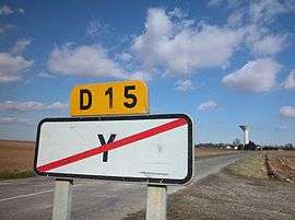
Y bears the shortest place name in France, and one of the shortest in the world.[2] The inhabitants call themselves Ypsilonien(ne)s, from the Greek letter Upsilon, which looks like the letter Y.
Geography
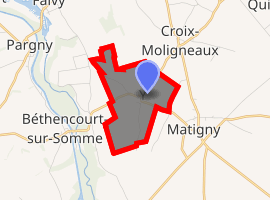
Y is situated 50 kilometres (30 miles) east of Amiens, at the junction of the D15 and D615 roads, in the far eastern side of the department.
Population
| Year | Pop. | ±% |
|---|---|---|
| 2006 | 81 | — |
| 2007 | 80 | −1.2% |
| 2008 | 81 | +1.2% |
| 2009 | 81 | +0.0% |
| 2010 | 85 | +4.9% |
| 2011 | 89 | +4.7% |
| 2012 | 93 | +4.5% |
| 2013 | 94 | +1.1% |
| 2014 | 94 | +0.0% |
| 2015 | 93 | −1.1% |
| 2016 | 93 | +0.0% |
gollark: Ask the entire esolangs discord server.
gollark: You *can* program in lambda calculus.
gollark: Yes it is.
gollark: Or probably some even more insane model than that.
gollark: No, the extreme of it is lambda calculus.
See also
References
- "Populations légales 2017". INSEE. Retrieved 6 January 2020.
- Ash, Russell (10 November 2011). Boring, Botty and Spong. RHCP. p. 70. ISBN 978-1-4090-9739-6.
This article is issued from Wikipedia. The text is licensed under Creative Commons - Attribution - Sharealike. Additional terms may apply for the media files.