Framicourt
Framicourt is a commune in the Somme department in Hauts-de-France in northern France.
Framicourt | |
|---|---|
.JPG) The town hall in Framicourt | |
Location of Framicourt 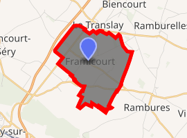
| |
 Framicourt  Framicourt | |
| Coordinates: 49°57′27″N 1°40′28″E | |
| Country | France |
| Region | Hauts-de-France |
| Department | Somme |
| Arrondissement | Amiens |
| Canton | Poix-de-Picardie |
| Intercommunality | CC Somme Sud-Ouest |
| Government | |
| • Mayor (2001–2008) | Alain Briet |
| Area 1 | 5.02 km2 (1.94 sq mi) |
| Population (2017-01-01)[1] | 176 |
| • Density | 35/km2 (91/sq mi) |
| Time zone | UTC+01:00 (CET) |
| • Summer (DST) | UTC+02:00 (CEST) |
| INSEE/Postal code | 80343 /80140 |
| Elevation | 119–166 m (390–545 ft) (avg. 130 m or 430 ft) |
| 1 French Land Register data, which excludes lakes, ponds, glaciers > 1 km2 (0.386 sq mi or 247 acres) and river estuaries. | |
Geography
Framicourt is situated on the D928 road, two miles from the Bresle River, the départemental border with Seine-Maritime and some 16 miles (26 km) southwest of Abbeville.
Population
| Year | 1962 | 1968 | 1975 | 1982 | 1990 | 1999 | 2006 |
|---|---|---|---|---|---|---|---|
| Population | 135 | 137 | 117 | 102 | 106 | 151 | 163 |
| From the year 1962 on: No double counting—residents of multiple communes (e.g. students and military personnel) are counted only once. | |||||||
gollark: It only runs reliably on stupid overpriced hardware.
gollark: A R C H L I N U X(is not what I run)
gollark: One day I'll probably just remove all the nonessential packages but Docker and actually have a sane setup. One day.
gollark: My server runs it.
gollark: https://www.alpinelinux.org/
See also
References
- "Populations légales 2017". INSEE. Retrieved 6 January 2020.
| Wikimedia Commons has media related to Framicourt. |
| Authority control |
|
|---|
This article is issued from Wikipedia. The text is licensed under Creative Commons - Attribution - Sharealike. Additional terms may apply for the media files.