Naours
Naours is a commune in the Somme department in Hauts-de-France in northern France.
Naours | |
|---|---|
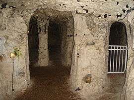 Chapel in the underground city of Naours | |
Location of Naours 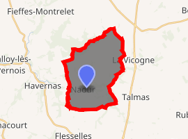
| |
 Naours  Naours | |
| Coordinates: 50°02′10″N 2°16′39″E | |
| Country | France |
| Region | Hauts-de-France |
| Department | Somme |
| Arrondissement | Amiens |
| Canton | Corbie |
| Intercommunality | CC Territoire Nord Picardie |
| Government | |
| • Mayor (2001–2008) | Geneviève Cazin |
| Area 1 | 16.55 km2 (6.39 sq mi) |
| Population (2017-01-01)[1] | 1,080 |
| • Density | 65/km2 (170/sq mi) |
| Time zone | UTC+01:00 (CET) |
| • Summer (DST) | UTC+02:00 (CEST) |
| INSEE/Postal code | 80584 /80260 |
| Elevation | 61–154 m (200–505 ft) (avg. 30 m or 98 ft) |
| 1 French Land Register data, which excludes lakes, ponds, glaciers > 1 km2 (0.386 sq mi or 247 acres) and river estuaries. | |
Geography
Naours is situated on the D117 and D60 crossroads, some 13 miles (21 km) north of Amiens.
Population
| 1962 | 1968 | 1975 | 1982 | 1990 | 1999 | 2006 |
|---|---|---|---|---|---|---|
| 636 | 683 | 721 | 962 | 1050 | 1124 | 1154 |
| Starting in 1962: Population without duplicates | ||||||
gollark: Huh. Wow.
gollark: Yes, indeed.
gollark: Ugh, BEE pyrobot.
gollark: How prescriptivist.
gollark: Oh. Oops. I clearly posted this before.
See also
References
- "Populations légales 2017". INSEE. Retrieved 6 January 2020.
External links
| Wikimedia Commons has media related to Naours. |
| Authority control |
|
|---|
This article is issued from Wikipedia. The text is licensed under Creative Commons - Attribution - Sharealike. Additional terms may apply for the media files.