Montigny-sur-l'Hallue
Montigny-sur-l'Hallue is a commune in the Somme department in Hauts-de-France in northern France.
Montigny-sur-l'Hallue | |
|---|---|
The church in Montigny-sur-l'Hallue | |
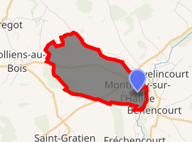
Location of Montigny-sur-l'Hallue 
| |
 Montigny-sur-l'Hallue  Montigny-sur-l'Hallue | |
| Coordinates: 49°58′50″N 2°26′37″E | |
| Country | France |
| Region | Hauts-de-France |
| Department | Somme |
| Arrondissement | Amiens |
| Canton | Corbie |
| Intercommunality | CC Territoire Nord Picardie |
| Government | |
| • Mayor (2001–2008) | Christian Hubau |
| Area 1 | 4.91 km2 (1.90 sq mi) |
| Population (2017-01-01)[1] | 205 |
| • Density | 42/km2 (110/sq mi) |
| Demonym(s) | Montignyens |
| Time zone | UTC+01:00 (CET) |
| • Summer (DST) | UTC+02:00 (CEST) |
| INSEE/Postal code | 80562 /80260 |
| Elevation | 43–116 m (141–381 ft) |
| 1 French Land Register data, which excludes lakes, ponds, glaciers > 1 km2 (0.386 sq mi or 247 acres) and river estuaries. | |
Geography
The commune is situated on the D78 road, some 13 miles (21 km) northeast of Amiens.
Population
| 1962 | 1968 | 1975 | 1982 | 1990 | 1999 | 2006 |
|---|---|---|---|---|---|---|
| 65 | 67 | 92 | 171 | 174 | 197 | 212 |
| Starting in 1962: Population without duplicates | ||||||
Personalities
- Albin de la Simone, singer and composer
gollark: Circumstantial evidence only.
gollark: Specifically, you apparently used Debian.
gollark: <@231856503756161025> I know what you did.
gollark: It was posted on esolangs. I posted it here because of the funny tagline.
gollark: https://media.discordapp.net/attachments/348702485994668033/832944565539045406/unknown.png
See also
References
- "Populations légales 2017". INSEE. Retrieved 6 January 2020.
| Wikimedia Commons has media related to Montigny-sur-l'Hallue. |
This article is issued from Wikipedia. The text is licensed under Creative Commons - Attribution - Sharealike. Additional terms may apply for the media files.