Greater Pittsburgh Region
The Greater Pittsburgh Region is a populous region in the United States which is named for its largest city and economic center, Pittsburgh, Pennsylvania. There are several official and unofficial boundary definitions which may be used to describe this region.[1] In the most restrictive definition, the region encompasses Pittsburgh's urban core county, Allegheny, and six nearby Pennsylvania counties.
Greater Pittsburgh | |
|---|---|
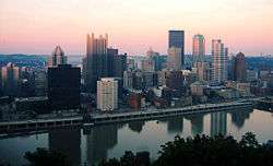 Downtown Pittsburgh | |
| Coordinates: 40°25′16″N 79°59′02″W | |
| Country | United States |
| State(s) | Pennsylvania West Virginia Ohio |
| Largest city | Pittsburgh |
| Population | |
| • Total | 2,333,367 |
| • Rank | 27th in the U.S. |
Garrett Nelson and Alasdair Rae's recent analysis of American commuter flows, "An Economic Geography of the United States: From Commutes to Megaregions", identified the Pittsburgh megaregion as a region encompassing the entirety or significant portions of 54 counties in Western Pennsylvania, Eastern Ohio, Northern West Virginia, and Western Maryland.[2] By this definition, the informal regional boundaries are similar to historical interpretations where the region is defined as the central portion of the Allegheny Plateau to the west and north of the Allegheny Front and south of Lake Erie and Pennsylvania's Northern Tier.[3] The hills and river valleys along the Upper Ohio River and its many eastern tributaries, including the Allegheny and Monongahela rivers have historically been the major centers of population of the region.[3]
Boundaries
| Historical population | |||
|---|---|---|---|
| Census | Pop. | %± | |
| 1850 | 138,290 | — | |
| 1860 | 178,831 | 29.3% | |
| 1870 | 262,204 | 46.6% | |
| 1880 | 355,869 | 35.7% | |
| 1890 | 664,778 | 86.8% | |
| 1900 | 1,083,846 | 63.0% | |
| 1910 | 1,471,800 | 35.8% | |
| 1920 | 1,759,989 | 19.6% | |
| 1930 | 2,023,269 | 15.0% | |
| 1940 | 2,062,556 | 1.9% | |
| 1950 | 2,213,236 | 7.3% | |
| 1960 | 2,768,938 | 25.1% | |
| 1970 | 2,759,443 | −0.3% | |
| 1980 | 2,648,991 | −4.0% | |
| 1990 | 2,468,289 | −6.8% | |
| 2000 | 2,431,087 | −1.5% | |
| 2010 | 2,356,285 | −3.1% | |
| Est. 2018 | 2,324,743 | [4] | −1.3% |
| U.S. Decennial Census[5] 1790–1960[6] 1900–1990[7] 1990–2000[8] | |||
As noted, there are no specific formal boundaries for the Greater Pittsburgh Region but the most liberal definition of the region's boundaries based on commuting patterns includes twenty-eight Pennsylvania counties (Allegheny, Armstrong, Beaver, Bedford, Blair, Butler, Cambria, Cameron, Centre, Clarion, Clearfield, Crawford, Elk, Erie, Fayette, Forest, Greene, Huntingdon, Indiana, Jefferson, Lawrence, Mercer, Mifflin, Somerset, Venango, Warren, Washington, and Westmoreland), nineteen West Virginia counties (Barbour, Brooke, Doddridge, Grant, Hancock, Harrison, Lewis, Marion, Marshall, Mineral, Monongalia, Ohio, Preston, Randolph, Taylor, Tucker, Tyler, Upshur, and Wetzel), five Ohio counties (Belmont, Columbiana, Harrison, Jefferson, and Monroe), and two Maryland counties (Allegany and Garrett).[2] The combined population of the megaregion was over 4.9 million in 2016.[9]
.svg.png)
There are also several formal definitions of Greater Pittsburgh which are often used in media mentions of the region. These include the Office of Management and Budget's Pittsburgh, PA Metropolitan Statistical Area (MSA) and Pittsburgh-New Castle-Weirton, PA-OH-WV Combined Statistical Area (CSA).[11] The Nielsen Corporation's Pittsburgh Designated Market Area (DMA) is another commonly used formal definition of the region.[12] There are nineteen counties included in at least one of these definitions and their combined population was over 2.9 million in 2016.[9]
| County | State | Formal Definition | Population
(2016)[9] | ||
|---|---|---|---|---|---|
| MSA | CSA | DMA | |||
| Allegheny | PA | Yes | Yes | Yes | 1,225,365 |
| Armstrong | PA | Yes | Yes | Yes | 66,486 |
| Beaver | PA | Yes | Yes | Yes | 167,429 |
| Brooke | WV | No | Yes | No | 22,977 |
| Butler | PA | Yes | Yes | Yes | 186,847 |
| Clarion | PA | No | No | Yes | 38,513 |
| Fayette | PA | Yes | Yes | Yes | 132,733 |
| Forest | PA | No | No | Yes | 7,321 |
| Garrett | MD | No | No | Yes | 29,425 |
| Greene | PA | No | No | Yes | 37,197 |
| Hancock | WV | No | Yes | No | 29,590 |
| Indiana | PA | No | Yes | Yes | 86,364 |
| Jefferson | OH | No | Yes | No | 66,704 |
| Lawrence | PA | No | Yes | Yes | 87,294 |
| Monongalia | WV | No | No | Yes | 104,622 |
| Preston | WV | No | No | Yes | 33,758 |
| Venango | PA | No | No | Yes | 52,582 |
| Washington | PA | Yes | Yes | Yes | 207,981 |
| Westmoreland | PA | Yes | Yes | Yes | 355,458 |
| Total Population | 2,938,646 | ||||
Many of the area's residents would probably dispute the inclusion of the State College, Johnstown, Altoona, Erie and West Virginia counties south of Morgantown in the Greater Pittsburgh Region. There is, nevertheless, a degree of interconnectedness between these areas and the formally designated Pittsburgh metropolitan area.
Culture
Greater Pittsburgh falls within the Northeast, Midwest and South regions of the United States as defined by the U.S. Census Bureau.[13] This has given the region a distinct regional culture which does not fit neatly into any of these larger regions. All counties do fall within the borders of Appalachia as defined by the Appalachian Regional Commission.[14] The City of Pittsburgh has been characterized as the "northern urban industrial anchor of Appalachia"[15]:which makes it an anomaly compared to much of Appalachia which has traditionally been characterized as southern, rural, and economically distressed.[15]
Joseph Scarpaci, professor emeritus of geography at Virginia Tech,[16] has described Pittsburgh as having "one foot in the East...and the other in the Midwest".[15] Barbara Johnstone, professor of rhetoric and linguistics at Carnegie Mellon University, ascribes this isolation and idiosyncratic cultural identity of the region to the difficulty of moving through the Allegheny Mountains and the Allegheny Plateau.
The Pittsburgh area was sort of isolated. It was very hard to get back and forth across the mountains. There's always been a sense that Pittsburgh was kind of a place unto itself—not really southern, not really Midwestern, not really part of Pennsylvania. People just didn't move very much.[17]
In his 2009 book, The Paris of Appalachia, Pittsburgh Post-Gazette writer Brian O'Neill meditates on this aspect of Pittsburgh's regional and cultural ambiguity. The title of the book is intentionally provocative:
"The Paris of Appalachia" some have called Pittsburgh derisively, because it's still the largest city along this gorgeous mountain chain that needs a better press agent. I've long felt we should embrace that title, though few are with me. Several tried to talk me out of slapping it on the cover, but were we called "The Paris of the Rockies," we wouldn't run from it. Sometimes we're so afraid of what others think, we're afraid to say who we are. This city is not Midwestern. It's not East Coast. It's just Pittsburgh, and there's no place like it. That's both its blessing and its curse.[18]
Arts
Visual Arts
Greater Pittsburgh is home to several museums, galleries, and organizations which promote appreciation for the visual arts. The largest art museum in the region is the Carnegie Museum of Art, founded in 1895 by industrialist Andrew Carnegie and located in Pittsburgh's Oakland neighborhood. It is renowned for its collections of 19th and 20th century decorative art, Japanese prints, and old master prints.[19] Contemporary art museums include the Mattress Factory and the Andy Warhol Museum, both located on Pittsburgh's North Side.[20][21]
Other regional visual arts museums include:[22][23]
- Frick Art and Historical Center (Point Breeze, Pittsburgh)
- Contemporary Craft (Strip District, Pittsburgh)
- ToonSeum (Downtown, Pittsburgh)
- Westmoreland Museum of American Art (Greensburg)
- Southern Alleghenies Museum of Art (Multiple locations - Loretto, Ligonier Valley, Johnstown, and Altoona)[24]
- The Maridon Museum (Butler)
- University Museum at Indiana University of Pennsylvania (Indiana)
- Hoyt Institute of Fine Arts (New Castle)
- Venango Museum of Art, Science, and Industry (Oil City)
- Palmer Museum of Art (University Park)
- Erie Art Museum (Erie)
- Juniata College Museum of Art (Huntingdon)
- Art Museum of West Virginia University (Morgantown)
Sports and recreation
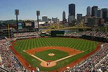
The Pittsburgh area served as a launchpad for the professionalization of both American football and ice hockey in the 1890s and 1900s. The first professional player (William Heffelfinger) played for a Pittsburgh football team in 1892, which was followed by the first open professional (John Brallier), the first all-professional team (the Latrobe Athletic Association), and a participant in the first all-professional league (the Pittsburgh Stars of the first National Football League). In the case of ice hockey, the Western Pennsylvania Hockey League was the first hockey league to pay its players in 1901, eventually merging into the first fully pro league, the International Professional Hockey League, in 1904. Professional hockey in Pennsylvania predated the professionalization of the game in Canada (where it eventually came to dominate in the early 20th century) by four years.
Today, the region is home to three major league franchises in baseball, football, and hockey; several minor league teams in soccer, baseball, and hockey; and three major NCAA universities.
Golf
Golf in the metro area boasts such courses as Oakmont Country Club, which has hosted the U.S. Open a record eight times, and Foxburg Country Club the oldest continuous club in the U.S. Such tournaments as the 84 Lumber Classic, Pittsburgh Senior Open and the current Mylan Classic call the region home. Area courses have also hosted multiple PGA Championships, LPGA Championships, U.S. Women's Opens and Ryder Cup matches.
Annual sports events
Annual sporting events include the Head of the Ohio crew race, Three Rivers Regatta, Pittsburgh Vintage Grand Prix, and the Pittsburgh Marathon.
The regions rivers have hosted the Bassmaster Classic and Forrest Wood Cup and the city has enjoyed having one of only two teams to host the Major League Baseball All Star Game a record eight times. The area has also hosted the NHL All Star Game, NHL Winter Classic, Senior Olympics, NHL Entry Draft, AHL All Star Game, NCAA Tournament and has been selected as the site of the 2012 Frozen Four.
Winter in the region sees sport continue at such rinks at PPG Place and North Park as well as area ski resorts like Boyce Park, Seven Springs Mountain Resort, Hidden Valley, Laurel Mountain and Wisp.
Economy
Historically, Pittsburgh has been grouped in the "rust belt";[25] however, reflective of the rebound of the region within the last generation, the metro area has come to be associated with the newly rebranded "Great Lakes Basin" gaining representation in the Great Lakes Metro Chamber Coalition,[26] while the "America 2050" organization claims that Pittsburgh is one of the "principal cities" of the Great Lakes Megalopolis[27] despite the fact that the city is about 120 miles (190 km) from Lake Erie.
Pittsburgh's association with the Great Lakes region is due in part to its economic, demographic and commuter connections to Great Lakes cities like Cleveland, Erie, Toledo and even Detroit. Christopher Briem, an economist at the University of Pittsburgh's University Center for Social and Urban Research, has noted that southwestern Pennsylvania is "far more interconnected" with northeastern Ohio than it is with the eastern half of Pennsylvania, and that the industries of Pittsburgh are primarily linked to Ohioan cities such as Youngstown, Akron, and Cleveland, not to Pennsylvanian cities such as Allentown, Scranton, or Philadelphia.[28] He notes that, conversely, the population centers of northeastern Ohio are primarily connected with Pittsburgh and only secondarily connected to the state capital of Columbus. Briem argues that "In so many ways the state boundaries we think of as important are no more than lines on a map."[28] In recognizing their economic interdependence, Briem has popularized the term "Cleveburgh" to refer collectively to the cities of Cleveland and Pittsburgh, along with the smaller towns dotting the corridor of I-76 between the cities.[28][29][30][31][32] Robert Lang and Arthur Nelson of the Metropolitan Institute at Virginia Tech also identify the region between Cleveland and Pittsburgh as being an interconnected "megapolitan area" and refer to it as the "Steel Corridor".[33]
The scope of Pittsburgh's metropolitan influence on the surrounding area is of more than just academic interest. For example, the organization "Power of 32" focuses on addressing the issues of the 32-county metropolitan area roughly centered on Pittsburgh—a region which includes portions of Pennsylvania, Ohio, West Virginia, and Maryland. Despite being divided into four states and three Census Bureau—defined regions, this area functions as an interdependent economic region.[34] Power of 32 asserts that "[t]he 32-county region has common challenges and opportunities in the global economy, but is larger than the scope of any one single political entity, authority, or organization",[35] and that "[t]he only thing we find at artificial boundaries are problems, not solutions."[36] Power of 32 is supported in its efforts by "30 to 40 other foundations"[34] and funded by several Pittsburgh-area endowments including the Richard King Mellon Foundation and The Heinz Endowments.[34]
Education
_seen_from_the_Cathedral_of_Learning_May_14%2C_2010.jpg)
The largest school district in the area is the Pittsburgh Public Schools, with the school districts of Allegheny County also boasting large student bodies. Many private schools also serve the core county of Allegheny. More public districts are found throughout Beaver, Westmoreland, and Washington counties, as well as private schools in each county.
Several area colleges and universities serve the region. The region's suburbs also host several colleges and universities such as: Clarion University of Pennsylvania, LaRoche College, Slippery Rock University, Westminster College and Grove City College north of the city, Robert Morris University and Geneva College west of the city, Washington & Jefferson College, California University of Pennsylvania and Waynesburg University to the south, and Seton Hill University, Saint Vincent College and Indiana University of Pennsylvania to the east.
Transportation
Airports
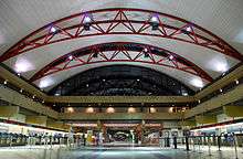
Pittsburgh International Airport (IATA: PIT) is located 17 miles (27 km) to the west of downtown Pittsburgh in Findlay.[37] The smaller but less crowded Arnold Palmer Regional Airport (IATA: LBE) to the east of downtown in Latrobe provide commercial service to the metro area.
Pittsburgh International was the fortress hub of US Airways from 1952 to 2005 with over 500 daily departures to more than 110 destinations in 2000. By 2007, fewer than 70 departures to 21 destinations remained.[38] In 2007, US Airways did select the airport for its new $25 million, 27,000 sq ft (2,500 m2), 600-employees-strong Global Flight Operations Center. Since being de-hubbed the airport has seen expanded service from JetBlue, Southwest Airlines and Delta Air Lines' direct trans-Atlantic service to Paris.
Arnold Palmer Regional Airport offers commercial service via Spirit Airlines to the Carolinas, Florida and Texas. Palmer has had commercially scheduled air service since the 1980s.
Allegheny County Airport (IATA: AGC) in suburban West Mifflin, Pennsylvania, is the area's largest general aviation airport. The historic landmark, art deco terminal was the main passenger airport for the area until 1952. Allegheny opened in 1931 as the nation's third-largest and first with "hard surface" runways.
Smaller suburban airports serve as private plane and corporate jet bases include:
- North Metro:
- Butler County Airport
- Zelienople Municipal Airport
- Rock Airport
- New Castle Municipal Airport
- Lakehill Airport
- South Metro:
- East Metro:
- Pittsburgh-Monroeville Airport
- Greensburg Jeannette Regional Airport
- Indiana County-Jimmy Stewart Airport
- Arnold Palmer Regional Airport
- West Metro:
- Beaver County Airport
- Eddie Dew Memorial Airpark (Ohio)
- Jefferson County Airpark (Ohio)
- Herron Airport (West Virginia)
- Wheeling Airport (West Virginia)
Interstates
The Pittsburgh area is served by four main-line Interstates including the Pennsylvania Turnpike (which is co-signed with I-76 and in the extreme eastern part of the region also co-signed with I-70):


It's also served by several Interstate spur routes:


Other expressways


- Fort Duquesne Boulevard serving as a downtown expressway between I-279 and I-579.
Port
The Port of Pittsburgh ranks as the 21st-largest port in the United States with almost 34 million short tons of river cargo for 2011, the port ranked 9th-largest in the U.S. when measured in domestic trade.[39]
Mass transit
The Port Authority of Allegheny County (PAT) is the largest mass transit service in the metro area and includes a 26-mile subway/light rail system, all serving the central core. This system is complemented by BTA and Town & Country to north destinations, BCTA and NTC to northwest destinations, WCTA and IndiGo to eastern destinations, WCT, MMVTA and FACT serving southern destinations. The University of Pittsburgh Transportation System also provides services in the eastern core of the metropolitan area while Mountain Line Transit serves the city, western suburbs and an express route south to Morgantown, West Virginia.
A metro map of all fixed route transit routes for Pennsylvania counties can be found here.[40]
Rail
Amtrak serves the region with stops at Penn Station in Downtown Pittsburgh, Connellsville to the southeast and both Greensburg and Latrobe to the east.
Freight rail is a major industry for the area with the Pittsburgh Line and the Conway Yard among other infrastructure serving the region.
Interstate bus
Both the Greyhound Lines and Megabus serve the area.
See also
| Wikimedia Commons has media related to Pittsburgh metropolitan area. |
- Western Pennsylvania
- Northwest Pennsylvania
- Pittsburgh Media Market
- Pennsylvania census statistical areas
- List of Pennsylvania metropolitan areas
References
- "FAQ - Pittsburgh Today". Pittsburgh Today. Retrieved 2018-03-01.
- Nelson, Garrett Dash; Rae, Alasdair (2016-11-30). "An Economic Geography of the United States: From Commutes to Megaregions". PLOS ONE. 11 (11): e0166083. doi:10.1371/journal.pone.0166083. ISSN 1932-6203. PMC 5130203. PMID 27902707.
- Buck, Solon (1967). "The Planting of civilization in western Pennsylvania | Digital Pitt". digital.library.pitt.edu. pp. 3–4. Retrieved 2018-03-02.
- "Population and Housing Unit Estimates". Retrieved May 10, 2019.
- "U.S. Decennial Census". United States Census Bureau. Retrieved May 18, 2014.
- "Historical Census Browser". University of Virginia Library. Retrieved May 18, 2014.
- "Population of Counties by Decennial Census: 1900 to 1990". United States Census Bureau. Retrieved May 18, 2014.
- "Census 2000 PHC-T-4. Ranking Tables for Counties: 1990 and 2000" (PDF). United States Census Bureau. Retrieved May 18, 2014.
- Bureau, US Census. "County Population Totals and Components of Change: 2010-2016". www.census.gov. Archived from the original on 2017-09-15. Retrieved 2018-03-04.
- Alasdair, Rae; G.D., Nelson, Garrett (2017-01-31). "United States Commutes and Megaregions data for GIS". figshare. doi:10.15131/shef.data.4110156.v5.
- Donovan, Shaun (2015-07-15). "OMB BULLETIN NO. 15-01: Revised Delineations of Metropolitan Statistical Areas, Micropolitan Statistical Areas, and Combined Statistical Areas, and Guidance on Uses of the Delineations of These Areas" (PDF). Obama White House Archives. Retrieved March 1, 2018.
- "NIELSEN DMA—DESIGNATED MARKET AREA REGIONS 2015–2016" (PDF). Video Advertising Bureau (VBA). Retrieved 2018-03-01.
- "Census Regions and Divisions of the United States" (PDF). U.S. Census Bureau. Retrieved 2018-03-06.
- "Counties in Appalachia - Appalachian Regional Commission". www.arc.gov. Retrieved 2018-03-07.
- Scarpaci, Joseph L.; Patrick, Kevin Joseph (June 28, 2006). Pittsburgh and the Appalachians: cultural and natural resources in a postindustrial age. University of Pittsburgh Pre. ISBN 978-0-8229-4282-5. Retrieved February 3, 2011.
- "Joseph L. Scarpaci". Virginia Tech, Department of Geography. Retrieved 2018-03-06.
- Malady, Matthew J.X. "Where Yinz At: Why Pennsylvania is the most linguistically rich state in the country". Slate. Retrieved 1 May 2014.
- O'Neill, Brian (2009). The Paris of Appalachia: Pittsburgh in the Twenty-first Century. Carnegie Mellon University Press. ISBN 978-0-88748-509-1.
- "Carnegie Museum of Art". Pittsburgh Art Places. Retrieved 2018-03-07.
- "History | Mattress Factory". www.mattress.org. Retrieved 2018-03-07.
- "Museum - The Andy Warhol Museum". The Andy Warhol Museum. Retrieved 2018-03-07.
- "Pittsburgh Art Places". www.pittsburghartplaces.org. Retrieved 2018-03-07.
- "Home - PA Federation of Museums and Historical Places". PA Federation of Museums and Historical Places. Retrieved 2018-03-07.
- "Southern Alleghenies Museum of Art | Welcome!". www.sama-art.org. Retrieved 2018-03-07.
- Mostrous, Alexi (September 24, 2009). "Pittsburgh, Site of G-20 Summit, Is Shaking Off Its Smoky Image". The Washington Post. Retrieved February 9, 2011.
- "Who we are". Great Lakes Metro Chambers Coalition. Retrieved February 9, 2011.
- "Great Lakes – America 2050". America 2050. Retrieved February 9, 2011.
- Briem, Christopher (January 2, 2011). "Welcome to Cleveburgh! Pittsburghers need to rethink their place in the world". Pittsburgh Post-Gazette. Retrieved January 24, 2011.
- Briem, Christopher (January 2, 2011). "A Turnpike Runs Through It". Null Space. Retrieved February 1, 2011.
- Briem, Christopher (January 22, 2011). "Residents of Cleveland and Pittsburgh need to rethink their place in the world". The Plain Dealer. Retrieved February 1, 2011.
- Roman, Joe; Dennis Yablonsky (January 23, 2011). "Tech Belt Initiative helps area compete in global markets:". The Plain Dealer. Retrieved October 17, 2011.
- "Cleveburgh". Crain's Cleveland Business. April 23, 2007. Retrieved October 17, 2011.
- Lang, Robert E.; Arthur C. Nelson (January 2007). "The Rise of the Megapolitans" (PDF). Planning: 7–12.
- Carlisle, Anthony Todd (January 20, 2011). "A newsmaker you should know: He's expanding power of community". Pittsburgh Post-Gazette. Retrieved January 24, 2011.
- "About P32". Power of 32. Archived from the original on 2010-07-22. Retrieved January 24, 2011.
- "Get Informed". Power of 32. Archived from the original on 2010-07-27. Retrieved January 31, 2011.
- Pittsburgh Pennsylvania Convention and Visitors Bureau. visitpittsburgh.com
- David Grossman, "Dismantling Pittsburgh: Death of an airline hub," USA Today October 15, 2007
- http://aapa.files.cms-plus.com/PDFs/2011%20U%20S%20%20PORT%20RANKINGS%20BY%20CARGO%20TONNAGE.pdf
- http://www.spcregion.org/pdf/servicearea10.pdf
| Government |  | |
|---|---|---|
| Economy | ||
| Other topics | ||
| ||
.svg.png)
.svg.png)
Great Lakes megaregion as defined by RPA | ||
|---|---|---|
Note: A few Great Lakes regions cities in Canada are left out. Metropolitan areas have +150,000 according to source at the time estimated. | ||
| Great Lakes region cities | 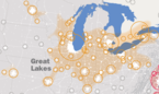 | |
| Surrounding cities |
| |
| Cities of states south of region | ||
| Other metro-regions | ||