Grand Rapids metropolitan area
The Grand Rapids metropolitan area is a triangular shaped Metro Triplex, in West Michigan, which fans out westward from the primary hub city of Grand Rapids, Michigan to the other two metro hubs of Muskegon and Holland. The metropolitan area has an estimated population of 1,059,113 as of 2017.[2] The region, noted in particular for its western edge abutting the Lake Michigan shoreline and its beaches, is a popular tourist and vacation destination during the summer. Noted popular metro area beach towns include Grand Haven, Holland, Muskegon, and Saugatuck.
Grand Rapids metropolitan area Grand Rapids–Kentwood MSA Grand Rapids–Kentwood–Muskegon CSA | |
|---|---|
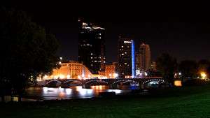 Grand Rapids Riverfront | |
| Coordinates: 42.9703°N 85.6691°W | |
| Country | |
| State | |
| Largest city | Grand Rapids |
| Counties | |
| Area | |
| • Total | 6,801 sq mi (17,610 km2) |
| • Land | 2,669.5 sq mi (6,914 km2) |
| • Water | 1,131.5 sq mi (2,931 km2) |
| Population (2017 est.) | |
| • Metro density | 396.7/sq mi (153.2/km2) |
| • MSA | 1,059,113 |
| • CSA | 1,456,935 |
| Time zone | UTC-5 (EST) |
| • Summer (DST) | UTC-4 (EDT) |
The metropolitan area is home to many attractions. Frederik Meijer Gardens & Sculpture Park is located in the outskirts of Grand Rapids. Michigan's Adventure theme park is just north of Muskegon, and the Grand Rapids Art Museum and the DeVos Place Convention Center are both in downtown Grand Rapids. The Grand River flows through the metropolitan area and is noted for its fishing, kayaking, and canoeing.
Definitions
The Grand Rapids-Kentwood Metropolitan Statistical Area, as defined by the United States Census Bureau, is an area consisting of four counties in western Michigan, anchored by the cities of Grand Rapids and Wyoming. The MSA has a population of 988,938 at the 2010 census. It comprises four counties which include the central county of Kent, and the outlying counties of Ionia, Montcalm, and Ottawa.[3]
The Grand Rapids – Kentwood – Muskegon Combined Statistical Area is the 2nd largest CSA in the U.S. state of Michigan (behind Metro Detroit). The CSA had a population of 1,320,064 at the 2010 census. The primary cultural and financial centers of the region are Grand Rapids, Muskegon and Holland. It includes the four counties in the Grand Rapids-Kentwood MSA plus one metropolitan area, adding the Muskegon, MI MSA of Muskegon County, and two micropolitan areas of Holland of Allegan County, and Big Rapids of Mecosta County for a total of seven counties.
The Grand Rapids metropolitan area is part of the Great Lakes Megalopolis containing an estimated 54 million people.
Communities

Places with more than 50,000 inhabitants
- Grand Rapids (Principal city of MSA and CSA)
- Wyoming (Principal city of MSA)
- Kentwood
Places with 20,000 to 50,000 inhabitants
- Allendale Charter Township
- Byron Township
- Gaines Charter Township
- Georgetown Charter Township
- Holland (Principal city of CSA)
- Holland Charter Township
- Muskegon (Principal city of CSA)
- Norton Shores
- Plainfield Charter Township
- Walker
Places with 10,000 to 20,000 inhabitants
- Ada Township
- Allendale (CDP)
- Alpine Township
- Caledonia Township
- Cannon Township
- Cascade Charter Township
- Comstock Park (CDP)
- Cutlerville (CDP)
- East Grand Rapids
- Forest Hills (CDP)
- Fruitport Charter Township
- Grand Haven
- Grand Haven Charter Township
- Grand Rapids Charter Township
- Grandville
- Ionia
- Jenison (CDP)
- Muskegon Charter Township
- Muskegon Heights
- Park Township
- Northview (CDP)
- Spring Lake Township
Places with 5,000 to 10,000 inhabitants
Places with 2,500 to 5,000 inhabitants
Places with fewer than 2,500 inhabitants
Unincorporated places
|
|
Demographics
| Historical population | |||
|---|---|---|---|
| Census | Pop. | %± | |
| 1900 | 236,464 | — | |
| 1910 | 270,065 | 14.2% | |
| 1920 | 294,229 | 8.9% | |
| 1930 | 357,933 | 21.7% | |
| 1940 | 370,289 | 3.5% | |
| 1950 | 431,214 | 16.5% | |
| 1960 | 540,833 | 25.4% | |
| 1970 | 624,733 | 15.5% | |
| 1980 | 701,050 | 12.2% | |
| 1990 | 798,482 | 13.9% | |
| 2000 | 935,393 | 17.1% | |
| 2010 | 993,670 | 6.2% | |
| Est. 2019 | 1,077,370 | 8.4% | |
| U.S. Decennial Census[4] | |||
2010 Census
As of the census of 2010, there were 774,160 people, 290,340 households, and 197,867 families residing within the MSA. The racial makeup of the MSA was 83.1% White, 8.1% African American, 0.5% Native American, 1.9% Asian, 0.03% Pacific Islander, 3.8% from other races, and 2.7% from two or more races. Hispanic or Latino of any race were 8.4% of the population.
2000 Census
As of the census[5] of 2000, there were 740,482 people, 272,130 households, and 188,192 families residing within the MSA. The racial makeup of the MSA was 85.71% White, 7.40% African American, 0.53% Native American, 1.51% Asian, 0.05% Pacific Islander, 2.82% from other races, and 1.99% from two or more races. Hispanic or Latino of any race were 6.02% of the population.
The median income for a household in the MSA was $43,251, and the median income for a family was $49,715. Males had a median income of $37,853 versus $25,483 for females. The per capita income for the MSA was $19,173.
Education
- Aquinas College
- Calvin College
- Cornerstone University
- Davenport University
- Grace Bible College
- Grand Rapids Community College
- Grand Valley State University
- Hope College
- Kuyper College
- Kendall College of Art and Design
- Muskegon Community College
- Thomas M. Cooley Law School
- Western Theological Seminary
The area also has campuses for Baker College, Ferris State University, Davenport University, Western Michigan University, and University of Phoenix, and the Michigan State University College of Human Medicine.
Economy
Companies in the Grand Rapids metropolitan area
- Alticor (formerly Amway), Ada
- American Seating, Grand Rapids
- Baker Books, Grand Rapids
- Bissell, Grand Rapids
- Eerdmans, Grand Rapids
- Family Christian Stores, Grand Rapids
- Farmers Insurance Group, Grand Rapids
- GE Aviation, Cascade
- Gentex, Zeeland
- Gerber Products Company, Fremont
- Goodrich Quality Theaters, Grand Rapids
- Gordon Food Service, Wyoming
- Haworth, Holland
- Herman Miller, Zeeland
- Howard Miller, Zeeland
- Loeks Theatres, Wyoming
- Meijer, Walker
- Mercantile Bank of Michigan, Grand Rapids
- Old Orchard Brands, Sparta
- Perrigo, Allegan
- Plascore Incorporated, Zeeland
- SpartanNash, Byron Township
- Steelcase, Grand Rapids
- Sun Chemical, Muskegon
- Universal Forest Products, Grand Rapids
- Wolverine World Wide, Rockford
- X-Rite, Kentwood
- Zondervan Publishing, Cascade
Culture and tourism
- Centerpointe Mall
- The Lakes Mall
- Rivertown Crossings Mall
- Tanger Outlet Mall
- Woodland Mall
See also
- Michigan census statistical areas
References
- "National Core Based Statistical Areas Gazetteer File". U.S. Census Bureau. United States Census Bureau. Retrieved 3 January 2018.
- "Annual Estimates of the Resident Population: April 1, 2010 to July 1, 2016 - United States -- Metropolitan and Micropolitan Statistical Area; and for Puerto Rico". American FactFinder. United States Census Bureau. Retrieved 3 January 2018.
- Mulvaney, Mick. "OMB BULLETIN NO. 18-04" (PDF). Whitehouse.gov. Office of Management & Budget. Retrieved 19 August 2019.
- "U.S. Decennial Census". United State Census Bureau. Archived from the original on May 12, 2015. Retrieved April 12, 2020.
- "U.S. Census website". United States Census Bureau. Retrieved 2008-01-31.
Great Lakes megaregion as defined by RPA | ||
|---|---|---|
Note: A few Great Lakes regions cities in Canada are left out. Metropolitan areas have +150,000 according to source at the time estimated. | ||
| Great Lakes region cities | 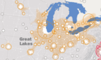 | |
| Surrounding cities |
| |
| Cities of states south of region | ||
| Other metro-regions | ||
| Authority control |
|
|---|