Madison, Wisconsin, metropolitan statistical area
The Madison, WI Metropolitan Statistical Area (MSA), as defined by the United States Office of Management and Budget, is an area consisting of Columbia, Dane, Green, and Iowa counties[1] in Wisconsin, anchored by the city of Madison. As of the 2010 census, the MSA had a population of 605,435. The latest Census estimate as of July 1, 2017 puts the population at 654,230. The Madison–Janesville–Beloit Combined Statistical Area (CSA) consists of the four counties in the Madison MSA as well as Rock and Sauk counties, and had a population estimate of 880,520.
Definitions
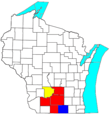
The Madison–Janesville–Beloit Combined Statistical Area (CSA) is made up of six counties.[1] The statistical area includes two metropolitan areas and one micropolitan area. As of 2016, the CSA had a population of 874,498.[2] .
- Metropolitan Statistical Areas (MSAs)
- Madison (Columbia, Dane, Green, and Iowa counties)
- Janesville–Beloit (Rock County)
- Micropolitan Statistical Areas (μSAs)
- Baraboo (Sauk County)
| Historical population | |||
|---|---|---|---|
| Census | Pop. | %± | |
| 1840 | 7,028 | — | |
| 1850 | 69,416 | 887.7% | |
| 1860 | 162,791 | 134.5% | |
| 1870 | 192,943 | 18.5% | |
| 1880 | 194,207 | 0.7% | |
| 1890 | 206,572 | 6.4% | |
| 1900 | 230,598 | 11.6% | |
| 1910 | 241,109 | 4.6% | |
| 1920 | 261,670 | 8.5% | |
| 1930 | 291,385 | 11.4% | |
| 1940 | 320,791 | 10.1% | |
| 1950 | 378,060 | 17.9% | |
| 1960 | 454,377 | 20.2% | |
| 1970 | 547,469 | 20.5% | |
| 1980 | 599,470 | 9.5% | |
| 1990 | 649,147 | 8.3% | |
| 2000 | 742,953 | 14.5% | |
| 2010 | 827,742 | 11.4% | |
| Est. 2019 | 892,661 | [3] | 7.8% |
| U.S. Decennial Census[4] 1790–1960[5] 1900–1990[6] 1990–2000[7] 2010–2014[8] | |||
The CSA totals are the totals of all the counties listed above, regardless of whether they were included in the Combined Statistical Area at the time.
Communities
Cities with more than 10,000 inhabitants
Cities with less than 10,000 inhabitants
Villages with less than 10,000 inhabitants
- Albany
- Arena
- Arlington
- Avoca
- Barneveld
- Belleville
- Black Earth
- Blanchardville (partial)
- Blue Mounds
- Brooklyn
- Browntown
- Cambria
- Cambridge (partial)
- Cazenovia (partial)
- Clinton
- Cobb
- Cottage Grove
- Cross Plains
- Dane
- Deerfield
- DeForest
- Doylestown
- Fall River
- Footville
- Friesland
- Highland
- Hollandale
- Ironton
- La Valle
- Lake Delton
- Lime Ridge
- Livingston (partial)
- Loganville
- Maple Bluff
- Marshall
- Mazomanie
- Merrimac
- McFarland
- Monticello
- Montfort (partial)
- Mount Horeb
- New Glarus
- North Freedom
- Orfordville
- Pardeeville
- Plain
- Poynette
- Prairie du Sac
- Randolph (partial)
- Rewey
- Ridgeway
- Rio
- Rock Springs
- Rockdale
- Sauk City
- Shorewood Hills
- Spring Green
- West Baraboo
- Wyocena
Census-designated places
- Bluffview
- Hanover
- Juda
- Lake Wisconsin
- Windsor
Towns
Columbia County
Dane County
- Albion
- Berry
- Black Earth
- Blooming Grove
- Blue Mounds
- Bristol
- Burke
- Christiana
- Cottage Grove
- Cross Plains
- Dane
- Deerfield,
- Dunkirk
- Dunn
- Madison
- Mazomanie
- Medina
- Middleton
- Montrose
- Oregon
- Perry
- Pleasant Springs
- Primrose
- Roxbury
- Rutland
- Springdale
- Springfield
- Sun Prairie
- Vermont
- Verona
- Vienna
- Westport
- Windsor
- York
Green County
Iowa County
Rock County
Demographics
As of the census[9] of 2000, there were 501,774 people, 202,687 households, and 121,171 families residing within the MSA. The racial makeup of the MSA was 90.26% White, 3.50% African American, 0.32% Native American, 2.99% Asian, 0.03% Pacific Islander, 1.27% from other races, and 1.63% from two or more races. Hispanic or Latino of any race were 3.05% of the population.
The median income for a household in the MSA was $45,602, and the median income for a family was $55,159. Males had a median income of $35,250 versus $26,322 for females. The per capita income for the MSA was $21,832.
See also
- Wisconsin census statistical areas
References
- "OMB Bulletin No. 13-01: Revised Delineations of Metropolitan Statistical Areas, Micropolitan Statistical Areas, and Combined Statistical Areas, and Guidance on Uses of the Delineations of These Areas" (PDF). United States Office of Management and Budget. February 28, 2013. Archived from the original (PDF) on March 19, 2013. Retrieved May 22, 2015.
- United States Census Bureau. Annual Estimates of the Resident Population: April 1, 2010 to July 1, 2016 - United States -- Combined Statistical Area; and for Puerto Rico: 2016 Population Estimates.
- "County Totals Dataset: Population, Population Change and Estimated Components of Population Change: April 1, 2010 to July 1, 2019". Retrieved January 7, 2019.
- "U.S. Decennial Census". United States Census Bureau. Retrieved August 9, 2015.
- "Historical Census Browser". University of Virginia Library. Retrieved August 9, 2015.
- Forstall, Richard L., ed. (March 27, 1995). "Population of Counties by Decennial Census: 1900 to 1990". United States Census Bureau. Retrieved August 9, 2015.
- "Census 2000 PHC-T-4. Ranking Tables for Counties: 1990 and 2000" (PDF). United States Census Bureau. April 2, 2001. Retrieved August 9, 2015.
- "State & County QuickFacts". United States Census Bureau. Archived from the original on July 17, 2011. Retrieved January 23, 2014.
- "U.S. Census website". United States Census Bureau. Retrieved 2008-01-31.
External links
| Surrounding communities |
|  | ||||
|---|---|---|---|---|---|---|
| Counties | ||||||
| Geographic Regions | ||||||

Great Lakes megaregion as defined by RPA | ||
|---|---|---|
Note: A few Great Lakes regions cities in Canada are left out. Metropolitan areas have +150,000 according to source at the time estimated. | ||
| Great Lakes region cities |  | |
| Surrounding cities |
| |
| Cities of states south of region | ||
| Other metro-regions | ||