Anne Arundel County, Maryland
Anne Arundel County (![]()
Anne Arundel County | |
|---|---|
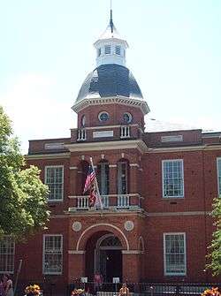 The Anne Arundel County Courthouse facing Church Circle in Annapolis | |
 Flag  Seal | |
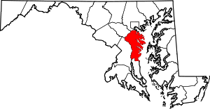 Location within the U.S. state of Maryland | |
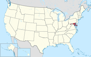 Maryland's location within the U.S. | |
| Coordinates: 39°00′N 76°36′W | |
| Country | |
| State | |
| Founded | April 9, 1650 |
| Named for | Anne Arundell |
| Seat | Annapolis |
| Largest community | Glen Burnie |
| Government | |
| • County Executive | Steuart Pittman |
| Area | |
| • Total | 588 sq mi (1,520 km2) |
| • Land | 415 sq mi (1,070 km2) |
| • Water | 173 sq mi (450 km2) 29%% |
| Population (2010) | |
| • Total | 537,656 |
| • Estimate (2019) | 579,234 |
| • Density | 910/sq mi (350/km2) |
| Time zone | UTC−5 (Eastern) |
| • Summer (DST) | UTC−4 (EDT) |
| Congressional districts | 2nd, 3rd, 4th, 5th |
| Website | www |
Anne Arundel County is included in the Baltimore–Columbia–Towson metropolitan statistical area, which is also included in the Washington–Baltimore–Arlington combined statistical area.
History
The County was named for Lady Anne Arundell, (1615/1616–1649), the daughter of Thomas Arundell, 1st Baron Arundell of Wardour, members of the ancient family of Arundells in Cornwall, England. She married Cecilius Calvert, second Lord Baltimore, (1605–1675), and the first Lord Proprietor of the colony, Province of Maryland, in an arranged marriage contract in 1627 or 1628.
Anne Arundel County (modern spelling adds an 'e' to her first name of "Ann" and removes the second 'L' from the family name of "Arundell" – but the old traditional spelling of her name is still used in the title of the local historical society, the Ann Arundell County Historical Society) was originally part of St. Mary's County, the province's first erected county in the southern portion of the Province of Maryland which had first been settled by the arriving settlers in 1634. In 1650, the year after Lady Ann Arundell's death, the County separated from St. Mary's and "erected" into its own jurisdiction and became the 3rd of the 23 Maryland counties. It was composed of the hundreds of Town Neck, Middle Neck, Broad Neck, South River, West River and Herring Creek.[4] Between 1654 and 1658, the County was known as "Providence" by many of its early settlers.
On March 25, 1655, during the English Civil War, (1642-1651), in Europe, the Battle of the Severn, the first naval colonial battle ever fought in America, was fought in Anne Arundel County on the Severn River between Puritan forces supporting the Commonwealth of England and forces loyal to the Lord Proprietor, Cecilius Calvert. The Commonwealth forces under William Fuller were victorious.
In 1692, the Church of England, also known as the Anglican Church, became the established church of the Province of Maryland through an Act of the General Assembly. Ten counties had been established in the colony, and those counties were divided into 30 parishes, with vestrymen appointed within each. Ann Arrundell County was divided into four parishes: Herring Creek, South River, Middle Neck and Broad Neck.[5]
Between 1694 and 1695, the provincial capital of Maryland was moved from St. Mary's City along the northern shore of the Potomac River across from the southern colonial border with the Province of Virginia in St. Mary's County farther north along the western shore of the Chesapeake Bay, midway in the colony to Annapolis in Anne Arundel County. Prior to the move, Annapolis was known as "Providence".[6]
During the American Revolutionary War, citizens of Anne Arundel County supported the Continental Army by providing troops for three regiments. The 3rd Maryland Regiment, the 4th Maryland Regiment, and the 6th Maryland Regiment were recruited in the county.
During the War of 1812, the one of the original six heavy frigates of the recently reestablished United States Navy, "U.S.S. Constitution" sailed from Annapolis prior to its victorious engagement with the "H.M.S. Guerriere" of the British Royal Navy.
On May 22, 1830, the inaugural horse-drawn train of the Baltimore and Ohio Railroad travelled the 13 miles (21 km) of the newly completed track from Mount Clare Station in southwestern Baltimore City to Ellicott Mills, (now Ellicott City), then in the Western or Howard District (now Howard County) of Anne Arundel County. This was the first regular railroad passenger service in the United States.[7] In 1831, land west of the railroad was considered the Howard District of Anne Arundel County. In 1851, The Howard District was broken off to form Howard County, now the 21st county in Maryland (of 23).[8]
The County has a number of properties on the National Register of Historic Places.[9]
Geography
According to the U.S. Census Bureau, the county has a total area of 588 square miles (1,520 km2), of which 415 square miles (1,070 km2) is land and 173 square miles (450 km2) (29%) is water.[10] Anne Arundel County is located to the south of the city of Baltimore.[11]
Most of the county's borders are defined by water. To the east lies the western shore of the Chesapeake Bay, and numerous tidal tributaries of the Bay indent the shoreline, the various rivers, creeks, streams, inlets forming prominent peninsulas, also known as "necks" (as further south in Virginia). The largest of these tributaries include (from north to south), the Magothy River, Severn River, South River, and the West River. Further south, the upper Patuxent River forms the border of Anne Arundel with Prince George's County to the west. Deep Run forms part of the northwestern border with Howard County, and Lyons Creek forms part of the southern border with Calvert County. The Patapsco River to the north is the border with Baltimore County, but the communities and areas of Brooklyn and Curtis Bay neighborhoods (and adjacent Fairfield, Wagner's Point [also known as East Brooklyn], Arundel Cove [off of Curtis Creek], and Hawkins Point), lying south of the Patapsco River were annexed from Anne Arundel County to Baltimore City in the third major annexation of January 1919.[12]
Anne Arundel County originally included all of the land between the Patuxent River and the Patapsco River (mainstem and South Branch) upstream to their headwaters on Parr's Ridge. The northwestern section of this long tract later became Howard County, with the border between the two running very close to the Atlantic Seaboard fall line. As a result, Anne Arundel County lies almost entirely within the Atlantic Coastal Plain while Howard County is almost entirely within the Piedmont province.
Elevations in Anne Arundel County range from sea level at the Chesapeake and tidal tributaries to approximately 300 feet (91 m) in western areas near the fall line.[13] The terrain is mostly flat or gently rolling, but more dramatic banks and bluffs can be found where waterways cut through areas of higher elevation.
With the exception of the very limited extent of Piedmont underlain by Precambrian to early Paleozoic metamorphic rock, all of the county is underlain by thick deposits of gravel, sand, silt, and clay dating from the early Cretaceous to Holocene times.[14] Most of these sediments are unconsolidated but include local formations of sandstone, especially in the Pasadena area.[15]
Adjacent counties and independent city
- Baltimore City (north)
- Baltimore County (north)
- Calvert County (south)
- Kent County (northeast)
- Howard County (northwest)
- Prince George's County (southwest)
- Queen Anne's County (east)
- Talbot County (southeast)
National protected area
Climate
Anne Arundel County has a humid subtropical climate, with hot summers and cool winters. Annual precipitation averages around 40 inches (100 cm) per year throughout the county, with a fairly even distribution throughout the year. Annual snowfall totals around 20.1 inches (51 cm) on average at BWI Airport, which has an elevation of 156 feet (47.5 m) above sea level.[16] Slightly colder winter temperatures and higher snowfall are experienced at the higher elevations, with slightly lower snowfall closer to sea level.[17] According to the most recent USDA Hardiness zone maps, the lowland areas of the county fall into Zone 7b, with an expected annual minimum temperatures of 5 to 10 °F (−15 to −12 °C), while higher areas fall into Zone 7a, with expected annual minima of 0 to 5 °F (−18 to −15 °C).[18]
Politics and government

Anne Arundel County has had a charter government since 1965. The government consists of a County Executive and a seven-member County Council. The County Executive and Council members are elected in the same years Maryland conducts its gubernatorial and legislative elections, and may serve a maximum of two consecutive terms.
The Democrats have the most registered voters in the county, but the large number of Republican-leaning independents means Republicans win more county-wide elections than in other mostly-suburban counties in Maryland. However Democrats are the dominant party in Annapolis city elections. In the 2016 presidential election Anne Arundel County voted for Hillary Clinton over Donald Trump by 6,016 votes.[19] It was the first time that the county had supported a Democrat for president since 1964.[20]
| Voter Registration and Party Enrollment of Anne Arundel County[21] | |||||
|---|---|---|---|---|---|
| Party | Total | Percentage | |||
| Democratic | 164,409 | 42.05% | |||
| Republican | 136,376 | 34.88% | |||
| Independents and unaffiliated | 90,230 | 23.08% | |||
| Total | 391,015 | 100.00% | |||
| Year | Republican | Democratic | Third parties |
|---|---|---|---|
| 2016 | 45.3% 122,403 | 47.6% 128,419 | 7.1% 19,259 |
| 2012 | 48.8% 126,832 | 48.7% 126,635 | 2.6% 6,688 |
| 2008 | 50.0% 129,682 | 48.2% 125,015 | 1.9% 4,922 |
| 2004 | 55.6% 133,231 | 43.1% 103,324 | 1.3% 3,112 |
| 2000 | 51.9% 104,209 | 44.7% 89,624 | 3.4% 6,824 |
| 1996 | 48.7% 83,574 | 42.0% 72,147 | 9.3% 15,964 |
| 1992 | 43.9% 81,467 | 37.0% 68,629 | 19.2% 35,538 |
| 1988 | 63.5% 98,540 | 35.7% 55,440 | 0.7% 1,121 |
| 1984 | 66.0% 94,171 | 33.4% 47,565 | 0.6% 855 |
| 1980 | 52.8% 69,443 | 38.6% 50,780 | 8.7% 11,409 |
| 1976 | 53.0% 61,353 | 47.0% 54,351 | |
| 1972 | 72.3% 71,707 | 26.3% 26,082 | 1.5% 1,450 |
| 1968 | 47.1% 36,557 | 32.7% 25,381 | 20.2% 15,687 |
| 1964 | 41.3% 26,725 | 58.7% 37,981 | |
| 1960 | 54.0% 30,595 | 46.0% 26,063 | |
| 1956 | 64.3% 28,622 | 35.7% 15,888 | |
| 1952 | 60.8% 23,273 | 38.5% 14,739 | 0.8% 288 |
| 1948 | 54.1% 10,973 | 43.0% 8,713 | 2.9% 588 |
| 1944 | 51.4% 10,860 | 48.6% 10,269 | |
| 1940 | 41.1% 9,204 | 58.5% 13,116 | 0.4% 85 |
| 1936 | 42.3% 8,478 | 57.0% 11,413 | 0.7% 142 |
| 1932 | 36.3% 5,778 | 61.3% 9,761 | 2.5% 394 |
| 1928 | 61.5% 10,145 | 38.0% 6,259 | 0.5% 82 |
| 1924 | 44.5% 3,670 | 45.6% 3,766 | 9.9% 819 |
| 1920 | 54.5% 6,199 | 44.4% 5,053 | 1.0% 118 |
| 1916 | 38.0% 2,705 | 57.8% 4,111 | 4.2% 300 |
| 1912 | 33.6% 2,222 | 46.1% 3,049 | 20.3% 1,343 |
| 1908 | 45.5% 2,926 | 53.4% 3,435 | 1.2% 74 |
| 1904 | 47.6% 2,849 | 50.2% 3,001 | 2.2% 130 |
| 1900 | 54.3% 4,045 | 44.3% 3,297 | 1.4% 104 |
County Executives
The County Executive oversees the executive branch of the County government, which consists of a number of offices and departments. The executive branch is charged with implementing County law and overseeing the operation of the County government. The next election will be in 2022.
| Name | Affiliation | Term | |
|---|---|---|---|
| Joseph W. Alton | Republican | 1965–1974 | |
| Robert A. Pascal | Republican | 1974–1982 | |
| O. James Lighthizer | Democrat | 1982–1990 | |
| Robert R. Neall | Republican | 1990–1994 | |
| John G. Gary | Republican | 1994–1998 | |
| Janet S. Owens | Democrat | 1998–2006 | |
| John R. Leopold | Republican | 2006–2013 | |
| Laura Neuman | Republican | 2013–2014 | |
| Steve Schuh | Republican | 2014–2018 | |
| Steuart Pittman | Democratic | 2018–present |
County Council
The County Council, as the legislative branch, adopts ordinances and resolutions, and has all of the County's legislative powers. The most recent county election occurred November 6, 2018. Democrats held their three seats and picked up the District 2 seat, giving them a 4–3 majority.
| Position | Name | Affiliation | District | Region | |
|---|---|---|---|---|---|
| Member | Sarah Lacey | Democratic | 1 | Severn | |
| Vice-Chair | Allison Pickard | Democratic | 2 | Glen Burnie | |
| Member | Nathan Volke | Republican | 3 | Pasadena | |
| Chair | Andrew Pruski | Democratic | 4 | Crownsville | |
| Member | Amanda Fielder | Republican | 5 | Severna Park, Broadneck | |
| Member | Lisa Brannigan Rodvien | Democratic | 6 | Annapolis | |
| Member | Jessica Haire | Republican | 7 | Gambrillis/Crofton/Davidsonville/Edgewater | |
Law enforcement

There are several major law enforcement agencies servicing Anne Arundel County:
- Anne Arundel County Police Department is headed by Chief Timothy Altomare.
- Anne Arundel County Sheriff's Office is headed by Sheriff Jim Fredericks.
- Annapolis Police Department
- Maryland State Police
- Maryland Natural Resources Police
- Maryland Transportation Authority Police
- Maryland Transit Administration Police
- Anne Arundel County Department of Detention Facilities[23]
Demographics
| Historical population | |||
|---|---|---|---|
| Census | Pop. | %± | |
| 1790 | 22,598 | — | |
| 1800 | 22,623 | 0.1% | |
| 1810 | 26,668 | 17.9% | |
| 1820 | 27,165 | 1.9% | |
| 1830 | 28,295 | 4.2% | |
| 1840 | 29,532 | 4.4% | |
| 1850 | 32,393 | 9.7% | |
| 1860 | 23,900 | −26.2% | |
| 1870 | 24,457 | 2.3% | |
| 1880 | 28,526 | 16.6% | |
| 1890 | 34,094 | 19.5% | |
| 1900 | 39,620 | 16.2% | |
| 1910 | 39,553 | −0.2% | |
| 1920 | 43,408 | 9.7% | |
| 1930 | 55,167 | 27.1% | |
| 1940 | 68,375 | 23.9% | |
| 1950 | 117,392 | 71.7% | |
| 1960 | 206,634 | 76.0% | |
| 1970 | 297,539 | 44.0% | |
| 1980 | 370,775 | 24.6% | |
| 1990 | 427,239 | 15.2% | |
| 2000 | 489,656 | 14.6% | |
| 2010 | 537,656 | 9.8% | |
| Est. 2019 | 579,234 | [24] | 7.7% |
| U.S. Decennial Census[25] 1790-1960[26] 1900–1990[27] 1990–2000[28] 2010–2018[1] | |||
2010 census
As of the 2010 United States Census, there were 537,656 people, 199,378 households, and 139,262 families residing in the county.[29] The population density was 1,295.9 inhabitants per square mile (500.3/km2). There were 212,562 housing units at an average density of 512.3 per square mile (197.8/km2).[30] The racial makeup of the county was 75.4% White, 15.5% Black or African American, 3.4% Asian, 0.3% American Indian, 0.1% Pacific Islander, 2.4% from some other race, and 2.9% from two or more races. Those of Hispanic or Latino origin made up 6.1% of the population.[29] In terms of ancestry, 23.3% were German, 18.6% were Irish, 12.3% were English, 7.4% were Italian, 5.0% were Polish, and 4.4% were American.[31]
Of the 199,378 households, 34.6% had children under the age of 18 living with them, 53.1% were married couples living together, 12.1% had a female householder with no husband present, 30.2% were non-families, and 23.7% of all households were made up of individuals. The average household size was 2.63 and the average family size was 3.11. The median age was 38.4 years.[29]
The median income for a household in the county was $83,456 and the median income for a family was $97,557. Males had a median income of $63,187 versus $48,750 for females. The per capita income for the county was $38,660. About 3.3% of families and 5.3% of the population were below the poverty line, including 6.9% of those under age 18 and 5.5% of those age 65 or over.[32]
2000 census
As of the census[33] of 2000, there were 489,656 people, 178,670 households, and 129,178 families residing in the county. The population density was 1,177 people per square mile (455/km²). There were 186,937 housing units at an average density of 449 per square mile (174/km²). The racial makeup of the county was 81.24% White, 13.57% Black or African American, 0.30% Native American, 2.29% Asian, 0.06% Pacific Islander, 0.85% from other races, and 1.69% from two or more races. 2.63% of the population were Hispanic or Latino of any race. 17.7% were of German, 13.1% Irish, 10.5% English, 8.1% United States or American and 7.0% Italian ancestry.
There were 178,670 households out of which 34.90% had children under the age of 18 living with them, 57.20% were married couples living together, 11.10% had a female householder with no husband present, and 27.70% were non-families. 21.30% of all households were made up of individuals and 6.40% had someone living alone who was 65 years of age or older. The average household size was 2.65 and the average family size was 3.09.
In the county, the population was spread out with 25.20% under the age of 18, 8.10% from 18 to 24, 32.80% from 25 to 44, 23.90% from 45 to 64, and 10.00% who were 65 years of age or older. The median age was 36 years. For every 100 females there were 99.10 males. For every 100 females age 18 and over, there were 97.10 males.
As of Census 2010 the population was 537,658. The ethnic and racial make-up of the county population was 72.42% Non-Hispanic white, 15.52% black, 0.31% Native American, 3.41% Asian, 0.16% Non-Hispanic of some other race, 2.37% non-Hispanics of two or more races and 6.12% Hispanic.
Economy
Principal employers
According to the Maryland Department of Business and Economic Development, the following were the principal employers in the county in November 2014 (excluding U.S. post offices and state and local governments, but including public institutions of higher education).[34]
| Employer | Employees |
|---|---|
| Fort George G. Meade (including the National Security Agency) | 53,733 |
| Northrop Grumman | 7,725 |
| Anne Arundel Health System | 4,000 |
| Southwest Airlines | 3,200 |
| Maryland Live! Casino | 3,000 |
| University of Maryland Baltimore Washington Medical Center | 2,901 |
| U.S. Naval Academy / Naval Support Activity | 2,340 |
| Walmart / Sam's Club | 2,106 |
| Booz Allen Hamilton | 2,100 |
| Anne Arundel Community College | 1,849 |
| Allegis Group | 1,500 |
| Computer Sciences Corporation | 1,229 |
| Giant Food | 1,220 |
| Target Corporation | 1,050 |
| Lockheed Martin | 925 |
| Verizon | 844 |
| L-3 Communications | 818 |
| Safeway | 800 |
| Food Lion | 790 |
| Rockwell Collins | 773 |
| AT&T Services | 700 |
| KEYW Corp. | 683 |
| TeleCommunication Systems | 650 |
| Johns Hopkins HealthCare | 625 |
| Shoppers Food Warehouse | 625 |
| Under Armour | 617 |
| Maryland Jockey Club / Laurel Park | 616 |
| Navy Enterprise Resource Planning | 600 |
| Ciena | 600 |
| United States Coast Guard Yard | 598 |
| The Home Depot | 597 |
Personal income
In 2000, the median income for a household in the county was $61,768, and the median income for a family was $69,019 (these figures had risen to $79,294 and $91,071 respectively as of a 2007 estimate[35]). Males had a median income of $43,747 versus $32,348 for females. The per capita income for the county was $27,578. About 3.60% of families and 5.10% of the population were below the poverty line, including 6.30% of those under age 18 and 5.80% of those age 65 or over.
State government
Several state agencies are headquartered in unincorporated areas in Anne Arundel County. Executive departments include the Department of Agriculture,[36] the Aviation Administration,[37] the Department of Housing and Community Development,[38] and the Department of Transportation.[39] The Rural Maryland Council, an independent agency, is also headquartered in an unincorporated area in the county.[40]
State correctional facilities
The Maryland House of Correction, operated by the Maryland Department of Public Safety and Correctional Services, was located in Anne Arundel County. The prison was closed in 2007.[41]
The Maryland Department of Public Safety and Correctional Services operates several additional correctional facilities in the unincorporated town of Jessup in Anne Arundel County, including:
- Brockbridge Correctional Facility
- Jessup Correctional Institution
- Jessup Pre-Release Unit
- Maryland Correctional Institution – Jessup
- Maryland Correctional Institution for Women
District of Columbia facilities
The District of Columbia Department of Youth Rehabilitation Services (DYRS) operates the New Beginnings Youth Development Center, a secure youth prison, in the county. Oak Hill Youth Center, the previous DYRS secure facility, was also in the county.[41]
U.S. Department of Defense Facilities
Fort George G. Meade is a large U.S. Army post located in the northwest of the county. It is the home of the National Security Agency.
The Naval Academy is located in Annapolis.
Healthcare
There are two full-service hospitals in Anne Arundel County: Anne Arundel Medical Center in Annapolis and Baltimore Washington Medical Center (formerly North Arundel Hospital) in Glen Burnie, part of the University of Maryland Medical System.
Media
- The newspapers of record are The Capital and the Maryland Gazette (now owned by The Capital), which was founded in 1727.[42]
Education
- Children are educated by the Anne Arundel County Public Schools.
- Postsecondary education is offered by Anne Arundel Community College at several locations throughout the county.
- Anne Arundel County is also home to the United States Naval Academy and St. John's College, U.S., both in Annapolis.
Transportation
_from_the_overpass_for_Benfield_Boulevard_on_the_edge_of_Gambrills_and_Severna_Park_in_Anne_Arundel_County%2C_Maryland.jpg)
Anne Arundel County is the home of Baltimore-Washington International Thurgood Marshall Airport, commonly referred to as BWI. BWI serves as the main airport for greater Baltimore. It is also an increasingly popular alternative airport to residents of the Washington, D.C. area. BWI is an East Coast hub for Southwest Airlines, meaning that direct flights are available between BWI and much of the country.
The southern portion of the Maryland Transit Administration's Light Rail system, connecting downtown Baltimore with BWI, runs through the northern part of Anne Arundel County.
The county also has multiple stops on the MARC commuter rail service, including a stop at BWI Rail Station, located near BWI Airport. Amtrak trains also stop at BWI's train station.
The Laurel-based Connect-a-ride system operates two routes in the western portion of the county, including Severn, Arundel Mills, Maryland City, Glen Burnie, Hanover, and Odenton. Howard County's Howard Transit Silver route serves Arundel Mills shopping mall and BWI Thurgood Marshall Airport.
Recreation
Maryland Park Service
Sandy Point State Park is located at the end of the Broadneck peninsula near the west end of the Chesapeake Bay Bridge. It features a beach and marina and hosts many festivals and special events throughout the year.[43] Helen Avalynne Tawes Garden is located at the Department of Natural Resources headquarters in Annapolis. The 5 acre garden features representations of the state's various geographic areas.[44] The county also contains some of the easternmost portions of Patapsco Valley State Park, consisting of mostly undeveloped areas of forest and wetlands along the lower Patapsco River.[45]
Anne Arundel Recreation and Parks
The Department of Recreation and Parks maintains "a comprehensive system of recreational programs for county residents and the preservation of valuable land," including indoor and outdoor sports facilities, community parks, green ways, archaeological, environmental, and historical preserves, and large regional facilities.[46] Some of the major facilities include the Baltimore & Annapolis Trail, Downs Park, Jug Bay Wetlands Sanctuary, Fort Smallwood Park, Kinder Farm Park, and Quiet Waters Park.
Other attractions include the Maryland Renaissance Festival in Crownsville, the Maryland State House and the Colonial Annapolis Historic District.
Anne Arundel County is home to the two largest shopping malls in the State of Maryland: Westfield Annapolis Mall and Arundel Mills in Hanover in addition to Marley Station Mall in Glen Burnie. Adjacent to Arundel Mills is the Maryland Live! casino.
Communities
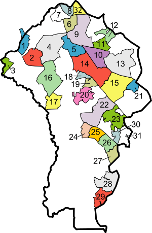
- Bracketed number refers to location on map
City
- Annapolis (23) (county seat)
Town
- Highland Beach (31)
Census-designated places
- Annapolis Neck (30)
- Arden on the Severn (18)
- Arnold (15)
- Brooklyn Park (32)
- Cape Saint Claire (21)
- Crofton (17)
- Crownsville (20)
- Deale (29)
- Edgewater (25)
- Ferndale (6)
- Fort Meade (2)
- Friendship
- Galesville
- Gambrills
- Glen Burnie (9)
- Herald Harbor (19)
- Jessup (1) (partly in Howard County)
- Lake Shore (13)
- Linthicum (7)
- Maryland City (3)
- Mayo (27)
- Naval Academy
- Odenton (16)
- Parole (22)
- Pasadena (10)
- Pumphrey (8)
- Riva (24)
- Riviera Beach (12)
- Selby-on-the-Bay (26)
- Severn (4)
- Severna Park (14)
- Shady Side (28)
- South Gate (5)
Unincorporated communities
- Beverly Beach
- Bristol
- Chestnut Hill Cove
- Churchton
- Davidsonville
- Fairhaven
- Germantown
- Gibson Island
- Green Haven
- Hanover (partly in Howard County)
- Harmans
- Harundale
- Harwood
- Hillsmere Shores
- Jacobsville
- Londontowne (25)
- Lothian
- Millersville
- Orchard Beach
- Owensville
- Riverdale
- Russett
- Sherwood Forest
- Sudley
- Tracys Landing
- Waysons Corner
- West River
- Winchester-on-the-Severn
- Woodland Beach
Notable people
- Steve Bisciotti owner, Baltimore Ravens
- Peter Bondra ice hockey player[47]
- Johns Hopkins philanthropist and founder of Johns Hopkins University[48]
- Ronald Malfi, American author[49]
- Travis Pastrana motosports competitor
- Pat Sajak entertainer[50]
- Jeff Hatch American football player[51]
- Brady Barr herpetologist and television host
- Toni Braxton entertainer[52]
- Tamar Braxton entertainer[53]
- Mark Teixeira baseball player[54]
- Steve Wojciechowski basketball player and coach[55]
References
- "State & County QuickFacts". United States Census Bureau. Archived from the original on June 29, 2011. Retrieved August 20, 2013.
- Odenton Patch Odenton's Population Jumps 17K According to Census. by Tim Lemke, "The western portion of Anne Arundel County saw significant growth, paced by a more than 80 percent jump in residents in Odenton", February 16, 2011, accessed February 17, 2012.
- "Find a County". National Association of Counties. Archived from the original on May 31, 2011. Retrieved June 7, 2011.
- Anne Arundel County Maryland - Our Early Settlers, Maryland Genealogy Trails, accessed April 2018.
- "Maryland Parishes and Hundreds ca 1696". The Combs &c Research Group.
- "History – Seventeenth Century through the Present". Anne Arundel County. Archived from the original on 15 September 2012. Retrieved 30 August 2014.
- Sander, Kathleen Waters (2017-05-25). John W. Garrett and the Baltimore and Ohio Railroad. JHU Press. ISBN 978-1-4214-2220-6.
- Joshua Dorsey Warfield. The founders of Anne Arundel and Howard Counties, Maryland. p. 36.
- "National Register Information System". National Register of Historic Places. National Park Service. April 15, 2008.
- "2010 Census Gazetteer Files". United States Census Bureau. August 22, 2012. Archived from the original on September 13, 2014. Retrieved September 12, 2014.
- "Anne Arundel County". Anne Arundel County. Retrieved 2020-06-20.
- "A History of Brooklyn-Curtis Bay". Archived from the original on 2012-03-16.
- "Anne Arundel County High Point, Maryland".
- "Geological Units in Anne Arundel County, Maryland". U.S. Geological Survey.
- "Magothy Quartzite Quarry". Maryland Historic Trust.
- "Station Name: BALTIMORE WASH INTL AP". National Oceanic and Atmospheric Administration. Retrieved 2014-03-13.
- "Maryland Average Annual Snowfall Map". National Oceanic and Atmospheric Administration.
- "USDA Plant Hardiness Zone Map". USDA. Archived from the original on 27 February 2014. Retrieved 8 February 2013.
- "Maryland Election Results 2016". Retrieved June 6, 2017.
- Davis, Phil (2016-11-09). "After 52 years, Anne Arundel goes for a Democrat — and picks the loser". Capital Gazette. Retrieved 2020-07-23.
- "Precinct Voter Counts Report" (PDF). Anne Arundel County Board of Elections. October 31, 2018. Retrieved December 5, 2018.
- Leip, David. "Dave Leip's Atlas of U.S. Presidential Elections". uselectionatlas.org.
- Anne Arundel County Department of Detention Facilities Archived September 9, 2009, at the Wayback Machine
- "Population and Housing Unit Estimates". Retrieved April 26, 2019.
- "U.S. Decennial Census". United States Census Bureau. Retrieved September 12, 2014.
- "Historical Census Browser". University of Virginia Library. Retrieved September 12, 2014.
- "Population of Counties by Decennial Census: 1900 to 1990". United States Census Bureau. Retrieved September 12, 2014.
- "Census 2000 PHC-T-4. Ranking Tables for Counties: 1990 and 2000" (PDF). United States Census Bureau. Retrieved September 12, 2014.
- "DP-1 Profile of General Population and Housing Characteristics: 2010 Demographic Profile Data". United States Census Bureau. Archived from the original on 2020-02-13. Retrieved 2016-01-22.
- "Population, Housing Units, Area, and Density: 2010 – County". United States Census Bureau. Archived from the original on 2020-02-13. Retrieved 2016-01-22.
- "DP02 SELECTED SOCIAL CHARACTERISTICS IN THE UNITED STATES – 2006–2010 American Community Survey 5-Year Estimates". United States Census Bureau. Archived from the original on 2020-02-13. Retrieved 2016-01-22.
- "DP03 SELECTED ECONOMIC CHARACTERISTICS – 2006–2010 American Community Survey 5-Year Estimates". United States Census Bureau. Archived from the original on 2020-02-13. Retrieved 2016-01-22.
- "U.S. Census website". United States Census Bureau. Retrieved January 31, 2008.
- Major Employers in Anne Arundel County, Maryland, Maryland Department of Business and Economic Development (Oct. 2015 data).
- Bureau, U.S. Census. "American FactFinder - Community Facts". factfinder.census.gov. Archived from the original on 2020-02-11. Retrieved 2009-03-10.
- Home page. Maryland Department of Agriculture. Retrieved on March 23, 2009.
- "Maryland Aviation Administration Contacts." Maryland Aviation Administration. Retrieved on March 2, 2010.
- Home page Archived 2009-04-10 at the Wayback Machine. Maryland Department of Housing and Community Development. Retrieved on March 23, 2009.
- "MDOT Departments Archived 2009-03-21 at the Wayback Machine". Maryland Department of Transportation. Retrieved on March 23, 2009.
- "Contact Us Archived July 23, 2007, at the Wayback Machine". Rural Maryland Council. Retrieved on March 23, 2009.
- "GR2009052900126.gif." The Washington Post. Retrieved on October 7, 2010.
- "Maryland Gazette Collection". Maryland State Archives.
- "Sandy Point State Park". Maryland Department of Natural Resources. Archived from the original on 5 September 2012. Retrieved 12 September 2012.
- "Tawes Garden". Maryland Department of Natural Resources. Archived from the original on 5 September 2012. Retrieved 12 September 2012.
- Maryland Department of Natural Resources (1998). "Trail Management Plan" (PDF).
- "About Us". Anne Arundel County. Archived from the original on 11 September 2012. Retrieved 12 September 2012.
- El-Bashir, Tarik (2005-08-19). "Capitals Re-Sign Forward Dainius Zubrus". The Washington Post.
- Who Was Who in America, Historical Volume, 1607–1896. Chicago: Marquis Who's Who. 1963.
- "Meet Local Author At AACC Literary Discussion". Anne Arundel Community College. April 2007. Archived from the original on July 18, 2010.
- Hermann, Peter. "'Wheel Of Fortune' Host Buys Severna Park Home". baltimoresun.com. The Baltimore Sun.
- "Jeff Hatch". Pro Football Reference. Retrieved 2017-10-11.
- "Toni Braxton's back, with a pretty 'Please'". tribunedigital-baltimoresun. Retrieved 2018-05-29.
- "Tamar Braxton | 107.5 WBLS - #1 FOR R&B". 107.5 WBLS - #1 FOR R&B. Archived from the original on 2018-06-17. Retrieved 2018-05-29.
- "Pinstripe Alley Top 100 Yankees: #78 Mark Teixeira". pinstripealley.com. SBNation. 2015-01-21. Retrieved 2018-08-18.
- "It's homecoming week for Severna Park's Wojciechowski". capitalgazette.com. Retrieved 2018-08-18.
External links
| Wikimedia Commons has media related to Anne Arundel County, Maryland. |
- Official website

- Anne Arundel County Code
- Anne Arundel Elections Statistics
- Annapolis and Anne Arundel County Conference and Visitors Bureau
- Anne Arundel County Business Directory
Places adjacent to Anne Arundel County, Maryland | ||||||||||
|---|---|---|---|---|---|---|---|---|---|---|
| ||||||||||
.svg.png)
| Authority control |
|
|---|