Frederick County, Maryland
Frederick County is located in the northern part of the U.S. state of Maryland. As of the 2010 U.S. Census, the population was 240,336.[1] The county seat is Frederick.[2]
Frederick County, Maryland | |
|---|---|
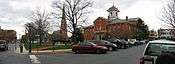
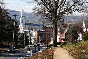
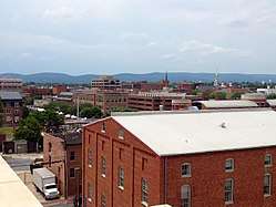 Downtown Frederick in June 2014 | |
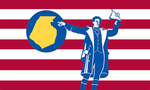 Flag  Seal | |
| Nicknames: "Frederick", "FredCo" | |
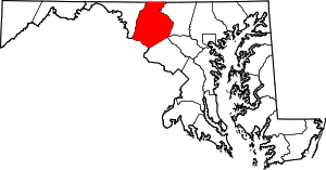 Location in the State of Maryland | |
| Country | |
| State | |
| Founded | June 10, 1748 |
| Seat | Frederick |
| Government | |
| • Executive | Jan Gardner |
| Area | |
| • Total | 1,730 km2 (667 sq mi) |
| • Land | 1,700 km2 (660 sq mi) |
| • Water | 19 km2 (7.2 sq mi) |
| Population (2010) | |
| • Total | 240,336 |
| • Estimate (2019) | 259,547 |
| • Density | 140/km2 (360/sq mi) |
| Time zone | Eastern (EST) |
| • Summer (DST) | EDT |
| ZIP | 21701,21702,21703,21704,21705,21709 |
| Area codes | 301, 240 |
| Congressional districts | 6th, 8th |
| Website | http://www.FrederickCountyMD.gov/ |
Frederick County is included in the Washington-Arlington-Alexandria, DC-VA-MD-WV Metropolitan Statistical Area. Like other outlying sections of the Washington metropolitan area, Frederick County has experienced a rapid population increase in recent years.[3][4] It borders the southern border of Pennsylvania and the northeastern border of Virginia.
The county is home to Catoctin Mountain Park (encompassing the presidential retreat Camp David) and to the U.S. Army's Fort Detrick. Notable persons from here include Francis Scott Key, Chris Rose, Zach Taylor, Matt Bennett, Thomas Johnson, Roger B. Taney, and Barbara Fritchie.
Etymology
The namesake of Frederick County and its county seat is unknown, but it probably was either Frederick, Prince of Wales, or Frederick Calvert, 6th Baron Baltimore.[5]
History
Frederick County was created in 1748 by the Province of Maryland from parts of Prince George's County and Baltimore County.
In 1776 following Independence, Frederick County was divided into three parts. The westernmost portion became Washington County, named after George Washington, the southernmost portion became Montgomery County, named after another Revolutionary War general, Richard Montgomery. The northern portion remained Frederick County.
In 1837 a part of Frederick County was combined with a part of Baltimore County to form Carroll County which is east of current day Frederick County.
The county has a number of properties on the National Register of Historic Places.[6]
Geography
According to the U.S. Census Bureau, the county has a total area of 667 square miles (1,730 km2), of which 660 square miles (1,700 km2) is land and 7.2 square miles (19 km2) (1.1%) is water.[8] It is the largest county in Maryland in terms of land area.[9]
Frederick County straddles the boundary between the Piedmont Plateau Region and the Appalachian Mountains. The county's two prominent ridges, Catoctin Mountain and South Mountain, form an extension of the Blue Ridge. The Middletown Valley lies between them.
Attractions in the Frederick area include the Clustered Spires, a monument to Francis Scott Key, the National Museum of Civil War Medicine, Monocacy National Battlefield and South Mountain battlefields, and the Schifferstadt Architectural Museum.
Adjacent counties
- Adams County, Pennsylvania (north)
- Carroll County (east)
- Howard County (southeast)
- Franklin County, Pennsylvania (northwest)
- Montgomery County (south)
- Washington County (west)
- Loudoun County, Virginia (southwest)
National protected areas
_from_the_overpass_for_Mussetter_Road_in_Linganore%2C_Frederick_County%2C_Maryland.jpg)
Demographics
| Historical population | |||
|---|---|---|---|
| Census | Pop. | %± | |
| 1790 | 30,791 | — | |
| 1800 | 31,523 | 2.4% | |
| 1810 | 34,437 | 9.2% | |
| 1820 | 40,459 | 17.5% | |
| 1830 | 45,789 | 13.2% | |
| 1840 | 36,405 | −20.5% | |
| 1850 | 40,987 | 12.6% | |
| 1860 | 46,591 | 13.7% | |
| 1870 | 47,572 | 2.1% | |
| 1880 | 50,482 | 6.1% | |
| 1890 | 49,512 | −1.9% | |
| 1900 | 51,920 | 4.9% | |
| 1910 | 52,673 | 1.5% | |
| 1920 | 52,541 | −0.3% | |
| 1930 | 54,440 | 3.6% | |
| 1940 | 57,312 | 5.3% | |
| 1950 | 62,287 | 8.7% | |
| 1960 | 71,930 | 15.5% | |
| 1970 | 84,927 | 18.1% | |
| 1980 | 114,792 | 35.2% | |
| 1990 | 150,208 | 30.9% | |
| 2000 | 195,277 | 30.0% | |
| 2010 | 233,385 | 19.5% | |
| Est. 2019 | 259,547 | [10] | 11.2% |
| U.S. Decennial Census[11] 1790-1960[12] 1900-1990[13] 1990-2000[14] 2010–2018[1] | |||
Frederick County has experienced a rapid increase in population in recent years, including that of minority groups.[3][4]
2000 census
The summary statistics for Frederick County from the 2000 U.S. Census are provided to compare and contrast with the more current data from the 2010 Census. The following table includes the total persons, sex and self-designated ethnicity based on 2000 Census; additional details are archived at the Maryland State Government website.
2000 Census total population: 195,277
Male: 96,079 (49.2%) Female: 99,198 (50.8%)
Ethnicity as percent total population: White: 176,965 (90.6%) Black or African American: 13,605 (7.0%) American Indian and Alaskan: 1,083 (0.6%) Asian: 4,066 (2.1%) Native Hawaiian and Other Pacific Islander: 156 (0.1%) Some other ethnicity: 2,434 (1.2%) The total (all races) of those self-identifying as Hispanic or Latino origin made up 2.4%, and those persons who were white alone made up 88.1%.
2010 census
As of the 2010 United States Census, there were 233,385 people, 84,800 households, and 61,198 families residing in the county.[15] The population density was 353.5 inhabitants per square mile (136.5/km2). There were 90,136 housing units at an average density of 136.5 per square mile (52.7/km2).[16] The racial makeup of the county was 81.5% white, 8.6% black or African American, 3.8% Asian, 0.3% American Indian, 2.9% from other races, and 2.8% from two or more races. The total (all races) of those self-identifying as Hispanic or Latino origin made up 7.3%, and those persons who were white alone made up 77.8% of the population.[15] In terms of ancestry, 26.3% were German, 17.4% were Irish, 12.1% were English, 7.2% were Italian, and 6.3% were American.[17]
Of the 84,800 households, 37.6% had children under the age of 18 living with them, 57.8% were married couples living together, 10.0% had a female householder with no husband present, 27.8% were non-families, and 22.0% of all households were made up of individuals. The average household size was 2.70 and the average family size was 3.17. The median age was 38.6 years.[15]
The median income for a household in the county was $81,686 and the median income for a family was $95,036. Males had a median income of $62,494 versus $46,720 for females. The per capita income for the county was $35,172. About 3.2% of families and 4.8% of the population were below the poverty line, including 5.8% of those under age 18 and 5.6% of those age 65 or over.[18]
2014
The United States Census Bureau estimates Frederick County's population at 245,322, marking a 5.1% increase since 2010.[1] The racial makeup was estimated to be the following in 2014: 75% White (47.0% Non-Hispanic White), 9.7% Black, 4.6% Asian, 0.5% Native American, 0.1% Native Hawaiian or Pacific Islander, 2.8% Two or more races, and 8.7% were Hispanic or Latino, of any race.[1]
Religion
Islam
As of 2000, it is estimated that Frederick County has 200 Muslim families.[19] In 2000, the Islamic Society of Frederick planned the construction of a mosque along with a Muslim cemetery, which would be the first mosque in Frederick County and the first Muslim cemetery in Maryland. The land they wanted to build the mosque on, however, was off-limits for development, and their appeal to the county commissioners to connect to the county water and sewer lines was met with a tie vote, barring their ability to build a mosque.[20]
Law, government, and politics
Until 2014, Frederick County was governed by county commissioners, the traditional form of county government in the state of Maryland.
Charter government
Effective December 1, 2014, Frederick County transitioned to a "charter home rule government".[21] The voters approved this governmental change on November 6, 2012 election with 62,469 voting for the transition and 37,368 voting against.[22]
A county executive is responsible for providing direction, supervision, and administrative oversight of all executive departments, agencies, and offices. A county council will also be elected, made up of seven members: five based on district and two at-large.[22]
Jan H. Gardner was elected the first Frederick County Executive in 2014.[23] Gardner was reelected in 2018.[24]
| Name | Affiliation | Term | |
|---|---|---|---|
| Jan H. Gardner | Democrat | 2014— |
The members of the second Frederick County Council for the term beginning 2018 are:[25][26]
| Name | Affiliation | District | Region | First elected | |
|---|---|---|---|---|---|
| Kai Hagen | Democrat | At-large | At-large | 2018 | |
| Phil Dacey | Republican | At-large | At-large | 2018 | |
| Jerry Donald[27] | Democrat | 1 | Braddock Heights, Middletown, Brunswick | 2014 | |
| Steve McKay | Republican | 2 | Monrovia, Urbana, New Market, Mount Airy | 2018 | |
| M.C. Keegan-Ayer | Democrat | 3 | Frederick, Clover Hill | 2014 | |
| Jessica Fitzwater | Democrat | 4 | Frederick, Ballenger Creek, Linganore | 2014 | |
| Michael Blue | Republican | 5 | Myersville, Emmitsburg, Thurmont | 2018 | |
The Frederick County State's Attorney, elected November 2, 2010, is Republican Charlie Smith. Smith was reelected in 2018.[25]
The sheriff of Frederick County is Republican Chuck Jenkins.[25]
The Executive Director for the Frederick County Office of Economic Development is Helen Propheter. The Office of Economic Development is located at 118 North Market Street, Suite 300, Frederick, MD 21701. Phone: 301-600-1037
Frederick County's fire and rescue service is handled by a combination career and volunteer service delivery system. Frederick County employs over 450 career firefighters. Volunteers of the 26 volunteer fire and rescue corporations number approximately 300 active operational members. Fire, Rescue, and Emergency Medical Services, including Advanced Life Support are handled by career staffing supplemented by volunteers. Frederick County has a Maryland State Police Medevac located at the Frederick Municipal Airport and is designated "Trooper 3". Trooper 3 handles calls all throughout the state, but provides immediate assistance to local police, fire and rescue services.
Politics
Frederick is traditionally a strong Republican county. No Democratic presidential candidate has won Frederick County since Lyndon Johnson's 1964 landslide. However, both Barack Obama and Hillary Clinton have come close to reclaiming the county in the past three presidential elections: John McCain won by only 1,157 votes out of over one hundred thousand in the 2008 election.
| Year | Republican | Democratic | Third parties |
|---|---|---|---|
| 2016 | 47.4% 59,522 | 45.0% 56,522 | 7.7% 9,633 |
| 2012 | 50.2% 58,798 | 47.1% 55,146 | 2.7% 3,171 |
| 2008 | 49.6% 55,170 | 48.6% 54,013 | 1.8% 2,003 |
| 2004 | 59.6% 59,934 | 39.3% 39,503 | 1.2% 1,157 |
| 2000 | 57.7% 45,350 | 39.1% 30,725 | 3.3% 2,586 |
| 1996 | 52.8% 34,494 | 38.4% 25,081 | 8.8% 5,728 |
| 1992 | 48.4% 31,290 | 33.8% 21,848 | 17.9% 11,553 |
| 1988 | 65.3% 32,575 | 34.2% 17,061 | 0.5% 231 |
| 1984 | 68.7% 29,606 | 31.1% 13,411 | 0.2% 96 |
| 1980 | 56.3% 22,033 | 34.8% 13,629 | 8.9% 3,468 |
| 1976 | 55.2% 17,941 | 44.8% 14,542 | |
| 1972 | 69.5% 19,907 | 28.7% 8,235 | 1.8% 509 |
| 1968 | 51.9% 13,649 | 31.6% 8,316 | 16.5% 4,348 |
| 1964 | 38.9% 9,264 | 61.1% 14,548 | |
| 1960 | 57.5% 13,408 | 42.5% 9,910 | 0.0% 1 |
| 1956 | 65.4% 14,387 | 34.6% 7,619 | |
| 1952 | 64.9% 14,562 | 35.0% 7,851 | 0.2% 38 |
| 1948 | 57.8% 9,934 | 41.5% 7,142 | 0.7% 121 |
| 1944 | 57.1% 11,367 | 42.9% 8,528 | |
| 1940 | 48.0% 10,485 | 51.6% 11,255 | 0.4% 93 |
| 1936 | 46.8% 9,500 | 52.9% 10,722 | 0.3% 64 |
| 1932 | 39.6% 7,144 | 59.3% 10,686 | 1.1% 194 |
| 1928 | 62.6% 12,569 | 36.9% 7,406 | 0.6% 114 |
| 1924 | 49.4% 8,441 | 45.3% 7,740 | 5.4% 925 |
| 1920 | 54.6% 9,559 | 44.2% 7,747 | 1.2% 212 |
| 1916 | 47.6% 5,725 | 50.7% 6,094 | 1.7% 207 |
| 1912 | 24.8% 2,813 | 48.8% 5,545 | 26.4% 3,002 |
| 1908 | 52.7% 5,966 | 45.6% 5,158 | 1.7% 192 |
| 1904 | 52.8% 5,788 | 45.7% 5,004 | 1.5% 164 |
| 1900 | 51.3% 6,391 | 46.7% 5,820 | 2.0% 246 |
In state-level elections, Republicans in Frederick rebounded to more historical levels in the 2010 Maryland Gubernatorial & Senatorial Elections, giving the Republican Ehrlich/Kane ticket 55% to Democrat O'Malley/Brown's 45. Frederick voters also supported Republican Senate challenger Eric Wargotz over incumbent Democratic Senator Barbara Mikulski by a margin of 51–46, even as Mikulski was winning statewide by a landslide 61–37. Despite its conservative reputation, Frederick County voted in favor of Maryland Question 6, which legalized same-sex marriage in Maryland. In the 2014 Maryland Gubernatorial race Republican Larry Hogan won Frederick County strongly with 63 percent of the vote compared to Democrat Anthony Brown's 35 percent.[29] In the 2018 elections, despite increased support for Hogan, the Democrats experienced significant gains, securing a majority on the County Council and winning District 3B in the House of Delegates.[30][31][32] The election also saw incumbent U.S. Senator Ben Cardin win Frederick County with 51.7% of the vote.[33]
Public safety
The Frederick County Sheriff's Office provides court protection, jail management, and morgue operation for the entire county. It provides police patrol and detective services within the unincorporated areas of Frederick County. The entire county entails a population of 222,938 residents within 662.88 square miles (1,717 km2). Frederick City, Brunswick, Mt.Airy, Emmitsburg, and Thurmont have municipal police departments. Middletown contracts with the Sheriff's Office for its policing.[34]
Crime
The following table includes the number of incidents reported for each type of offense.
| Crimes and incidents reported[35] | |
|---|---|
| Population[36] | 245,322 |
| Homicide (criminal and non-criminal) | 1 |
| Forcible rape | 61 |
| Assault (aggravated and simple) | 30 |
| Robbery | 23 |
| Burglary | 169 |
| Theft | 161 |
| Motor Vehicle Theft | 3 |
| Fraud | 42 |
| Arson | 9 |
Economy
The United States Census Bureau has reported the following data for Frederick County.[37]
| Metric | Frederick County | Maryland |
|---|---|---|
| Per capita money income in past 12 months (2013 dollars), 2009-2013 | $36,917 | $36,354 |
| Median household income, 2009-2013 | $84,570 | $73,538 |
| Persons below poverty level, percent, 2009-2013 | 6.1% | 9.8% |
| Private nonfarm establishments, 2013 | 5,955 | 135,4211 |
| Private nonfarm employment, 2013 | 83,799 | 2,182,2601 |
| Private nonfarm employment, percent change, 2012-2013 | 1.1% | 1.4% |
| Nonemployer establishments, 2012 | 16,843 | 442,314 |
| Total number of firms, 2007 | 21,430 | 528,112 |
| Black-owned firms, percent | 5.9% | 19.3% |
| Asian-owned firms, percent | 3.3% | 6.8% |
| Hispanic-owned firms, percent, 2007 | 3.6% | 4.9% |
| Women-owned firms | 31.1% | 32.6% |
| Manufacturers shipments, 2007 ($1000) | 3,003,696 | 41,456,097 |
| Merchant wholesaler sales, 2007 ($1000) | 1,252,142 | 51,276,797 |
| Retail sales, 2007 ($1000) | 3,066,281 | 75,664,186 |
| Retail sales per capita, 2007 | $13,629 | $13,429 |
| Accommodation and food services sales, 2007 ($1000) | 356,482 | 10,758,428 |
| Building permits, 2013 | 1,220 | 17,918 |
According to the Maryland Department of Business and Economic Development, the following are the principal employers in Frederick County. This list excludes U.S. post offices and state and local governments, but includes public institutions of higher education.[38]
| Employer | Employees (Nov. 2014)[38] |
|---|---|
| Fort Detrick (including Frederick National Laboratory for Cancer Research) |
4,600 |
| Frederick Memorial Healthcare System | 2,696 |
| Wells Fargo Home Mortgage | 1,881 |
| Leidos Biomedical Research | 1,836 |
| Bechtel | 1,578 |
| Frederick Community College | 1,055 |
| State Farm Insurance | 900 |
| Walmart/Sam's Club | 700 |
| AstraZeneca | 595 |
| Lonza Walkersville | 520 |
| Hood College | 519 |
| Mount St. Mary's University | 511 |
| UnitedHealthcare | 500 |
| McDonald's | 499 |
| Giant Food | 490 |
| Way Station | 480 |
| Costco Wholesale | 452 |
| Life Technologies | 450 |
| NVR | 450 |
| Wegmans Food Markets | 445 |
| Home Depot | 444 |
| Plamondon Companies | 400 |
| Stulz Air Technology Systems | 375 |
| Weis Markets | 363 |
| RR Donnelley | 359 |
| YMCA of Frederick County | 350 |
| Canam Steel | 333 |
| Giant Eagle | 330 |
| Homewood Retirement Centers | 300 |
| Toys "R" Us | 260 |
| Trans-Tech | 260 |
Frederick County leads Maryland in milk production; the county's dairy herds account for one-third of the state's total.[39] However, the dairy market is unstable, and the Frederick County, like the state more broadly, has lost dairy farms.[40]
Communities
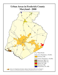
Towns
Village
Census-designated places
The Census Bureau recognizes the following census-designated places in the county:
Unincorporated communities
Notable people
- Shadrach Bond, first governor of Illinois (1818-1822)
- Francis Scott Key, wrote U.S. national anthem, "The Star-Spangled Banner"
Notes
- "Frederick County QuickFacts". U.S. Census Bureau. 2010. Archived from the original on June 6, 2011. Retrieved August 1, 2011.
- "Find a County". National Association of Counties. Archived from the original on May 31, 2011. Retrieved June 7, 2011.
- "Population Change in Suburban Maryland" (PDF). George Mason University. Retrieved February 16, 2014.
- "Metropolitan sprawl puts urban in suburban". 2012. Retrieved February 16, 2014.
- "Frederick County, Maryland – Government". Maryland State Archives. March 5, 2008. Retrieved August 16, 2008.
- "National Register Information System". National Register of Historic Places. National Park Service. April 15, 2008.
- "Washington-Arlington-Alexandria, DC-VA-MD-WV". U.S. Census Bureau. U.S. Department of Commerce. Retrieved April 12, 2017.
- "2010 Census Gazetteer Files". United States Census Bureau. August 22, 2012. Archived from the original on September 13, 2014. Retrieved September 12, 2014.
- "Frederick News-Post Local Section". The Frederick News-Post. Archived from the original on March 16, 2007. Retrieved March 16, 2007.
- "Population and Housing Unit Estimates". Retrieved April 26, 2019.
- "U.S. Decennial Census". United States Census Bureau. Retrieved September 12, 2014.
- "Historical Census Browser". University of Virginia Library. Retrieved September 12, 2014.
- "Population of Counties by Decennial Census: 1900 to 1990". United States Census Bureau. Retrieved September 12, 2014.
- "Census 2000 PHC-T-4. Ranking Tables for Counties: 1990 and 2000" (PDF). United States Census Bureau. Retrieved September 12, 2014.
- "DP-1 Profile of General Population and Housing Characteristics: 2010 Demographic Profile Data". United States Census Bureau. Archived from the original on February 13, 2020. Retrieved January 22, 2016.
- "Population, Housing Units, Area, and Density: 2010 - County". United States Census Bureau. Archived from the original on February 13, 2020. Retrieved January 22, 2016.
- "DP02 SELECTED SOCIAL CHARACTERISTICS IN THE UNITED STATES – 2006-2010 American Community Survey 5-Year Estimates". United States Census Bureau. Archived from the original on February 13, 2020. Retrieved January 22, 2016.
- "DP03 SELECTED ECONOMIC CHARACTERISTICS – 2006-2010 American Community Survey 5-Year Estimates". United States Census Bureau. Archived from the original on February 13, 2020. Retrieved January 22, 2016.
- Daemmrich, JoAnna (August 25, 2000). "Frederick's Muslims make plea for mosque". The Baltimore Sun. Retrieved March 9, 2020.
- Daemmrich, JoAnna (August 24, 2000). "Hopes for Frederick mosque stir debate". The Baltimore Sun. Retrieved March 10, 2020.
- "Charter Government Transition". Frederick County, MD Government. Archived from the original on March 7, 2014. Retrieved March 7, 2014.
- Depies, Lori (March 18, 2013). "Charter Government and Transition: What it means to you and to Frederick County" (PDF). Archived from the original (PDF) on March 7, 2014. Retrieved March 7, 2014.
- McManus, Kevin (November 5, 2014). "Gardner Elected Frederick County's First Executive". WFMD-AM. Frederick, Maryland: Aloha Station Trust, LLC. Archived from the original on November 8, 2014.
- "2018 county election results in Maryland". WTOP. November 7, 2018.
- "Election Summary Report Gubernatorial General Election, Frederick County, Maryland, November 4, 2014: Summary For Jurisdiction Wide, All Counters, All Races, Unofficial Results, Early Voting, Polling Place, and Absentee 1 Canvass" (PDF). Frederick County Board of Elections. November 6, 2014. Archived from the original (PDF) on November 8, 2014.
- "2014 Council Districts" (PDF). Frederick County Board of Elections. November 19, 2013. Archived from the original (pdf) on March 5, 2014.
- Rodgers, Bethany (November 15, 2014). "Donald takes County Council seat by 25 votes". Frederick News-Post. Retrieved November 15, 2014.
- Leip, David. "Dave Leip's Atlas of U.S. Presidential Elections". uselectionatlas.org. Retrieved June 11, 2018.
- http://www.frederickcountymd.gov/DocumentCenter/View/277460
- "2018 Maryland Election Results: Governor's race, statewide offices". WTOP. November 6, 2018. Retrieved August 28, 2019.
- "2018 county election results in Maryland". WTOP. November 7, 2018. Retrieved August 28, 2019.
- "2018 Maryland House of Delegates Election Results". WTOP. November 6, 2018. Retrieved August 28, 2019.
- "Maryland Election Results 2018: Live Midterm Map by County & Analysis". www.politico.com. Retrieved August 28, 2019.
- Frederick County Sheriff office website
- "2014 Annual Report". Frederick County Sheriff. Retrieved August 24, 2016.
- "Population estimates, July 1, 2015, (V2015)". www.census.gov. Retrieved August 24, 2016.
- State & County QuickFacts, Frederick County Archived June 6, 2011, at the Wayback Machine, Maryland, United States Census Bureau.
- Major Employers in Frederick County, Maryland, Maryland Department of Business and Economic Development.
- Maryland at a Glance: Agriculture, Maryland Manual (April 2015).
- Associated Press, Frederick County Dairy Farm Closes Its Doors (October 1, 2012).
References
- "Major Frederick County Employers". Frederick County Office of Economic Development. Archived from the original on July 2, 2007. Retrieved May 25, 2007.
- The newspaper of record is The Frederick News-Post.
- Fire Rescue Information: Frederick County Volunteer Fire Rescue Association
External links
| Wikimedia Commons has media related to Frederick County, Maryland. |
- Official website
- Frederick County Public Schools (FCPS)
- Frederick County Public Libraries (FCPL)
- Frederick County Tourism
- Frederick County, Maryland at Curlie
- Frederick County Restaurants
- Frederick County Board of County Commissioners
- Convention and Visitors Bureau
Places adjacent to Frederick County, Maryland | |
|---|---|
Municipalities and communities of Frederick County, Maryland, United States | ||
|---|---|---|
| Cities | | |
| Towns | ||
| Village | ||
| CDPs | ||
| Other communities |
| |
| Footnotes | ‡This populated place also has portions in an adjacent county or counties | |
.svg.png)
| Principal cities (and city-like entities) |
|   | |||||||
|---|---|---|---|---|---|---|---|---|---|
| Counties (and county equivalents) |
| ||||||||
The District of Columbia itself, and Virginia's incorporated cities, are county equivalents. Virginia's incorporated cities are listed under their surrounding county. The incorporated cities bordering more than one county (Alexandria, Falls Church and Fredericksburg) are listed under the county they were part of before incorporation as a city. Some unincorporated areas and census-designated places like Silver Spring and Bethesda in Maryland, Reston in Virginia, as well as the County of Arlington in Virginia are also treated as city-like entities (or principal cities) even though they have not been legally incorporated as such. | |||||||||
| Authority control |
|
|---|