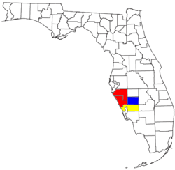
Sarasota metropolitan area
The Sarasota metropolitan area is a metropolitan area located in Southwest Florida. The metropolitan area is defined by the Office of Management and Budget as the North Port–Sarasota–Bradenton metropolitan statistical area as a metropolitan statistical area (MSA) consisting of Manatee County and Sarasota County.[1] The largest cities in the MSA are North Port and Sarasota (both in Sarasota County) and Bradenton (in Manatee County). At the 2010 Census, the MSA had a population of 702,281. The Census Bureau estimates that its population was 821,573 in 2018.[2]
Sarasota metropolitan area | |
|---|---|
| North Port–Sarasota–Bradenton metropolitan area | |
| |
| Country | United States |
| State(s) | Florida |
| Largest city | North Port |
| Other cities | |
| Area | |
| • Total | 1,295.8 sq mi (3,356 km2) |
| Population (2010) | |
| • Total | 702,281 |
| • Rank | 72nd in the U.S. |
| • Density | 542.0/sq mi (209.3/km2) |
Additionally, the federal government defines the North Port–Sarasota combined statistical area as a combined statistical area (CSA) consisting of the combination of the North Port–Sarasota–Bradenton MSA, the Punta Gorda, Florida MSA (Charlotte County), and the Arcadia, Florida, micropolitan statistical area (DeSoto County). At the 2010 Census, the CSA had a population of 897,121. The Census Bureau estimates that its population was 1,044,060 in 2018.[3]
History of the metropolitan area designations
The Sarasota standard metropolitan statistical area (SMSA) was first defined in 1973, and included only Sarasota County. The Bradenton SMSA was defined after the 1980 United States Census, and included only Manatee County. The two MSAs were combined in 1993 as the Sarasota–Bradenton metropolitan statistical area. Venice was added as a principal city after the 2000 census. In 2007, the MSA was renamed the Bradenton–Sarasota–Venice MSA because Bradenton's population then exceeded that of Sarasota.[4] In 2009, the area was designated the North Port–Bradenton–Sarasota MSA after North Port qualified as a "principal city" under the metropolitan statistical area definition and was determined to be the largest of the area's three principal cities.[5] As of 2013, the MSA is named the North Port–Sarasota–Bradenton metropolitan statistical area.[6]
The North Port–Sarasota–Bradenton MSA is a component of the larger North Port–Sarasota combined statistical area, which also includes the Punta Gorda, Florida, MSA and the Arcadia, Florida, micropolitan statistical area.[6]
Demographics
| Historical population | |||
|---|---|---|---|
| Census | Pop. | %± | |
| 1960 | 146,063 | — | |
| 1970 | 217,528 | 48.9% | |
| 1980 | 350,693 | 61.2% | |
| 1990 | 489,483 | 39.6% | |
| 2000 | 589,959 | 20.5% | |
| 2010 | 702,281 | 19.0% | |
| Est. 2019 | 836,995 | 19.2% | |
| source:[7][8]
At the 2010 census, the MSA had a population of 702,281,[9] a 19% increase over the 2000 census population of 589,959.[10] | |||
Counties
| County | 2000 Population |
2010 Population |
2018 Estimated (2010 to 2018) |
% change (2010 to 2018) |
|---|---|---|---|---|
| Sarasota County | 325,957 | 379,448 | 426,718 | +12.46% |
| Manatee County | 264,002 | 322,833 | 394,855 | +22.31% |
| Charlotte County | 141,627 | 159,978 | 184,998 | +15.64% |
| DeSoto County | 32,209 | 34,862 | 37,489 | +7.54% |
| Metropolitan statistical area[lower-alpha 1] | 702,281 | 821,573 | +16.99% | |
| Combined statistical area[lower-alpha 2] | 897,121 | 1,044,060 | +16.38% | |
- Population of Sarasota County and Manatee County combined.
- Population of Sarasota, Manatee, Charlotte, and DeSoto counties combined.
Cities
Largest cities
The following is a list of the five largest cities in the Sarasota metropolitan area as ranked by population.[11]
| Rank | City | County | 2000 Population |
2010 Population |
2018 Estimated (2010 to 2018) |
% change (2010 to 2018) |
|---|---|---|---|---|---|---|
| 1 | North Port | Sarasota | 22,797 | 57,357 | 68,628 | +19.65% |
| 2 | Sarasota | Sarasota | 52,715 | 51,917 | 57,738 | +11.21% |
| 3 | Bradenton | Manatee | 49,504 | 49,546 | 57,644 | +16.34% |
| 4 | Venice | Sarasota | 17,764 | 20,748 | 23,376 | +12.67% |
| 5 | Palmetto | Manatee | 12,571 | 12,606 | 13,717 | +8.81% |
Other cities and towns
| Rank | City | County | 2000 Population |
2010 Population |
2018 Estimated (2010 to 2018) |
% change (2010 to 2018) |
|---|---|---|---|---|---|---|
| 1 | Longboat Key | Sarasota Manatee | 7,603 | 6,888 | 7,292 | +5.87% |
| 2 | Holmes Beach | Manatee | 4,966 | 3,836 | 4,261 | +11.08% |
| 3 | Anna Maria | Manatee | 1,814 | 1,503 | 1,725 | +14.77% |
| 4 | Bradenton Beach | Manatee | 1,482 | 1,171 | 1,269 | +8.37% |
Census Designated Places
The following is a list of census-designated places (CDPs) ranked by population. CDPs in the combined statistical area are included.[12]
| Rank | CDP | County | 2010 Population |
2017 Estimated (2010 to 2017) |
|---|---|---|---|---|
| 1 | Port Charlotte | Charlotte | 54,392 | 59,654 |
| 2 | South Bradenton | Manatee | 22,178 | 24,935 |
| 3 | Bayshore Gardens | Manatee | 16,323 | 20,047 |
| 4 | Sarasota Springs | Sarasota | 14,395 | 16,386 |
| 5 | Englewood | Sarasota
Charlotte |
14,863 | 15,159 |
| 6 | South Venice | Sarasota | 13,949 | 14,535 |
| 7 | Fruitville | Sarasota | 13,224 | 13,541 |
| 8 | Gulf Gate Estates | Sarasota | 10,911 | 10,650 |
| 9 | Bee Ridge | Sarasota | 9,598 | 9,772 |
| 10 | Laurel | Sarasota | 8,171 | 9,283 |
| 11 | Rotonda West | Charlotte | 8,759 | 8,981 |
| 12 | Memphis | Manatee | 7,848 | 8,926 |
| 13 | North Sarasota | Sarasota | 6,982 | 8,728 |
| 14 | Venice Gardens | Sarasota | 7,104 | 7,904 |
| 15 | Southeast Arcadia | Desoto | 6,554 | 7,653 |
| 16 | Southgate | Sarasota | 7,173 | 7,539 |
| 17 | Osprey | Sarasota | 6,100 | 6,734 |
| 18 | Siesta Key | Sarasota | 6,565 | 5,850 |
| 19 | Warm Mineral Springs | Sarasota | 5,061 | 5,305 |
| 20 | South Sarasota | Sarasota | 4,950 | 5,265 |
| 21 | Plantation | Sarasota | 4,919 | 4,790 |
| 22 | Lake Sarasota | Sarasota | 4,679 | 4,718 |
| 23 | The Meadows | Sarasota | 3,994 | 4,383 |
| 24 | Kensington Park | Sarasota | 3,901 | 4,351 |
| 25 | Vamo | Sarasota | 4,727 | 4,345 |
| 26 | Cortez | Manatee | 4,241 | 4,332 |
| 27 | West Bradenton | Manatee | 4,192 | 4,213 |
| 28 | Samoset | Manatee | 3,854 | 3,922 |
| 29 | Ridge Wood Heights | Manatee | 4,795 | 3,878 |
| 30 | Desoto Lakes | Sarasota | 3,646 | 3,590 |
| 31 | Ellenton | Manatee | 4,275 | 3,423 |
| 32 | Harbour Heights | Charlotte | 2,987 | 3,401 |
| 33 | Nokomis | Sarasota | 3,167 | 3,376 |
| 34 | Cleveland | Charlotte | 2,990 | 3,317 |
| 35 | Whitfield | Manatee | 2,882 | 3,215 |
| 36 | Charlotte Park | Charlotte | 2,325 | 2,058 |
| 37 | Grove City | Charlotte | 1,804 | 2,042 |
| 38 | Solana | Charlotte | 742 | 706 |
| 39 | Gardner | Desoto | 463 | 228 |
Climate
The Sarasota metropolitan area, like most of Florida, is located in the humid subtropical zone (Köppen climate classification:Cfa).[13] There are hot, humid summers with frequent afternoon thunderstorms and relatively drier and mild winters.
Transportation
Roads
Freeways
U.S Highways
State Roads
Ports
Public Airports
Public Transportation
Both Sarasota and Manatee counties have their own transit networks, SCAT and MCAT, which runs bus services in the area.[14][15] Amtrak does operate a Thruway Route going through the area starting in St.Petersburg-Clearwater and ending in Fort Myers, with Sarasota and Ellenton operating as stops along the route.[16]
Media
Newspapers
- Anna Maria Island Sun[17]
- Bradenton Herald
- Business Observer, a business newspaper that is published in Sarasota, but serves several other regions of Florida.[18]
- East County Observer[19]
- Longboat Observer
- The Bradenton Times, an online newspaper.[20]
- The Islander[21]
- Sarasota Herald-Tribune
- Siesta Key Observer
- Sarasota Observer
- Tempo News[22]
- Venice Gondolier Sun[23]
Television
Education
Public education is provided by Manatee County School District and Sarasota County Public Schools.[26][27]
Colleges and Universities
The following college/university campuses exist in the metropolitan area.
Economy
The Sarasota Metropolitan Area has a gross metropolitan product of $34.3 billion as of 2018.[28]
Recreation & Culture
See also
- Manatee County, Florida
- Sarasota County, Florida
- Southwest Florida
- Tampa Bay Area
References
- "OMB Bulletin No. 18-04" (PDF). Office of Management and Budget. September 14, 2018. p. 65. Retrieved December 31, 2018.
- "Cumulative Estimates of Resident Population Change and Rankings: April 1, 2010 to July 1, 2018". U.S. Census Bureau, Population Division. March 2018. Archived from the original on February 13, 2020. Retrieved April 18, 2019.
- "Annual Estimates of the Resident Population: April 1, 2010 to July 1, 2018 - United States -- Combined Statistical Area; and for Puerto Rico". U.S. Census Bureau, Population Division. March 2018. Archived from the original on February 13, 2020. Retrieved April 18, 2019.
- "Update of Statistical Area Definitions and Guidance on Their Uses (OMB Bulletin 08 - 01)" (PDF). Office of Management and Budget, Executive Office of the President. November 20, 2007. Archived from the original (CSV) on November 17, 2008. Retrieved November 19, 2008.
- "Update of Statistical Area Definitions and Guidance on Their Uses (OMB Bulletin 10-02)" (PDF). Office of Management and Budget, Executive Office of the President. December 2, 2009. Archived from the original (PDF) on March 16, 2012.
- "Revised Delineations of Metropolitan Statistical Areas, Micropolitan Statistical Areas, and Combined Statistical Areas, and Guidance on Uses of the Delineations of These Areas (OMB Bulletin 13-01)" (PDF). Office of Management and Budget, Executive Office of the President. February 28, 2013.
- "Census of Population and Housing". U.S. Census Bureau. Retrieved January 15, 2019.
- "Cumulative Estimates of Resident Population Change and Rankings for Metropolitan Statistical Areas in the United States and Puerto Rico: April 1, 2010 to July 1, 2019" (PDF). United States Census Bureau. Retrieved May 31, 2020.
- "Table 1. Annual Estimates of the Population of Metropolitan and Micropolitan Statistical Areas: April 1, 2010 to July 1, 2012 (CBSA-EST2012-01)". United States Census Bureau, Population Division. March 2013. Archived from the original (CSV) on July 4, 2013. Retrieved August 4, 2013.
- "Table 1. Annual Estimates of the Population of Metropolitan and Micropolitan Statistical Areas: April 1, 2000 to July 1, 2009 (CBSA-EST2009-01)". 2009 Population Estimates. United States Census Bureau, Population Division. March 23, 2010. Archived from the original (CSV) on March 26, 2010. Retrieved March 24, 2010.
- "Annual Estimates of the Resident Population: April 1, 2010 to July 1, 2018". Census Bureau. May 2019. Archived from the original on February 16, 2020. Retrieved May 24, 2019.
- "U.S. Census website". United States Census Bureau. U.S. Census Bureau. Retrieved March 25, 2019.
- "World Map of the Köppen-Geiger climate classification updated". University of Veterinary Medicine Vienna. November 6, 2008. Retrieved September 10, 2010.
- "SCAT Bus Service | Sarasota County, FL". www.scgov.net. Retrieved January 1, 2019.
- "MCAT". Archived from the original on April 2, 2017. Retrieved January 1, 2019.
- Amtrak, Travel Planning Map. "Travel Planning Map| Amtrak". Amtrak.com.
- "Front Page". Anna Maria Island Sun. Retrieved February 2, 2019.
- "Home Page". Business Observer. Retrieved February 1, 2019.
- "East County". Your Observer. November 24, 2014. Retrieved February 1, 2019.
- "Headlines The Bradenton Times News Headlines". thebradentontimes.com. Retrieved February 1, 2019.
- "Anna Maria Island News | The Anna Maria Island Islander – "The Award Winning & Best News on Anna Maria Island, FL Since 1992"". Retrieved February 2, 2019.
- "About – Tempo News". November 29, 2018. Retrieved October 14, 2019.
- Newspapers, Sun. "Venice Gondolier Sun". Sun Newspapers. Retrieved October 14, 2019.
- "Sarasota Magazine". Sarasota Magazine. Retrieved May 26, 2019.
- "About SRQ Magazine, : Sarasota's Premier Magazine - Staff Page". www.srqmagazine.com. Retrieved May 26, 2019.
- "School District of Manatee County / Homepage". School District of Manatee County. Retrieved October 19, 2019.
- "Sarasota County Schools / Homepage". Sarasota County Schools / Homepage. Retrieved October 19, 2019.
- "Regional Data: GDP and Personal Income". U.S Bureau of Economic Analysis. Retrieved December 19, 2019.
External links
- Metropolitan and micropolitan statistical area definitions