Harrisburg–Carlisle metropolitan statistical area
The Harrisburg–Carlisle, Pennsylvania, metropolitan statistical area is defined by the United States Census Bureau as an area consisting of three counties in Pennsylvania's Susquehanna Valley, anchored by the cities of Harrisburg and (to a lesser-extent) Carlisle. As of the 2010 census, the metropolitan statistical area (MSA) had a population of 549,475. In 2009, Harrisburg–Carlisle was the 96th largest metropolitan area in the United States. As of 2010, it is part of the defined Harrisburg–York–Lebanon, PA Combined Statistical Area, which includes York and Adams counties and has a population of 1,233,708 people making it the 43rd most populous in the United States.
Harrisburg–Carlisle, Pennsylvania MSA Susquehanna Valley Metropolitan Statistical Area | |
|---|---|
    | |
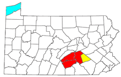 Map of the Harrisburg–Carlisle–Lebanon CSA, composed of the following parts:
Harrisburg–Carlisle metropolitan statistical area
Lebanon metropolitan statistical area | |
| Coordinates: 40.27°N 76.87°W | |
| Country | United States |
| Commonwealth | Pennsylvania |
| Largest city | Harrisburg |
| Other cities | List
|
| Population (2010 Estimate) | |
| • Total | 549,475 CSA: 1,228,559 (49th) |
| Time zone | UTC-5 (ET) |
| • Summer (DST) | UTC-4 (EDT) |
Metro history
- 1950: The Harrisburg standard metropolitan area (SMA), consisting of Cumberland and Dauphin counties, was first defined.[1]
- 1959: Following a term change by the Bureau of the Budget (present-day Office of Management and Budget), the Harrisburg SMA became the Harrisburg standard metropolitan statistical area (SMSA).[2]
- 1963: Perry County added to the Harrisburg SMSA.[3]
- 1983: Harrisburg SMSA renamed the Harrisburg–Lebanon–Carlisle metropolitan statistical area (MSA);[2] Lebanon County added to the MSA.[4]
- 2003: MSA split into two separate metropolitan areas – Harrisburg–Carlisle metropolitan statistical area (Cumberland, Dauphin, and Perry counties) and the Lebanon metropolitan statistical area (Lebanon County);[5] Both MSAs together form the Harrisburg–Carlisle–Lebanon combined statistical area.
- 2010: The Harrisburg–York–Lebanon urban agglomeration area is defined for the first time, linking York County to the CSA.[6]
- 2012: The Harrisburg–York–Lebanon, PA Combined Statistical Area was formally defined and includes the counties of York and Adams.[7]
Demographics
As of the census[8] of 2000, there were 509,074 people, 202,380 households, and 134,557 families residing within the MSA. The racial makeup of the MSA was 86.20% White, 9.39% African American, 0.15% Native American, 1.68% Asian, 0.03% Pacific Islander, 1.17% from other races, and 1.37% from two or more races. Hispanic or Latino of any race were 2.67% of the population.
The median income for a household in the MSA was $43,374, and the median income for a family was $51,792. Males had a median income of $36,368 versus $26,793 for females. The per capita income for the MSA was $21,432.
In 2009 the urban population of the MSA increased to 383,008 from 362,782 in 2000, a change of 20,226 people.[9]
Combined statistical area
The Harrisburg–York–Lebanon, PA Combined Statistical Area (CSA) is made up of six counties. The statistical area includes four metropolitan areas. As of the 2010 Census, the CSA had a population of 1,219,422.[10] The CSA ranked 5th in the state of Pennsylvania, and 43rd most populous in the United States.
Components
- Combined Statistical Areas (CSAs)
- Gettysburg, PA Metropolitan Statistical Area
- Harrisburg-Carlisle, PA Metropolitan Statistical Area
- Lebanon, PA Metropolitan Statistical Area
- York-Hanover, PA Metropolitan Statistical Area
- Metropolitan Statistical Areas (MSAs)
- Harrisburg–Carlisle (Cumberland, Dauphin, and Perry counties)
- Lebanon (Lebanon County)
Demographics
As of the census[8] of 2000, there were 629,401 people, 248,931 households, and 167,328 families residing within the CSA. The racial makeup of the CSA was 87.78% White, 7.84% African American, 0.14% Native American, 1.53% Asian, 0.03% Pacific Islander, 1.38% from other races, and 1.29% from two or more races. Hispanic or Latino of any race were 3.11% of the population.
The median income for a household in the CSA was $42,740, and the median income for a family was $51,071. Males had a median income of $35,660 versus $26,116 for females. The per capita income for the CSA was $21,017.
Population
| Geographic Area | July 1, 2005 | 2000 Census | 1990 Census | 1980 Census | 1970 Census |
|---|---|---|---|---|---|
| Harrisburg–Carlisle–Lebanon, PA CSA | 647,390 | 629,401 | 587,986 | 556,242 | 510,170 |
| Cumberland County, Pennsylvania | 223,089 | 213,674 | 195,257 | 178,541 | 158,177 |
| Dauphin County, Pennsylvania | 253,995 | 251,798 | 237,813 | 232,317 | 223,834 |
| Lebanon County, Pennsylvania | 125,578 | 120,327 | 113,744 | 108,582 | 99,665 |
| Perry County, Pennsylvania | 44,728 | 43,602 | 41,172 | 35,830 | 28,615 |
Urban agglomeration area
In 2010, the Harrisburg area was combined with York and Lebanon as an urban agglomeration, or a contiguous area of continuously developed urban land,[6][11] signifying a future merger with the York–Hanover MSA, which created a combined statistical area of over 1.2 million people.
See also
- Harrisburg–York–Lebanon, PA Combined Statistical Area
- Pennsylvania census statistical areas
- List of Pennsylvania metropolitan areas
- List of United States metropolitan areas
- List of United States combined statistical areas
References
- "Standard Metropolitan Areas (SMAs) and Components" (TXT). Standard Metropolitan Areas defined by the Bureau of the Budget, October 13, 1950. United States Census Bureau, Population Division. December 14, 2000. Retrieved October 20, 2008.
- "About Metropolitan and Micropolitan Statistical Areas". United States Census Bureau, Population Division. Retrieved October 20, 2008.
- "Standard Metropolitan Statistical Areas (SMSAs) and Components, 1963" (TXT). Standard Metropolitan Statistical Areas defined by Office of Management and Budget, October 18, 1963. United States Census Bureau, Population Division. October 25, 2000. Retrieved October 20, 2008.
- "Metropolitan Areas and Components, 1983" (TXT). Metropolitan Statistical Areas defined by Office of Management and Budget, June 27, 1983. United States Census Bureau, Population Division. March 1, 2001. Retrieved October 20, 2008.
- "Metropolitan Statistical Areas and Components, 2003" (TXT). Metropolitan statistical areas defined by Office of Management and Budget, June 6, 2003. United States Census Bureau, Population Division. July 10, 2003. Retrieved October 20, 2008.
- America's Urban Agglomerations 2010 Proximity, Retrieved January 21, 2011.
- Harrisburg-York-Lebanon, PA Combined Statistical Area United States Census Bureau, Retrieved April 2, 2015.
- "U.S. Census website". United States Census Bureau. Retrieved January 31, 2008.
- America's Urban Population: Patterns & Characteristics 2000-2009 Proximity, 2009 data, Retrieved January 21, 2011.
- https://www.census.gov/2010census/
- Differences between the Proposed 2010 Census Urban Area Criteria and the Census 2000 Urban Area Criteria United States Census Bureau, 2010. Retrieved January 21, 2011.
External links
| Wikivoyage has a travel guide for Harrisburg. |
- PA MSA 1990 Census and 1994 Population Estimates
- Quickfacts from U.S. Census Bureau
- census.gov Population of Counties by Decennial Census: 1900 to 1990
Susquehanna Valley | ||
|---|---|---|
| Principal City | | |
| Major East Shore suburbs | ||
| Major West Shore suburbs | ||
| Counties | ||
City of Harrisburg | |
|---|---|
| |
|
Municipalities and communities of Cumberland County, Pennsylvania, United States | ||
|---|---|---|
| Boroughs | 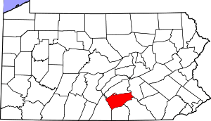 | |
| Townships | ||
| CDPs | ||
| Unincorporated communities | ||
| Footnotes | ‡This populated place also has portions in an adjacent county or counties | |
Municipalities and communities of Dauphin County, Pennsylvania, United States | ||
|---|---|---|
| City | 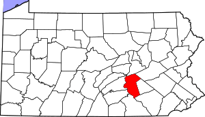 | |
| Boroughs | ||
| Townships | ||
| CDPs | ||
| Unincorporated communities |
| |
Municipalities and communities of Perry County, Pennsylvania, United States | ||
|---|---|---|
| Boroughs | 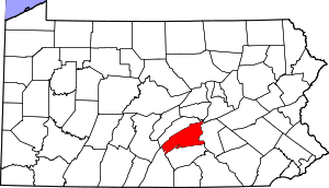 | |
| Townships | ||
| Unincorporated communities | ||