Charles County, Maryland
Charles County is a county in south central Maryland. As of the 2010 census, the population was 146,551.[1] The county seat is La Plata.[2] The county was named for Charles Calvert (1637–1715), third Baron Baltimore.
Charles County | |
|---|---|
 | |
 Flag  Seal | |
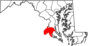 Location within the U.S. state of Maryland | |
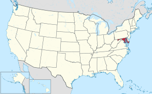 Maryland's location within the U.S. | |
| Coordinates: 38°29′N 77°01′W | |
| Country | |
| State | |
| Founded | April 13, 1658 |
| Named for | Charles Calvert |
| Seat | La Plata |
| Largest community | Waldorf |
| Area | |
| • Total | 643 sq mi (1,670 km2) |
| • Land | 458 sq mi (1,190 km2) |
| • Water | 185 sq mi (480 km2) 29%% |
| Population (2010) | |
| • Total | 146,551 |
| • Estimate (2019) | 163,257 |
| • Density | 230/sq mi (88/km2) |
| Time zone | UTC−5 (Eastern) |
| • Summer (DST) | UTC−4 (EDT) |
| Congressional district | 5th |
| Website | www |
Charles County is part of the Washington-Arlington-Alexandria, DC-VA-MD-WV Metropolitan Statistical Area and the Southern Maryland region.
History
Charles County was created in 1658 by an Order in Council. There was also an earlier Charles County from 1650 to 1653, sometimes referred to in historic documents as Old Charles County.[3][4][5]
In April 1865, John Wilkes Booth made his escape through Charles County after shooting President Abraham Lincoln. He was on his way to Virginia.
In 1926, a tornado ripped through the county leaving 17 dead (including 13 schoolchildren). On April 28, 2002, another tornado destroyed much of downtown La Plata.[6]
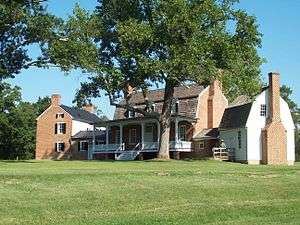
The county has a number of properties on the National Register of Historic Places.[7] Among them are Green Park and Pleasant Hill, home of the Green and Spalding Families.
On December 4, 2004, an arson took place in the development of Hunters Brooke, a few miles southeast of Indian Head. The Hunters Brooke Arson was the largest residential arson[8] in Maryland history.[9][10][11]
Law and government
Owing to the considerable voting power of its large number of freedmen following the Civil War,[12] and later its growth as a suburban area, Charles County was for a long time solidly Republican. The only Democrat to carry Charles County until 1956 was Franklin Roosevelt in 1932, although Alf Landon and Wendell Willkie defeated Roosevelt in the next two elections by a combined margin of just 50 votes. Since the turn of the millennium, Charles County has become reliably Democratic, although not as overwhelmingly so as other parts of Maryland's Washington, D.C. suburbs.[13] Charles County is only one of two counties in the nation to have voted for Al Gore in 2000 after voting for Bob Dole in 1996, along with Orange County, Florida.[14]
| Year | Republican | Democratic | Third parties |
|---|---|---|---|
| 2016 | 32.7% 25,614 | 63.0% 49,341 | 4.3% 3,348 |
| 2012 | 33.5% 25,178 | 64.8% 48,774 | 1.7% 1,270 |
| 2008 | 36.7% 25,732 | 62.2% 43,635 | 1.1% 760 |
| 2004 | 48.8% 28,442 | 50.4% 29,354 | 0.8% 445 |
| 2000 | 48.8% 21,768 | 49.1% 21,873 | 2.1% 951 |
| 1996 | 48.7% 17,432 | 44.4% 15,890 | 7.0% 2,501 |
| 1992 | 45.0% 17,293 | 37.7% 14,498 | 17.3% 6,663 |
| 1988 | 63.6% 20,828 | 36.1% 11,823 | 0.3% 113 |
| 1984 | 61.0% 16,132 | 38.8% 10,264 | 0.2% 64 |
| 1980 | 53.6% 11,807 | 40.4% 8,887 | 6.0% 1,326 |
| 1976 | 45.0% 7,792 | 55.0% 9,525 | |
| 1972 | 67.3% 9,665 | 31.4% 4,502 | 1.3% 186 |
| 1968 | 38.5% 4,645 | 35.2% 4,247 | 26.3% 3,173 |
| 1964 | 34.6% 3,455 | 65.5% 6,546 | |
| 1960 | 45.4% 4,560 | 54.6% 5,482 | |
| 1956 | 56.4% 5,088 | 43.6% 3,931 | |
| 1952 | 56.1% 4,334 | 43.2% 3,338 | 0.6% 49 |
| 1948 | 58.5% 2,703 | 40.6% 1,878 | 0.9% 40 |
| 1944 | 59.5% 2,755 | 40.5% 1,875 | |
| 1940 | 49.7% 2,716 | 49.3% 2,692 | 1.0% 56 |
| 1936 | 49.6% 2,623 | 49.2% 2,597 | 1.2% 64 |
| 1932 | 42.4% 1,851 | 56.6% 2,473 | 1.1% 47 |
| 1928 | 57.4% 2,522 | 42.4% 1,860 | 0.2% 9 |
| 1924 | 56.6% 2,215 | 38.1% 1,491 | 5.3% 208 |
| 1920 | 60.5% 2,585 | 38.5% 1,642 | 1.0% 43 |
| 1916 | 48.1% 1,374 | 47.7% 1,363 | 4.3% 122 |
| 1912 | 59.5% 1,573 | 34.7% 918 | 5.9% 155 |
| 1908 | 57.2% 1,643 | 40.7% 1,167 | 2.1% 61 |
| 1904 | 57.8% 1,659 | 41.1% 1,180 | 1.1% 31 |
| 1900 | 61.9% 2,268 | 37.4% 1,368 | 0.7% 26 |
Board of Commissioners
Charles County is governed by county commissioners, the traditional form of county government in Maryland. There are five commissioners. As of 2018, they are:
| Position | Name | Affiliation | District | |
|---|---|---|---|---|
| President | Reuben Collins | Democratic | At-Large | |
| Commissioner | Gilbert Bowling | Democratic | District 1 | |
| Commissioner | Amanda M. Stewart | Democratic | District 2 | |
| Commissioner | Thomasina Coates | Democratic | District 3 | |
| Commissioner | Bobby Rucci | Democratic | District 4 | |
Charles County is entirely within the 5th Congressional District, which also includes Calvert, St. Mary's, and parts of Anne Arundel and Prince George's counties. The current representative is Democratic House Majority Leader and (former House Minority Whip) Steny H. Hoyer.
Geography
According to the U.S. Census Bureau, the county has an area of 643 square miles (1,670 km2), of which 458 square miles (1,190 km2) is land and 185 square miles (480 km2) (29%) water.[17]
In its western wing, along the southernmost bend in Maryland Route 224, Charles County contains a place due north, east, south, and west of the same state—Virginia.[18]
Adjacent counties
- Prince George's County (north)
- Fairfax County, Virginia (northwest)
- Calvert County (east)
- Stafford County, Virginia (west)
- Prince William County, Virginia (west)
- St. Mary's County (southeast)
- Westmoreland County, Virginia (southeast)
- King George County, Virginia (south)
Major highways
National protected area
Demographics
| Historical population | |||
|---|---|---|---|
| Census | Pop. | %± | |
| 1790 | 20,613 | — | |
| 1800 | 19,172 | −7.0% | |
| 1810 | 20,245 | 5.6% | |
| 1820 | 16,500 | −18.5% | |
| 1830 | 17,769 | 7.7% | |
| 1840 | 16,023 | −9.8% | |
| 1850 | 16,162 | 0.9% | |
| 1860 | 16,517 | 2.2% | |
| 1870 | 15,738 | −4.7% | |
| 1880 | 18,548 | 17.9% | |
| 1890 | 15,191 | −18.1% | |
| 1900 | 17,662 | 16.3% | |
| 1910 | 16,386 | −7.2% | |
| 1920 | 17,705 | 8.0% | |
| 1930 | 16,166 | −8.7% | |
| 1940 | 17,612 | 8.9% | |
| 1950 | 23,415 | 32.9% | |
| 1960 | 32,572 | 39.1% | |
| 1970 | 47,678 | 46.4% | |
| 1980 | 72,751 | 52.6% | |
| 1990 | 101,154 | 39.0% | |
| 2000 | 120,546 | 19.2% | |
| 2010 | 146,551 | 21.6% | |
| Est. 2019 | 163,257 | [19] | 11.4% |
| U.S. Decennial Census[20] 1790-1960[21] 1900-1990[22] 1990-2000[23] 2010–2018[1] | |||
2000 census
As of the census[24] of 2000, there were 120,546 people, 41,668 households, and 32,292 families residing in the county. The population density was 262 people per square mile (101/km²). There were 43,903 housing units at an average density of 95 per square mile (37/km²). The racial makeup of the county was 68.51% White, 26.06% Black or African American, 0.75% Native American, 1.82% Asian, 0.06% Pacific Islander, 0.72% from other races, and 2.08% from two or more races. 2.26% of the population were Hispanic or Latino of any race. 11.6% were of German, 10.8% Irish, 10.2% English, 9.3% American and 5.3% Italian ancestry.
There were 41,668 households out of which 41.10% had children under the age of 18 living with them, 58.00% were married couples living together, 14.50% had a female householder with no husband present, and 22.50% were non-families. 17.20% of all households were made up of individuals and 5.20% had someone living alone who was 65 years of age or older. The average household size was 2.86 and the average family size was 3.21.
In the county, the population was spread out with 28.70% under the age of 18, 7.60% from 18 to 24, 33.20% from 25 to 44, 22.70% from 45 to 64, and 7.80% who were 65 years of age or older. The median age was 35 years. For every 100 females, there were 95.50 males. For every 100 females age 18 and over, there were 92.20 males.
The median income for a household in the county was $62,199, and the median income for a family was $67,602 (these figures had risen to $80,573 and $89,358 respectively as of a 2007 estimate). Males had a median income of $43,371 versus $34,231 for females. The per capita income for the county was $24,285. About 3.70% of families and 5.50% of the population were below the poverty line, including 6.70% of those under age 18 and 8.60% of those age 65 or over.
As of 2010 the county population's racial makeup was 48.38% Non-Hispanic whites, 40.96% blacks, 0.65% Native Americans, 2.98% Asian, 0.07% Pacific Islanders, 0.17% Non-Hispanics of some other race, 3.20% Non-Hispanics reporting more than one race and 4.27% Hispanic.
2010 census
As of the 2010 United States Census, there were 146,551 people, 51,214 households, and 38,614 families residing in the county.[25] The population density was 320.2 inhabitants per square mile (123.6/km2). There were 54,963 housing units at an average density of 120.1 per square mile (46.4/km2).[26] The racial makeup of the county was 50.3% white, 41.0% black or African American, 3.0% Asian, 0.7% American Indian, 0.1% Pacific islander, 1.3% from other races, and 3.7% from two or more races. Those of Hispanic or Latino origin made up 4.3% of the population.[25] In terms of ancestry, 12.6% were German, 10.8% were Irish, 8.7% were English, 6.3% were American, and 5.1% were Italian.[27]
Of the 51,214 households, 41.6% had children under the age of 18 living with them, 54.2% were married couples living together, 16.3% had a female householder with no husband present, 24.6% were non-families, and 19.8% of all households were made up of individuals. The average household size was 2.83 and the average family size was 3.24. The median age was 37.4 years.[25]
The median income for a household in the county was $88,825 and the median income for a family was $98,560. Males had a median income of $62,210 versus $52,477 for females. The per capita income for the county was $35,780. About 3.7% of families and 5.2% of the population were below the poverty line, including 6.8% of those under age 18 and 4.6% of those age 65 or over.[28]
Economy
Top employers
According to Charles County's 2013 Comprehensive Annual Financial Report,[29] its top employers are:
| # | Employer | # of Employees | Percentage of Total County Employment |
|---|---|---|---|
| 1 | Charles County Board of Education | 3,430 | 4.35% |
| 2 | Indian Head Naval Surface Warfare Center | 3,404 | 4.49% |
| 3 | Charles County Government | 1,638 | 2.16% |
| 4 | Civista Medical Center | 850 | 1.12% |
| 5 | College of Southern Maryland | 819 | 1.08% |
| 6 | Wal-Mart/Sam's Club | 592 | 0.78% |
| 7 | The Facchina Group of Companies | 550 | 0.73% |
| 8 | Safeway | 475 | 0.63% |
| 9 | Target | 400 | 0.53% |
| 10 | McDonald's | 396 | 0.52% |
| 11 | Southern Maryland Electric Cooperative | 386 | 0.51% |
| 12 | Genesis Health Care | 312 | 0.41% |
| 13 | Bloomin' Brands (formerly OSI Restaurant Partners) | 300 | 0.40% |
| 14 | Charles County Nursing Home | 255 | 0.34% |
| 15 | Darden Restaurants | 253 | 0.33% |
| 16 | Macy's | 250 | 0.33% |
Communities
Towns
- Indian Head
- La Plata (county seat)
- Port Tobacco Village
Census-designated places
The Census Bureau recognizes the following census-designated places in the county:
Unincorporated communities
- Bel Alton
- Benedict
- Dentsville
- Faulkner
- Glymont
- Grayton[30]
- Ironsides
- Issue
- Malcolm
- Marbury
- Morgantown
- Mount Victoria
- Nanjemoy
- Newburg
- Pisgah
- Popes Creek
- Port Tobacco
- Pomonkey
- Ripley
- Rison
- Swan Point
- Welcome
- White Plains
Notable people
- Chuck Brown (1936–2012), the godfather of go-go, lived in Waldorf
- Gustavus Richard Brown, physician to George Washington
- George Cary (1811–1850), born near Allens Fresh in Charles County, United States Congressman from Georgia[31]
- Barnes Compton, US Congressman
- James Craik, Physician General during the American Revolution, physician to George Washington
- Danny Gatton (1945–1994), legendary guitarist, lived in Newburg
- John Hanson, American Revolutionary War statesman
- Josiah Henson (1789–1883), former slave and author
- Matthew Henson, co-discoverer of the North Pole; born near Nanjemoy
- Daniel of St. Thomas Jenifer, American Revolutionary War statesman
- Larry Johnson, former NFL running back; from Pomfret
- Jane Herbert Wilkinson Long (1798–1880), considered to be the "Mother of Texas"
- Shawn Lemon, professional football player; grew up in Waldorf
- Joel and Benji Madden from the band Good Charlotte; grew up in Waldorf
- Christina Milian, musician, lived in Waldorf
- Samuel Alexander Mudd (1833–1883), born in Charles County, the doctor implicated and imprisoned for aiding John Wilkes Booth in the assassination of President Abraham Lincoln
- James Neale (1615–1684), born London, England, immigrated 1634, founded Wollaston Manor plantation and Cobb Island
- Captain Raphael Semmes of the Confederate ship Alabama, born near Nanjemoy
- General William Smallwood, American Revolutionary War statesman
- Randy Starks, former NFL defensive tackle; from Waldorf
- Robert Stethem, noted terror hijacking victim, grew up in Pinefield, Waldorf
- Benjamin Stoddert (1751–1813), first United States Secretary of the Navy
- Thomas Stone, American Revolutionary War statesman
- Angela Renée White "Blac Chyna", Television Personality; Attended Henry E. Lackey[32]
Sports
| Club | League | Venue | Established | Championships |
|---|---|---|---|---|
| Southern Maryland Blue Crabs | ALPB, Baseball | Regency Furniture Stadium | 2008 | 0 |
References
- "State & County QuickFacts". United States Census Bureau. Archived from the original on February 20, 2016. Retrieved August 24, 2013.
- "Find a County". National Association of Counties. Archived from the original on 2011-05-31. Retrieved June 7, 2011.
- "The Counties of Maryland". 630. The Archives of Maryland Online: 122–124. Retrieved November 16, 2007. Cite journal requires
|journal=(help) - Maryland Geological Survey (1911). "Prince George's County". The Johns Hopkins Press: 21–22. Retrieved November 16, 2007. Cite journal requires
|journal=(help) - Maryland Geological Survey (1906). "Maryland Geological Survey: General Reports". The Johns Hopkins Press: 474–477. Retrieved April 5, 2008. Cite journal requires
|journal=(help) - ""An account of deadly 1926 La Plata tornado"". Baltimore Sun. November 19, 2009.
- "National Register Information System". National Register of Historic Places. National Park Service. April 15, 2008.
- United States Attorney for the District of Maryland (March 1, 2006). "Violent Crime Program 2005 Annual Report" (PDF). United States Department of Justice. Archived from the original (PDF) on August 29, 2010. Retrieved August 2, 2010.
- Courson, Paul; Joanthan Wild (December 21, 2004). "Two more arrested in Maryland fires". Washington, Dc: CNN. p. 1. Retrieved August 2, 2010.
- Witte, Brian (January 3, 2005). "Maryland Hunts for Motives Behind State's Largest Residential Arson". Insurance Journal. Retrieved August 2, 2010.
- Hancock, David (December 18, 2004). "3 More Charged In Maryland Arson". LA PLATA, Md: CBS NEWS. p. 1. Retrieved August 2, 2010.
- Levine, Mark V.; ‘Standing Political Decisions and Critical Realignment: The Pattern of Maryland Politics, 1872-1948’; The Journal of Politics, volume 38, no. 2 (May, 1976), pp. 292-325
- "JOSH KURTZ: FORGET PRINCE GEORGE'S – CHECK OUT KING CHARLES FOR POLITICAL INTRIGUE". Center Maryland. 2 June 2014. Retrieved 20 September 2016.
- "The 2016 Streak Breakers". Sabato Crystal Ball. Retrieved 2017-09-15.
- Leip, David. "Dave Leip's Atlas of U.S. Presidential Elections". uselectionatlas.org. Retrieved 2018-06-11.
- "Washington-Arlington-Alexandria, DC-VA-MD-WV". U.S. Census Bureau. U.S. Department of Commerce. Retrieved 12 April 2017.
- "2010 Census Gazetteer Files". United States Census Bureau. August 22, 2012. Archived from the original on September 13, 2014. Retrieved September 12, 2014.
- This oddity of political geography happens in other places in Maryland.
- "Population and Housing Unit Estimates". Retrieved April 26, 2019.
- "U.S. Decennial Census". United States Census Bureau. Retrieved September 12, 2014.
- "Historical Census Browser". University of Virginia Library. Retrieved September 12, 2014.
- "Population of Counties by Decennial Census: 1900 to 1990". United States Census Bureau. Retrieved September 12, 2014.
- "Census 2000 PHC-T-4. Ranking Tables for Counties: 1990 and 2000" (PDF). United States Census Bureau. Retrieved September 12, 2014.
- "U.S. Census website". United States Census Bureau. Retrieved January 31, 2008.
- "DP-1 Profile of General Population and Housing Characteristics: 2010 Demographic Profile Data". United States Census Bureau. Archived from the original on 2020-02-13. Retrieved 2016-01-22.
- "Population, Housing Units, Area, and Density: 2010 - County". United States Census Bureau. Archived from the original on 2020-02-13. Retrieved 2016-01-22.
- "DP02 SELECTED SOCIAL CHARACTERISTICS IN THE UNITED STATES – 2006-2010 American Community Survey 5-Year Estimates". United States Census Bureau. Archived from the original on 2020-02-13. Retrieved 2016-01-22.
- "DP03 SELECTED ECONOMIC CHARACTERISTICS – 2006-2010 American Community Survey 5-Year Estimates". United States Census Bureau. Archived from the original on 2020-02-13. Retrieved 2016-01-22.
- "Charles County, Maryland Comprehensive Annual Financial Report For the Fiscal Year Ended June 30, 2013" (PDF). Charles County Government. Archived from the original (PDF) on May 12, 2014. Retrieved 22 June 2014.
- "Who Was Who in America, Historical Volume, 1607–1896". Chicago: Marquis Who's Who. 1963. Cite journal requires
|journal=(help) - "Blac Chyna - Before She Was Famous - Michael McCrudden". Michael McCrudden. 2016-05-11. Retrieved 2017-02-13.
External links
| Wikimedia Commons has media related to Charles County, Maryland. |
- Official website
- Charles County at the Wayback Machine (archived June 1, 2012)
- Hamilton Family papers, at the University of Maryland libraries. A prominent Charles County family with records from 1803-1923.
Places adjacent to Charles County, Maryland | |
|---|---|
Municipalities and communities of Charles County, Maryland, United States | ||
|---|---|---|
| Towns | | |
| CDPs | ||
| Other communities | ||
.svg.png)
| Principal cities (and city-like entities) |
|   | |||||||
|---|---|---|---|---|---|---|---|---|---|
| Counties (and county equivalents) |
| ||||||||
The District of Columbia itself, and Virginia's incorporated cities, are county equivalents. Virginia's incorporated cities are listed under their surrounding county. The incorporated cities bordering more than one county (Alexandria, Falls Church and Fredericksburg) are listed under the county they were part of before incorporation as a city. Some unincorporated areas and census-designated places like Silver Spring and Bethesda in Maryland, Reston in Virginia, as well as the County of Arlington in Virginia are also treated as city-like entities (or principal cities) even though they have not been legally incorporated as such. | |||||||||
| Authority control |
|
|---|