Wayne County, West Virginia
Wayne County is the westernmost county in the U.S. state of West Virginia. As of the 2010 census, the population was 42,481.[1] Its county seat is Wayne.[2] The county was founded in 1842 and named for General "Mad" Anthony Wayne.[3]
Wayne County | |
|---|---|
 | |
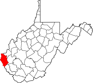 Location within the U.S. state of West Virginia | |
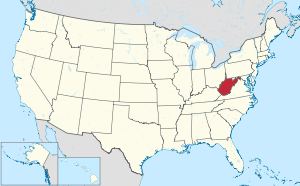 West Virginia's location within the U.S. | |
| Coordinates: 38°09′N 82°26′W | |
| Country | |
| State | |
| Founded | January 18, 1842 |
| Named for | Anthony Wayne |
| Seat | Wayne |
| Largest city | Kenova |
| Area | |
| • Total | 512 sq mi (1,330 km2) |
| • Land | 506 sq mi (1,310 km2) |
| • Water | 6.1 sq mi (16 km2) 1.2%% |
| Population (2010) | |
| • Total | 42,481 |
| • Estimate (2018) | 39,944 |
| • Density | 83/sq mi (32/km2) |
| Time zone | UTC−5 (Eastern) |
| • Summer (DST) | UTC−4 (EDT) |
| Congressional district | 3rd |
| Website | www |
Wayne County is part of the Huntington-Ashland, WV-KY-OH Metropolitan Statistical Area.
History
Wayne County, West Virginia was originally Wayne County, Virginia, which was created from part of Cabell County in 1842. The county was named for General "Mad" Anthony Wayne.
Settlement
There was no white settlement in the area that became Wayne County until after 1794, due to the constant threat of Indian attack. The area was made safe for white settlement in 1794 through the defeat of the Shawnee at the Battle of Fallen Timbers by General "Mad" Anthony Wayne.
When the first permanent European settlers came to Wayne County around the year 1800, the area was part of Kanawha County. Most of the original pioneer settlers were self-sufficient farmers. They raised their own food, sheep for wool clothing, and made their buildings, furnishings and tools out of the surrounding forest. A few trading posts provided the manufactured goods the pioneers could not make for themselves. Later, grist mills at Wayne, Dickson, south of East Lynn and at Lavalette ground their corn into meal and their wheat into flour.
On June 20, 1863, at the height of the Civil War, Wayne was one of fifty Virginia counties that were admitted to the Union as the state of West Virginia. Later that year, the counties were divided into civil townships, with the intention of encouraging local government. This proved impractical in the heavily rural state, and in 1872 the townships were converted into magisterial districts.[4] Wayne County was divided into five districts: Butler, Ceredo, Grant, Lincoln, and Union. A sixth district, Stonewall, was formed from part of Grant District in 1878. In the 1920s, Westmoreland was created as the county's seventh magisterial district. Grant District was discontinued between 1960 and 1970, followed by Lincoln in the 1980s.[5]
Geography
According to the U.S. Census Bureau, the county has a total area of 512 square miles (1,330 km2), of which 506 square miles (1,310 km2) is land and 6.1 square miles (16 km2) (1.2%) is water.[6]
Rivers and lakes
- Ohio River
- Big Sandy River
- Twelvepole Creek
- Beech Fork Lake
- East Lynn Lake
- Tug Fork
Major highways
.svg.png)


Adjacent counties
- Lawrence County, Ohio (north)
- Cabell County (northeast)
- Lincoln County (east)
- Mingo County (southeast)
- Martin County, Kentucky (south)
- Lawrence County, Kentucky (west)
- Boyd County, Kentucky (northwest)
Wayne County is one of three counties (along with Apache County, Arizona and Cook County, Illinois) to border two counties of the same name, neither of which are in the same state as the county itself (Lawrence County, Ohio and Lawrence County, Kentucky).
Demographics
| Historical population | |||
|---|---|---|---|
| Census | Pop. | %± | |
| 1850 | 4,760 | — | |
| 1860 | 6,747 | 41.7% | |
| 1870 | 7,852 | 16.4% | |
| 1880 | 14,739 | 87.7% | |
| 1890 | 18,652 | 26.5% | |
| 1900 | 23,619 | 26.6% | |
| 1910 | 24,081 | 2.0% | |
| 1920 | 26,012 | 8.0% | |
| 1930 | 31,206 | 20.0% | |
| 1940 | 35,566 | 14.0% | |
| 1950 | 38,696 | 8.8% | |
| 1960 | 38,977 | 0.7% | |
| 1970 | 37,581 | −3.6% | |
| 1980 | 46,021 | 22.5% | |
| 1990 | 41,636 | −9.5% | |
| 2000 | 42,903 | 3.0% | |
| 2010 | 42,481 | −1.0% | |
| Est. 2018 | 39,944 | [7] | −6.0% |
| U.S. Decennial Census[8] 1790–1960[9] 1900–1990[10] 1990–2000[11] 2010–2018[1] | |||
2000 census
As of the census[12] of 2000, there were 42,903 people, 17,239 households, and 12,653 families living in the county. The population density was 85 people per square mile (33/km²). There were 19,107 housing units at an average density of 38 per square mile (15/km²). The racial makeup of the county was 98.79% White, 0.13% Black or African American, 0.23% Native Americans, 0.20% Asian, 0.02% Pacific Islander, 0.08% from other races, and 0.56% from two or more races. 0.47% of the population were Hispanic or Latino of any race.
There were 17,239 households out of which 31.20% had children under the age of 18 living with them, 59.20% were married couples living together, 10.80% had a female householder with no husband present, and 26.60% were non-families. 24.10% of all households were made up of individuals and 11.10% had someone living alone who was 65 years of age or older. The average household size was 2.48 and the average family size was 2.92.
In the county, the population was spread out with 23.40% under the age of 18, 8.70% from 18 to 24, 27.70% from 25 to 44, 25.30% from 45 to 64, and 14.90% who were 65 years of age or older. The median age was 38 years. For every 100 females there were 95.80 males. For every 100 females age 18 and over, there were 91.80 males.
The median income for a household in the county was $27,352, and the median income for a family was $32,458. Males had a median income of $31,554 versus $20,720 for females. The per capita income for the county was $14,906. About 16.20% of families and 19.60% of the population were below the poverty line, including 25.50% of those under age 18 and 15.20% of those age 65 or over.
2010 census
As of the 2010 United States Census, there were 42,481 people, 17,347 households, and 12,128 families living in the county.[13] The population density was 84.0 inhabitants per square mile (32.4/km2). There were 19,227 housing units at an average density of 38.0 per square mile (14.7/km2).[14] The racial makeup of the county was 98.6% white, 0.3% American Indian, 0.2% black or African American, 0.2% Asian, 0.1% from other races, and 0.8% from two or more races. Those of Hispanic or Latino origin made up 0.5% of the population.[13] In terms of ancestry, 18.1% were Irish, 16.9% were English, 13.0% were American, and 11.8% were German.[15]
Of the 17,347 households, 30.9% had children under the age of 18 living with them, 53.2% were married couples living together, 11.7% had a female householder with no husband present, 30.1% were non-families, and 26.4% of all households were made up of individuals. The average household size was 2.43 and the average family size was 2.92. The median age was 41.3 years.[13]
The median income for a household in the county was $35,079 and the median income for a family was $44,886. Males had a median income of $40,233 versus $25,765 for females. The per capita income for the county was $18,410. About 16.4% of families and 20.2% of the population were below the poverty line, including 23.2% of those under age 18 and 15.0% of those age 65 or over.[16]
Ancestry/Ethnicity
As of 2017 the largest self-identified ancestry groups in Wayne County were:
| Largest ancestries (2015) | Percent |
|---|---|
| English | 23.7% |
| Irish | 13.7% |
| "American" | 12.2% |
| German | 9.5% |
| Italian | 2.2% |
| Scottish | 2.1% |
| Scots-Irish | 2.0% |
| French (except Basque) | 1.0% |
| Polish | 0.7% |
Politics
Prior to 2000, Wayne County was strongly Democratic in presidential elections, with only four Republican candidates winning the county from 1912 to 1996, all as a part of a national landslide win for the party. Since 2000, the county has swung to becoming strongly Republican similar to the rest of West Virginia, so strongly that Donald Trump won the county in 2016 by a margin of over 50 percent.
| Year | Republican | Democratic | Third parties |
|---|---|---|---|
| 2016 | 72.7% 11,152 | 21.9% 3,357 | 5.5% 838 |
| 2012 | 62.0% 8,688 | 35.2% 4,931 | 2.8% 390 |
| 2008 | 58.0% 8,947 | 39.8% 6,137 | 2.2% 346 |
| 2004 | 54.1% 10,070 | 45.2% 8,411 | 0.7% 128 |
| 2000 | 49.2% 7,993 | 48.9% 7,940 | 1.9% 308 |
| 1996 | 35.5% 5,492 | 53.6% 8,300 | 10.9% 1,684 |
| 1992 | 35.1% 5,729 | 51.4% 8,392 | 13.6% 2,223 |
| 1988 | 45.2% 7,123 | 54.7% 8,621 | 0.2% 31 |
| 1984 | 51.1% 8,811 | 48.6% 8,378 | 0.3% 47 |
| 1980 | 45.1% 7,541 | 52.0% 8,687 | 2.9% 491 |
| 1976 | 37.6% 6,009 | 62.4% 9,958 | |
| 1972 | 61.0% 9,775 | 39.0% 6,251 | |
| 1968 | 36.8% 6,004 | 50.4% 8,227 | 12.8% 2,088 |
| 1964 | 31.6% 5,340 | 68.4% 11,578 | |
| 1960 | 47.1% 8,128 | 52.9% 9,140 | |
| 1956 | 52.4% 8,429 | 47.6% 7,655 | |
| 1952 | 44.9% 7,059 | 55.2% 8,679 | |
| 1948 | 36.5% 4,394 | 63.3% 7,618 | 0.2% 19 |
| 1944 | 40.5% 4,516 | 59.5% 6,627 | |
| 1940 | 37.2% 5,701 | 62.8% 9,626 | |
| 1936 | 38.4% 5,603 | 61.4% 8,954 | 0.2% 31 |
| 1932 | 34.9% 4,682 | 64.4% 8,648 | 0.7% 90 |
| 1928 | 51.9% 5,630 | 47.7% 5,177 | 0.4% 42 |
| 1924 | 39.0% 3,999 | 57.3% 5,870 | 3.7% 378 |
| 1920 | 45.5% 3,754 | 54.5% 4,490 | |
| 1916 | 42.2% 2,215 | 57.0% 2,989 | 0.8% 43 |
| 1912 | 29.4% 1,465 | 52.9% 2,634 | 17.7% 882 |
Transportation
Rail
- Norfolk Southern Railway's former N&W Kenova District
- CSX Transportation's former C&O Kanawha Sub
- Kanawha River Terminal Railroad
Air
The public Tri-State Airport, the major airport serving the Huntington–Ashland area, is located in Wayne County south of Interstate 64. The airport is accessible from Interstate 64 via Exit 1. Commercial air service is provided by Allegiant Air and American Airlines.
Communities
Cities
- Huntington (mostly in Cabell County)
- Kenova
Magisterial districts
Current
- Butler
- Ceredo
- Stonewall
- Union
- Westmoreland
Historic
- Grant
- Lincoln
Unincorporated communities
- Ardel
- Armilda
- Bethesda
- Booton
- Bowen
- Brabant
- Buffalo Creek
- Centerville
- Coleman
- Cove Gap
- Crockett
- Cyrus
- Dickson
- Doane
- Dunlow
- East Lynn
- Echo
- Effie
- Elmwood
- Ferguson
- Fleming
- Genoa
- Gilkerson
- Girard
- Glenhayes
- Grandview Gardens
- Hidden Valley
- Hubbardstown
- Mineral Springs
- Missouri Branch
- Neal
- Nestlow
- Oakview Heights
- Quaker
- Radnor
- Saltpetre
- Shoals
- Sidney
- Stepptown
- Stiltner (defunct)
- Stonecoal
- Sweet Run
- Tripp
- Webb
- Wilsondale
- Winslow
In popular culture
The following books take place in Wayne County:
- Last Train to Dunlow by Kay and Jack Dickinson. OCLC 66901525.
- On the Trail of the Powhatan Arrow by Kay and Jack Dickinson. ISBN 978-0-9774116-1-0.
- Discovering Lavalette by Gina Simmons. ISBN 978-1-4389-8707-1.
- Pioneers, Rebels and Wolves by Robert Thompson.
- Climbing Trout's Hill by Robert Thompson.
- East Lynn Booming by Robert Thompson. OCLC 363205071.
- Images Of East Lynn by Robert Thompson.
- Fear No Man by Robert Thompson.
- Aging Wonders by Robert Thompson.
- Few Among The Mountains by Robert Thompson.
- Crum by Lee Maynard
- "Protectors of the Ohio Valley by Matthew A. Perry ISBN 153292710X
See also
References
- "State & County QuickFacts". United States Census Bureau. Archived from the original on February 11, 2016. Retrieved January 16, 2014.
- "Find a County". National Association of Counties. Retrieved 2011-06-07.
- "Archived copy". Archived from the original on September 23, 2001. Retrieved February 4, 2013.CS1 maint: archived copy as title (link)
- Otis K. Rice & Stephen W. Brown, West Virginia: A History, 2nd ed., University Press of Kentucky, Lexington (1993), p. 240.
- United States Census Bureau, U.S. Decennial Census, Tables of Minor Civil Divisions in West Virginia, 1870–2010.
- "2010 Census Gazetteer Files". United States Census Bureau. August 22, 2012. Retrieved July 31, 2015.
- "Population and Housing Unit Estimates". Retrieved May 21, 2019.
- "U.S. Decennial Census". United States Census Bureau. Retrieved January 16, 2014.
- "Historical Census Browser". University of Virginia Library. Retrieved January 16, 2014.
- "Population of Counties by Decennial Census: 1900 to 1990". United States Census Bureau. Retrieved January 16, 2014.
- "Census 2000 PHC-T-4. Ranking Tables for Counties: 1990 and 2000" (PDF). United States Census Bureau. Retrieved January 16, 2014.
- "U.S. Census website". United States Census Bureau. Retrieved May 14, 2011.
- "DP-1 Profile of General Population and Housing Characteristics: 2010 Demographic Profile Data". United States Census Bureau. Archived from the original on February 13, 2020. Retrieved April 3, 2016.
- "Population, Housing Units, Area, and Density: 2010 - County". United States Census Bureau. Archived from the original on February 13, 2020. Retrieved April 3, 2016.
- "DP02 SELECTED SOCIAL CHARACTERISTICS IN THE UNITED STATES – 2006-2010 American Community Survey 5-Year Estimates". United States Census Bureau. Archived from the original on February 13, 2020. Retrieved April 3, 2016.
- "DP03 SELECTED ECONOMIC CHARACTERISTICS – 2006-2010 American Community Survey 5-Year Estimates". United States Census Bureau. Archived from the original on February 13, 2020. Retrieved April 3, 2016.
- Leip, David. "Dave Leip's Atlas of U.S. Presidential Elections". uselectionatlas.org. Retrieved 2018-03-28.
Places adjacent to Wayne County, West Virginia | ||||||||||
|---|---|---|---|---|---|---|---|---|---|---|
| ||||||||||
Municipalities and communities of Wayne County, West Virginia, United States | ||
|---|---|---|
| Cities | Wayne County map | |
| Towns | ||
| CDPs | ||
| Unincorporated communities |
| |
| Footnotes | ‡This populated place also has portions in an adjacent county or counties | |
Huntington-Ashland-Ironton metropolitan area | ||
|---|---|---|
| Principal cities |  | |
| Municipalities with population over 5,000 | ||
| Municipalities with population 1,000–5,000 | ||
| Municipalities with population under 1,000 | ||
| West Virginia counties | ||
| Kentucky counties | ||
| Ohio counties | ||
| Authority control |
|
|---|