Milwaukee metropolitan area
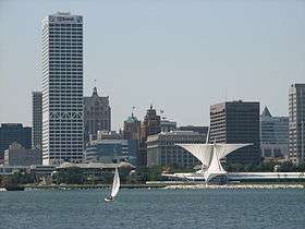
The Milwaukee metropolitan area (also known as Metro Milwaukee or Greater Milwaukee) is a major metropolitan area located in Southeastern Wisconsin, consisting of the city of Milwaukee and the surrounding area. There are several definitions of the area, including the Milwaukee–Waukesha–West Allis metropolitan area and the Milwaukee–Racine–Waukesha combined statistical area. It is the largest metropolitan area in Wisconsin, and the 39th largest metropolitan area in the United States.
Definitions
Metropolitan area
| Historical population | |||
|---|---|---|---|
| Census | Pop. | %± | |
| 1840 | 5,948 | — | |
| 1850 | 69,820 | 1,073.8% | |
| 1860 | 128,653 | 84.3% | |
| 1870 | 157,687 | 22.6% | |
| 1880 | 206,397 | 30.9% | |
| 1890 | 318,065 | 54.1% | |
| 1900 | 405,198 | 27.4% | |
| 1910 | 511,194 | 26.2% | |
| 1920 | 624,109 | 22.1% | |
| 1930 | 821,566 | 31.6% | |
| 1940 | 876,954 | 6.7% | |
| 1950 | 1,014,211 | 15.7% | |
| 1960 | 1,278,850 | 26.1% | |
| 1970 | 1,403,688 | 9.8% | |
| 1980 | 1,397,143 | −0.5% | |
| 1990 | 1,432,149 | 2.5% | |
| 2000 | 1,500,741 | 4.8% | |
| 2010 | 1,555,908 | 3.7% | |
| Est. 2019 | 1,575,179 | [1] | 1.2% |
| U.S. Decennial Census[2] 1790–1960[3] 1900–1990[4] 1990–2000[5] 2010–2014 | |||
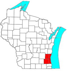
The U.S. Census Bureau defines the Milwaukee Metropolitan area as containing four counties in southeastern Wisconsin: Milwaukee, Waukesha, Washington and Ozaukee. The Metropolitan population of Milwaukee was 1,572,245 in a 2014 estimate.[6]
The city of Milwaukee is the hub of the metropolitan area. The eastern parts of Racine County, eastern parts of Waukesha County, southern part of Ozaukee County, southeastern part of Washington County, and remainder of Milwaukee County are the most urbanized parts of the outlying counties.
The character of the area varies widely. Mequon, Brookfield, and the North Shore (Fox Point, Whitefish Bay, River Hills, Shorewood, Glendale, and Bayside) are more white-collar, while West Milwaukee, West Allis, and St. Francis are more blue-collar.
Metro Milwaukee draws commuters from outlying areas such as Madison, Chicago and the Fox Cities. It is part of the Great Lakes Megalopolis containing an estimated 54 million people.
Combined statistical area
The Milwaukee–Racine–Waukesha Combined Statistical Area is made up of the Milwaukee–Waukesha–West Allis Metropolitan Statistical Area (Milwaukee, Waukesha, Washington and Ozaukee counties), the Racine Metropolitan Statistical Area (Racine County), the Beaver Dam Micropolitan Statistica Area (Dodge County), the Watertown-Fort Atkinson Micropolitan Area (Jefferson County), and the Whitewater-Elkorn Micropolitan Area (Walworth County) according to the U.S. Census.[7] Updated definitions released in February 2013 added Dodge, Jefferson and Walworth Counties to the Milwaukee CSA. Kenosha, despite being just 32 miles from Milwaukee and 50 miles from Chicago, is included as part of the Chicago CSA, as Kenosha has more residents who commute to the Chicago area. In a 2014 estimate the Milwaukee–Racine–Waukesha Combined Statistical Area population was 2,043,904, the largest in Wisconsin and the 30th largest in the United States.[8]
Counties
There are eight counties in the U.S. Census Bureau's Milwaukee–Racine–Waukesha Combined statistical area.
Cities
Primary
- Milwaukee
Metro area cities and villages with more than 10,000 inhabitants
- Beaver Dam
- Brookfield
- Brown Deer
- Burlington
- Caledonia
- Cedarburg
- Cudahy
- Delavan
- Elkhorn
- Fort Atkinson
- Franklin
- Germantown
- Glendale
- Grafton
- Greendale
- Greenfield
- Hartford
- Menomonee Falls
- Mequon
- Mount Pleasant
- Muskego
- New Berlin
- Oak Creek
- Oconomowoc
- Pewaukee
- Port Washington
- Richfield
- Shorewood
- South Milwaukee
- Sussex
- Watertown
- Wauwatosa
- West Allis
- West Bend
- Whitefish Bay
- Whitewater
Metro area cities, towns and villages with fewer than 10,000 inhabitants
- Addison
- Barton
- Bayside
- Belgium
- Big Bend
- Bohners Lake
- Browns Lake
- Brownsville
- Butler
- Chenequa
- Clyman
- Darien
- Delafield (city)
- Delafield (town)
- Dousman
- Dover
- Eagle
- Eagle Lake
- East Troy
- Elkhorn
- Elm Grove
- Elmwood Park
- Erin
- Farmington
- Fox Lake
- Fox Point
- Franksville
- Fredonia
- Genesee
- Germantown (town)
- Hales Corners
- Hartland
- Herman
- Horicon
- Hustisford
- Ixonia
- Iron Ridge
- Jackson
- Jefferson
- Johnson Creek
- Juneau
- Kekoskee
- Kewaskum
- Lac La Belle
- Lake Geneva
- Lake Mills
- Lannon
- Leroy
- Lisbon
- Lomira
- Lowell
- Mayville
- Merton
- Mukwonago
- Nashotah
- Neosho
- Newburg
- North Bay
- North Prairie
- Norway
- Oconomowoc Lake
- Okauchee Lake
- Ottawa
- Palmyra
- Pewaukee(village)
- Polk
- Randolph
- Raymond
- Reeseville
- River Hills
- Rochester
- Rubicon
- Saukville
- Slinger
- St. Francis
- Sturtevant
- Sullivan
- Summit
- Theresa
- Thiensville
- Trenton
- Union Grove
- Vernon
- Wales
- Walworth
- Waterford
- Waterloo
- Waupun
- Wayne
- West Milwaukee
- Williams Bay
- Wind Lake
- Wind Point
- Yorkville
Unincorporated Communities and Census Designated Places
Debate over metropolitan government
Although each county and its various municipalities are self-governing, there is some cooperation in the metropolitan area. The Milwaukee Metropolitan Sewerage District (MMSD) is a state-chartered government agency which serves 28 municipalities in the five counties.
At the same time, some in the area see the need for more consolidation in government services. The Kettl Commission and former Wisconsin Governor Scott McCallum have supported initiatives to do this. However, full consolidation has been criticized as a means of diluting minority voting power.
References
- "County Totals Dataset: Population, Population Change and Estimated Components of Population Change: April 1, 2010 to July 1, 2015". Archived from the original on July 8, 2016. Retrieved July 2, 2016.
- "U.S. Decennial Census". United States Census Bureau. Retrieved August 9, 2015.
- "Historical Census Browser". University of Virginia Library. Retrieved August 9, 2015.
- Forstall, Richard L., ed. (March 27, 1995). "Population of Counties by Decennial Census: 1900 to 1990". United States Census Bureau. Retrieved August 9, 2015.
- "Census 2000 PHC-T-4. Ranking Tables for Counties: 1990 and 2000" (PDF). United States Census Bureau. April 2, 2001. Retrieved August 9, 2015.
- "Archived copy". Archived from the original on 2015-05-10. Retrieved 2015-06-03.CS1 maint: archived copy as title (link)
- "Archived copy" (PDF). Archived from the original (PDF) on 2017-01-18. Retrieved 2015-02-13.CS1 maint: archived copy as title (link)
- "Archived copy". Archived from the original on 2015-05-10. Retrieved 2015-06-03.CS1 maint: archived copy as title (link)
External links
- 2003 article on consolidation of area governments
- https://web.archive.org/web/20170118134056/https://www.whitehouse.gov/sites/default/files/omb/bulletins/2013/b-13-01.pdf
|  | |
| ||

| Central city | 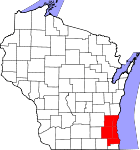 | |
|---|---|---|
| Largest municipalities (over 25,000 in 2010) | ||
| Municipalities (over 10,000 in 2010) | ||
| Smaller municipalities (under 10,000 in 2010) |
| |
| Counties | ||
| Other topics | ||
Notes: Vvillage Ttown Ccity | ||
Great Lakes megaregion as defined by RPA | ||
|---|---|---|
Note: A few Great Lakes regions cities in Canada are left out. Metropolitan areas have +150,000 according to source at the time estimated. | ||
| Great Lakes region cities | 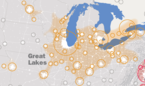 | |
| Surrounding cities |
| |
| Cities of states south of region | ||
| Other metro-regions | ||