Wichita, KS Metropolitan Statistical Area
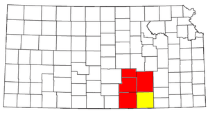
The Wichita, KS Metropolitan Statistical Area, as defined by the United States Office of Management and Budget, is an area consisting of four counties in south central Kansas, anchored by the city of Wichita. As of the 2013 American Community Survey, the MSA had a population of 637,989. It is the largest metropolitan area in the state of Kansas.
Communities
Populations are from the 2010 census.
| Historical population | |||
|---|---|---|---|
| Census | Pop. | %± | |
| 1900 | 44,037 | — | |
| 1910 | 73,095 | 66.0% | |
| 1920 | 92,234 | 26.2% | |
| 1930 | 136,330 | 47.8% | |
| 1940 | 143,311 | 5.1% | |
| 1950 | 222,290 | 55.1% | |
| 1960 | 432,807 | 94.7% | |
| 1970 | 440,141 | 1.7% | |
| 1980 | 466,772 | 6.1% | |
| 1990 | 511,111 | 9.5% | |
| 2000 | 571,168 | 11.8% | |
| 2010 | 623,061 | 9.1% | |
| Est. 2018 | 644,888 | 3.5% | |
| U.S. Decennial Census[1] | |||
Places with more than 300,000 inhabitants
- Wichita (Principal city) Pop: 389,902
Places with 10,000 to 25,000 inhabitants
Places with 5,000 to 10,000 inhabitants
- Augusta Pop: 9,274
- Wellington Pop: 8,172
- Park City Pop: 7,297
- Valley Center Pop: 6,822
- Bel Aire Pop: 6,769
- Mulvane Pop: 6,111
Places with 1,000 to 5,000 inhabitants
- Goddard Pop: 4,344
- Rose Hill Pop: 3,931
- Hesston Pop: 3,709
- Maize Pop: 3,420
- Oaklawn-Sunview (census-designated place) Pop: 3,276
- Clearwater Pop: 2,481
- Cheney Pop: 2,094
- Halstead Pop: 2,085
- Kechi Pop: 1,909
- McConnell Air Force Base (census-designated place) Pop: 1,777
- North Newton Pop: 1,759
- Douglass Pop: 1,700
- Sedgwick Pop: 1,695
- Belle Plaine Pop: 1,681
- Towanda Pop: 1,450
- Colwich Pop: 1,327
- Conway Springs Pop: 1,272
- Caldwell Pop: 1,068
- Oxford Pop: 1,049
Places with fewer than 1,000 inhabitants
- Andale Pop: 928
- Burrton Pop: 901
- Benton Pop: 880
- Garden Plain Pop: 840
- Mount Hope Pop: 813
- Eastborough Pop: 773
- Whitewater Pop: 718
- Leon Pop: 704
- Bentley Pop: 530
- Argonia Pop: 501
- Potwin Pop: 449
- South Haven Pop: 363
- Walton Pop: 235
- Elbing Pop: 229
- Geuda Springs (partial) Pop: 185
- Latham Pop: 139
- Viola Pop: 130
- Cassoday Pop: 129
- Mayfield Pop: 113
- Milan Pop: 82
- Hunnewell Pop: 67
Unincorporated places
Demographics
As of the census of 2000,[2] there were 571,166 people, 220,440 households, and 149,768 families residing within the MSA. The racial makeup of the MSA was 82.36% White, 7.51% African American, 1.06% Native American, 2.73% Asian, 0.05% Pacific Islander, 3.67% from other races, and 2.62% from two or more races. Hispanic or Latino of any race were 7.23% of the population.
The median income for a household in the MSA was $42,070, and the median income for a family was $50,202. Males had a median income of $37,025 versus $24,444 for females. The per capita income for the MSA was $19,519.
Combined Statistical Area
The Wichita–Winfield Combined Statistical Area is made up of five counties in south central Kansas. The statistical area includes one metropolitan area and one micropolitan area. As of the 2000 Census, the CSA had a population of 607,457 (though a July 1, 2009 estimate placed the population at 646,317).[3]
- Metropolitan Statistical Areas (MSAs)
- Wichita (Butler, Harvey, Sedgwick, and Sumner counties)
- Micropolitan Statistical Areas (μSAs)
- Winfield (Cowley County)
See also
- Kansas census statistical areas
References
- "U.S. Decennial Census". United State Census Bureau. Archived from the original on May 12, 2015. Retrieved April 12, 2020.
- "U.S. Census website". United States Census Bureau. Retrieved 2008-01-31.
- "Table 2. Annual Estimates of the Population of Combined Statistical Areas: April 1, 2000 to July 1, 2009 (CBSA-EST2009-02)" (CSV). 2009 Population Estimates. United States Census Bureau, Population Division. 2010-03-23. Retrieved 2010-03-27.
| General | |
|---|---|
| Neighborhoods | |
| Landmarks and culture | |
| Museums | |
| Event venues | |
| Colleges and universities |
|
| |