Sugarloaf Island (South Shetland Islands)
Sugarloaf Island is a conspicuous small island which lies close to the east side of Clarence Island, midway between Cape Lloyd and Cape Bowles, in the South Shetland Islands, Antarctica. The name was in use by American and British sealers as early as 1822 and is now well established.
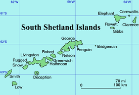
Location of Clarence Island in the South Shetland Islands.
.jpg)
Clarence Island seen from north-northeast with (left to right) Lebed Point, Sugarloaf Island and Cape Lloyd.
Location
Sugarloaf Island is located at 61°13′13″S 54°01′19.3″W, which is 3.2 km north of Lebed Point, on the north side of the entrance to Istros Bay.
Maps
- British Antarctic Territory. Scale 1:200000 topographic map. DOS 610 Series, Sheet W 61 54. Directorate of Overseas Surveys, Tolworth, UK, 1972.
- South Shetland Islands: Elephant, Clarence and Gibbs Islands. Scale 1:220000 topographic map. UK Antarctic Place-names Committee, 2009.
- Antarctic Digital Database (ADD). Scale 1:250000 topographic map of Antarctica. Scientific Committee on Antarctic Research (SCAR). Since 1993, regularly upgraded and updated.
gollark: My boat-flight spell doesn't actually work with me *in* the boat, which is proving a major obstacle.
gollark: Also with mods, ideally.
gollark: It's called Bedrock Edition.
gollark: Mojang keep horribly mucking it up even with foamfix and whatnot.,
gollark: Yes, especially modded.
References
| General |
| .svg.png) |
|---|---|---|
| Geographic regions | ||
| Waterways | ||
| Famous explorers | ||
This article is issued from Wikipedia. The text is licensed under Creative Commons - Attribution - Sharealike. Additional terms may apply for the media files.