Pordim Islands
Pordim Islands (Bulgarian: острови Пордим, ‘Ostrovi Pordim’ 'os-tro-vi 'por-dim) are two adjacent islands situated 870 m (950 yd) east-northeast of Heywood Island and 2.1 km (1.3 mi) northwest of Catharina Point on Robert Island, South Shetland Islands. Extending 960 m (1,050 yd) in east-southeast to west-northwest direction. The larger islet has a surface area of 10 hectares (25 acres).[1] Bulgarian early early mapping in 2009. Named after the town of Pordim in northern Bulgaria.
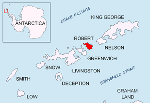 Location of Robert Island in the South Shetland Islands | |
 Pordim Islands Location of Pordim Islands  Pordim Islands Pordim Islands (Antarctic Peninsula) | |
| Geography | |
|---|---|
| Location | Antarctica |
| Coordinates | 62°18′41″S 59°39′33″W |
| Archipelago | South Shetland Islands |
| Area | 10 ha (25 acres)[1] |
| Administration | |
| Administered under the Antarctic Treaty System | |
| Demographics | |
| Population | uninhabited |
See also
- Composite Antarctic Gazetteer
- List of Antarctic islands south of 60° S
- SCAR
- Territorial claims in Antarctica
References
- L.L. Ivanov. Antarctica: Livingston Island and Greenwich, Robert, Snow and Smith Islands. Scale 1:120000 topographic map. Troyan: Manfred Wörner Foundation, 2009. ISBN 978-954-92032-6-4
External links
- Pordim Islands. SCAR Composite Antarctic Gazetteer
- Bulgarian Antarctic Gazetteer. Antarctic Place-names Commission. (details in Bulgarian, basic data in English)
External links
- Pordim Islands. Copernix satellite image
This article includes information from the Antarctic Place-names Commission of Bulgaria which is used with permission.

Topographic map of Livingston Island, Greenwich, Robert, Snow and Smith Islands.
| General |
| .svg.png) |
|---|---|---|
| Geographic regions | ||
| Waterways | ||
| Famous explorers | ||
This article is issued from Wikipedia. The text is licensed under Creative Commons - Attribution - Sharealike. Additional terms may apply for the media files.