Boyd Strait
Boyd Strait is the 40-kilometre (25 mi) wide strait lying between Snow Island and Smith Island in the South Shetland Islands, Antarctica, and linking Drake Passage and the Bransfield Strait.
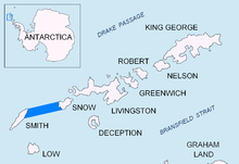
Location of Boyd Strait in the South Shetland Islands.

Topographic map of Livingston Island, Greenwich, Robert, Snow and Smith Islands.
The strait was named in 1823 by a British expedition under James Weddell for Captain David Boyd, Royal Navy.
Location
Boyd Strait is located at 62°50′S 62°00′W. British mapping in 1822 and 2008.
Maps
- Chart of South Shetland including Coronation Island, &c. from the exploration of the sloop Dove in the years 1821 and 1822 by George Powell Commander of the same. Scale ca. 1:200000. London: Laurie, 1822.
- South Shetland Islands : Map 3. Scale 1:200000. Cambridge: British Antarctic Survey, 2008.
gollark: Down?
gollark: `turtle.inspect`
gollark: I think it was GopherAtl or something.
gollark: I've seen someone with non-swarm smart mining, so presumably that would just need to be combined with the shared-map features in my swarm controller stuff, and delegation of roles, dropoff etc somehow.
gollark: Probably.
References
- Boyd Strait. SCAR Composite Antarctic Gazetteer

| General |
| .svg.png) |
|---|---|---|
| Geographic regions | ||
| Waterways | ||
| Famous explorers | ||
This article is issued from Wikipedia. The text is licensed under Creative Commons - Attribution - Sharealike. Additional terms may apply for the media files.