Istros Bay
Istros Bay (Bulgarian: залив Истрос, romanized: zaliv Istros, IPA: [ˈzalif ˈistros]) is the 3.2 km wide bay indenting for 1.4 km the east coast of Clarence Island in the South Shetland Islands, Antarctica. It is entered north of Lebed Point and south of Sugarloaf Island, and has its head fed by Highton Glacier. Istros is the ancient name for the lower Danube River.
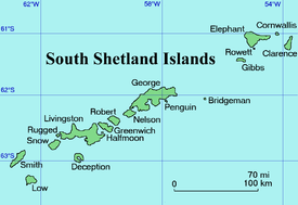
Location of Clarence Island in the South Shetland Islands.
.jpg)
Clarence Island seen from north-northeast with l(left to right) Lebed Point, Istros Bay, Sugarloaf Island and Cape Lloyd.
Location
Istros Bay is centred at 61°14′15″S 54°02′30″W. British mapping in 1972 and 2009.
Maps
- British Antarctic Territory. Scale 1:200000 topographic map. DOS 610 Series, Sheet W 61 54. Directorate of Overseas Surveys, Tolworth, UK, 1972.
- South Shetland Islands: Elephant, Clarence and Gibbs Islands. Scale 1:220000 topographic map. UK Antarctic Place-names Committee, 2009.
- Antarctic Digital Database (ADD). Scale 1:250000 topographic map of Antarctica. Scientific Committee on Antarctic Research (SCAR). Since 1993, regularly upgraded and updated.
gollark: You simply didn't notice.
gollark: I guessed years ago.
gollark: They have better power management nowadays.
gollark: Ignore neofetch, read the Intel spec sheet.
gollark: Not officially.
References
- Bulgarian Antarctic Gazetteer. Antarctic Place-names Commission. (details in Bulgarian, basic data in English)
- Istros Bay. SCAR Composite Gazetteer of Antarctica
External links
- Istros Bay. Copernix satellite image
This article includes information from the Antarctic Place-names Commission of Bulgaria which is used with permission.
This article is issued from Wikipedia. The text is licensed under Creative Commons - Attribution - Sharealike. Additional terms may apply for the media files.