Pisanitsa Island
Pisanitsa Island (Bulgarian: остров Писаница, romanized: ostrov Pisanitsa, IPA: [ˈɔstrof ˈpisɐnit͡sɐ]) is the rocky island in the Meade group off Archar Peninsula, the northwest extremity of Greenwich Island in the South Shetland Islands extending 270 m in southwest-northeast direction and 60 m wide. The area was visited by early 19th century sealers.
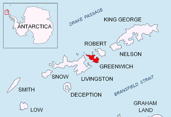 Location of Greenwich Island in the South Shetland Islands | |
 Pisanitsa Island Location of Pisanitsa Island  Pisanitsa Island Pisanitsa Island (Antarctic Peninsula) | |
| Geography | |
|---|---|
| Location | Antarctica |
| Coordinates | 62°26′48″S 60°03′14.5″W |
| Archipelago | South Shetland Islands |
| Administration | |
| Administered under the Antarctic Treaty System | |
| Demographics | |
| Population | Uninhabited |
The island is named after the settlement of Pisanitsa in Southern Bulgaria.
Location
Pisanitsa Island is located 1.26 km west by north of Duff Point, 120 m northeast of Cave Island and 3.6 km southeast of Pyramid Island. British mapping in 1968 and Bulgarian mapping in 2009.
Maps
- Livingston Island to King George Island. Scale 1:200000. Admiralty Nautical Chart 1776. Taunton: UK Hydrographic Office, 1968.
- L.L. Ivanov. Antarctica: Livingston Island and Greenwich, Robert, Snow and Smith Islands. Scale 1:120000 topographic map. Troyan: Manfred Wörner Foundation, 2009. ISBN 978-954-92032-6-4 (Second edition 2010, ISBN 978-954-92032-9-5)
- Antarctic Digital Database (ADD). Scale 1:250000 topographic map of Antarctica. Scientific Committee on Antarctic Research (SCAR). Since 1993, regularly upgraded and updated.
gollark: Maybe I should publish my entirely useless code with a custom license forbidding people who actively go around describing themselves as not caring about other people from using it.
gollark: Although that's kind of contradictory depending on what you're defining "bad" based on.
gollark: Well, you totally could, and that goes against the ethical frameworks most people agree with.
gollark: ...
gollark: So it had some positive effects, doesn't make it good on net.
References
- Bulgarian Antarctic Gazetteer. Antarctic Place-names Commission. (details in Bulgarian, basic data in English)
- Pisanitsa Island. SCAR Composite Antarctic Gazetteer.
External links
- Pisanitsa Island. Copernix satellite image
This article includes information from the Antarctic Place-names Commission of Bulgaria which is used with permission.

Topographic map of Livingston Island, Greenwich, Robert, Snow and Smith Islands
| General |
| .svg.png) |
|---|---|---|
| Geographic regions | ||
| Waterways | ||
| Famous explorers | ||
This article is issued from Wikipedia. The text is licensed under Creative Commons - Attribution - Sharealike. Additional terms may apply for the media files.