Leeve Island
Leeve Island (Bulgarian: остров Лееве, romanized: ostrov Leeve, IPA: [ˈɔstrof ˈlɛɛvɛ]) is the low ice-free island in the Onogur group off the northwest coast of Robert Island in the South Shetland Islands, Antarctica extending 200 m in southeast-northwest direction and 80 m wide. It is separated from Redina Island by a 100 m wide passage.
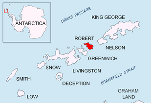 Location of Robert Island in the South Shetland Islands | |
 Leeve Island Location of Leeve Island  Leeve Island Leeve Island (Antarctic Peninsula) | |
| Geography | |
|---|---|
| Location | Antarctica |
| Coordinates | 62°21′10″S 59°40′58.5″W |
| Archipelago | South Shetland Islands |
| Administration | |
| Administered under the Antarctic Treaty System | |
| Demographics | |
| Population | Uninhabited |
The island is named after Leeve River in Rila Mountain, Bulgaria.
Location
Leeve Island is located 1.46 km to the north of Misnomer Point and 640 m west-southwest of Shipot Point. Bulgarian mapping in 2009.
Maps
- Livingston Island to King George Island. Scale 1:200000. Admiralty Nautical Chart 1776. Taunton: UK Hydrographic Office, 1968.
- L.L. Ivanov. Antarctica: Livingston Island and Greenwich, Robert, Snow and Smith Islands. Scale 1:120000 topographic map. Troyan: Manfred Wörner Foundation, 2009. ISBN 978-954-92032-6-4 (Second edition 2010, ISBN 978-954-92032-9-5)
- Antarctic Digital Database (ADD). Scale 1:250000 topographic map of Antarctica. Scientific Committee on Antarctic Research (SCAR). Since 1993, regularly upgraded and updated.
gollark: pjals/i02p/n64c/sillypotato.
gollark: Show CPU usage and RAM temp.
gollark: Just use arch Linux BTW.
gollark: iPhones are traitorous devices.
gollark: Hmm. I am now JEALOUSY.
References
- Leeve Island. SCAR Composite Antarctic Gazetteer.
- Bulgarian Antarctic Gazetteer. Antarctic Place-names Commission. (details in Bulgarian, basic data in English)
External links
- Leeve Island. Copernix satellite image
This article includes information from the Antarctic Place-names Commission of Bulgaria which is used with permission.

Topographic map of Livingston Island, Greenwich, Robert, Snow and Smith Islands.
| General |
| .svg.png) |
|---|---|---|
| Geographic regions | ||
| Waterways | ||
| Famous explorers | ||
This article is issued from Wikipedia. The text is licensed under Creative Commons - Attribution - Sharealike. Additional terms may apply for the media files.