Astor Island
Astor Island is an island lying between Rugged Island and Livingston Island in the South Shetland Islands, Antarctica. Surface area 12 hectares (30 acres).
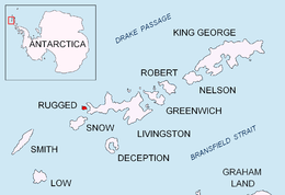 Location of Rugged Island in the South Shetland Islands. | |
 Astor Island Location of Rugged Island  Astor Island Astor Island (Antarctica) | |
| Geography | |
|---|---|
| Location | Antarctica |
| Coordinates | 62°38′22.8″S 61°10′15.4″W |
| Archipelago | South Shetland Islands |
| Area | 12 ha (30 acres) |
| Administration | |
| Administered under the Antarctic Treaty System | |
| Demographics | |
| Population | Uninhabited |
The feature was named by the United Kingdom Antarctic Place-Names Committee in 1958 for B. Astor of the New York Lyceum of Natural History (now the American Museum of Natural History).
Maps
- Península Byers, Isla Livingston. Mapa topográfico a escala 1:25000. Madrid: Servicio Geográfico del Ejército, 1992.
- L.L. Ivanov et al. Antarctica: Livingston Island and Greenwich Island, South Shetland Islands. Scale 1:100000 topographic map. Sofia: Antarctic Place-names Commission of Bulgaria, 2005.
- L.L. Ivanov. Antarctica: Livingston Island and Greenwich, Robert, Snow and Smith Islands. Scale 1:120000 topographic map. Troyan: Manfred Wörner Foundation, 2009. ISBN 978-954-92032-6-4
- L.L. Ivanov. Antarctica: Livingston Island and Smith Island. Scale 1:100000 topographic map. Manfred Wörner Foundation, 2017. ISBN 978-619-90008-3-0
gollark: It should, but mola appears to have *not* done that.
gollark: And so the processes it starts also close (unless they explicitly detach themselves).
gollark: Okay, that's easy then: your SSH session is closing.
gollark: Are you using a VPS or a random computer at home or what?
gollark: How are you starting/managing it?
See also
- Composite Antarctic Gazetteer
- List of Antarctic islands south of 60° S
- SCAR
- Territorial claims in Antarctica
External links
- SCAR Composite Antarctic Gazetteer.

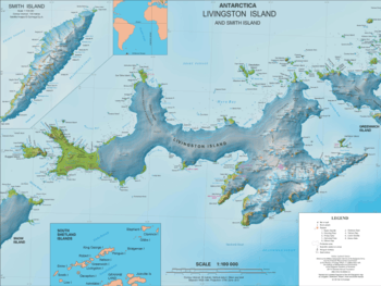
Topographic map of Livingston Island and Smith Island
| General |
| .svg.png) |
|---|---|---|
| Geographic regions | ||
| Waterways | ||
| Famous explorers | ||
This article is issued from Wikipedia. The text is licensed under Creative Commons - Attribution - Sharealike. Additional terms may apply for the media files.