Sierra Island
Sierra Island (62°24′S 59°48′W) is a narrow island which is marked by a series of small elevations throughout its length, lying 0.5 miles (0.8 km) northwest of Dee Island and north of Greenwich Island in the South Shetland Islands, Antarctica. Surface area 14 hectares (35 acres).[1]
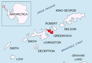 Location of Greenwich Island in the South Shetland Islands | |
 Sierra Island Location of Sierra Island  Sierra Island Sierra Island (Antarctica) | |
| Geography | |
|---|---|
| Location | Antarctica |
| Coordinates | 62°24′S 59°48′W |
| Archipelago | South Shetland Islands |
| Area | 14 ha (35 acres)[1] |
| Length | 0.5 mi (0.8 km) |
| Administration | |
| Administered under the Antarctic Treaty System | |
| Demographics | |
| Population | uninhabited |
Named by the 5th Chilean Antarctic Expedition, 1950–51, after Sgt. Victor Sierra, sick-bay attendant of the patrol ship Lientur on the expedition.
See also
- Composite Antarctic Gazetteer
- List of Antarctic islands south of 60° S
- SCAR
- Territorial claims in Antarctica
References
- L.L. Ivanov. Antarctica: Livingston Island and Greenwich, Robert, Snow and Smith Islands. Scale 1:120000 topographic map. Troyan: Manfred Wörner Foundation, 2009. ISBN 978-954-92032-6-4
External links
![]()
![]()

Topographic map of Livingston Island, Greenwich, Robert, Snow and Smith Islands
| General |
| .svg.png) |
|---|---|---|
| Geographic regions | ||
| Waterways | ||
| Famous explorers | ||
This article is issued from Wikipedia. The text is licensed under Creative Commons - Attribution - Sharealike. Additional terms may apply for the media files.