Logan County, Kansas
Logan County (standard abbreviation: LG) is a county located in the U.S. state of Kansas. As of the 2010 census, the county population was 2,756.[1] The largest city and county seat is Oakley.[2] The county was named for Gen. John A. Logan.[3]
Logan County | |
|---|---|
_from_E_1.JPG) Butterfield Trail Museum, formerly the Logan County courthouse, in Russell Springs, Kansas. | |
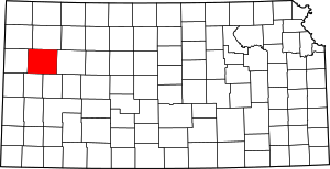 Location within the U.S. state of Kansas | |
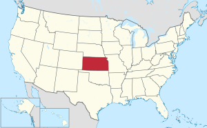 Kansas's location within the U.S. | |
| Coordinates: 38°54′N 101°06′W | |
| Country | |
| State | |
| Founded | February 24, 1887 |
| Named for | John A. Logan |
| Seat | Oakley |
| Largest city | Oakley |
| Area | |
| • Total | 1,073 sq mi (2,780 km2) |
| • Land | 1,073 sq mi (2,780 km2) |
| • Water | 0.1 sq mi (0.3 km2) 0.01%% |
| Population | |
| • Estimate (2018) | 2,844 |
| • Density | 2.6/sq mi (1.0/km2) |
| Time zone | UTC−6 (Central) |
| • Summer (DST) | UTC−5 (CDT) |
| Congressional district | 1st |
| Website | discoveroakley.com |

One of the county's most distinctive features is a mile long stretch of Smoky Hill Chalk bluffs that tower 100 feet (30 m) high over the Smoky Hill River and are dubbed "Little Jerusalem" for resembling the ancient walled city.[4] The formation is mostly on private land. In 2016, the Nature Conservancy purchased the property and the Little Jerusalem Badlands State Park opened to the public in October, 2019.[5]
History
Early history
For many millennia, the Great Plains of North America was inhabited by nomadic Native Americans. From the 16th century to 18th century, the Kingdom of France claimed ownership of large parts of North America. In 1762, after the French and Indian War, France secretly ceded New France to Spain, per the Treaty of Fontainebleau.
19th century
In 1802, Spain returned most of the land to France, but keeping title to about 7,500 square miles. In 1803, most of the land for modern day Kansas was acquired by the United States from France as part of the 828,000 square mile Louisiana Purchase for 2.83 cents per acre.
In 1854, the Kansas Territory was organized, then in 1861 Kansas became the 34th U.S. state. In 1887, Logan County was established.
Logan County was first created in 1871 as St. John County. St. John was formed from the area to the east of range 38 in what was then part of Wallace County. The Kansas State Legislature changed the name from St. John to Logan in 1885.[6]
Geography
According to the U.S. Census Bureau, the county has a total area of 1,073 square miles (2,780 km2), of which 1,073 square miles (2,780 km2) is land and 0.1 square miles (0.26 km2) (0.01%) is water.[7]
Major highways


Adjacent counties
- Thomas County (north)
- Gove County (east)
- Scott County (southeast)
- Wichita County (south)
- Wallace County (west/Mountain Time border)
- Sherman County (northwest/Mountain Time border)
Demographics
| Historical population | |||
|---|---|---|---|
| Census | Pop. | %± | |
| 1890 | 3,384 | — | |
| 1900 | 1,962 | −42.0% | |
| 1910 | 4,240 | 116.1% | |
| 1920 | 3,223 | −24.0% | |
| 1930 | 4,145 | 28.6% | |
| 1940 | 3,688 | −11.0% | |
| 1950 | 4,206 | 14.0% | |
| 1960 | 4,036 | −4.0% | |
| 1970 | 3,814 | −5.5% | |
| 1980 | 3,478 | −8.8% | |
| 1990 | 3,081 | −11.4% | |
| 2000 | 3,046 | −1.1% | |
| 2010 | 2,756 | −9.5% | |
| Est. 2018 | 2,844 | [8] | 3.2% |
| U.S. Decennial Census[9] 1790-1960[10] 1900-1990[11] 1990-2000[12] 2010-2016[1] | |||

At the 2000 census,[13] there were 3,046 people, 1,243 households and 856 families residing in the county. The population density was 3 per square mile (1/km²). There were 1,423 housing units at an average density of 1 per square mile (1/km²). The racial makeup of the county was 96.72% White, 0.59% Black or African American, 0.16% Native American, 0.20% Asian, 0.72% from other races, and 1.61% from two or more races. 1.64% of the population were Hispanic or Latino of any race.
There were 1,243 households of which 29.50% had children under the age of 18 living with them, 59.30% were married couples living together, 6.30% had a female householder with no husband present, and 31.10% were non-families. 28.60% of all households were made up of individuals and 14.80% had someone living alone who was 65 years of age or older. The average household size was 2.40 and the average family size was 2.98.
Age distribution was 25.40% under the age of 18, 7.20% from 18 to 24, 24.40% from 25 to 44, 22.30% from 45 to 64, and 20.70% who were 65 years of age or older. The median age was 41 years. For every 100 females there were 93.60 males. For every 100 females age 18 and over, there were 93.00 males.
The median household income was $32,131, and the median family income was $40,104. Males had a median income of $28,105 versus $19,609 for females. The per capita income for the county was $17,294. About 4.70% of families and 7.30% of the population were below the poverty line, including 7.80% of those under age 18 and 8.60% of those age 65 or over.
Government
Presidential elections
| Year | Republican | Democratic | Third Parties |
|---|---|---|---|
| 2016 | 83.4% 1,132 | 11.0% 149 | 5.6% 76 |
| 2012 | 83.4% 1,126 | 14.6% 197 | 2.0% 27 |
| 2008 | 82.4% 1,187 | 15.6% 225 | 1.9% 28 |
| 2004 | 82.4% 1,255 | 16.3% 248 | 1.3% 20 |
| 2000 | 77.9% 1,088 | 16.5% 231 | 5.6% 78 |
| 1996 | 73.5% 1,155 | 18.8% 296 | 7.7% 121 |
| 1992 | 53.0% 905 | 20.8% 355 | 26.3% 449 |
| 1988 | 64.4% 988 | 32.8% 503 | 2.9% 44 |
| 1984 | 77.0% 1,235 | 20.7% 331 | 2.3% 37 |
| 1980 | 72.9% 1,261 | 20.7% 358 | 6.4% 111 |
| 1976 | 56.4% 957 | 40.9% 694 | 2.7% 46 |
| 1972 | 70.0% 1,164 | 25.7% 428 | 4.3% 71 |
| 1968 | 63.8% 1,120 | 23.4% 411 | 12.8% 225 |
| 1964 | 49.8% 967 | 49.3% 957 | 0.9% 17 |
| 1960 | 65.2% 1,243 | 34.2% 651 | 0.6% 12 |
| 1956 | 72.6% 1,328 | 27.0% 493 | 0.4% 8 |
| 1952 | 80.0% 1,544 | 19.1% 369 | 0.9% 18 |
| 1948 | 63.7% 1,105 | 33.4% 579 | 2.9% 50 |
| 1944 | 72.9% 1,107 | 26.8% 406 | 0.3% 5 |
| 1940 | 66.8% 1,201 | 32.5% 584 | 0.7% 12 |
| 1936 | 51.2% 955 | 48.6% 908 | 0.2% 4 |
| 1932 | 44.3% 867 | 52.3% 1,025 | 3.4% 67 |
| 1928 | 71.6% 1,066 | 27.2% 405 | 1.1% 17 |
| 1924 | 63.9% 942 | 19.4% 286 | 16.8% 247 |
| 1920 | 68.5% 781 | 27.4% 312 | 4.1% 47 |
| 1916 | 42.1% 592 | 50.4% 709 | 7.6% 107 |
| 1912 | 20.2% 166 | 31.6% 259 | 48.2% 396[lower-alpha 1] |
| 1908 | 59.3% 524 | 34.9% 308 | 5.8% 51 |
| 1904 | 71.8% 408 | 20.6% 117 | 7.6% 43 |
| 1900 | 60.5% 319 | 33.4% 176 | 6.1% 32 |
| 1896 | 60.4% 274 | 38.6% 175 | 1.1% 5 |
| 1892 | 58.1% 457 | 41.9% 329 | |
| 1888 | 65.8% 609 | 30.6% 283 | 3.6% 33 |
Like all the High Plains, Logan County is overwhelmingly Republican. Only two Democrats have ever carried the county in a Presidential election: Woodrow Wilson in 1916 and Franklin D. Roosevelt in 1932. Since at least 1888 only three other Democrats have passed forty percent of the county's vote: Roosevelt in 1936, Lyndon Johnson in 1964 and Jimmy Carter in 1976. In fact, apart from Michael Dukakis in 1988 during an election held during the grip of a major Plains drought, no Democrat since 1980 has passed 21 percent of the county's vote.
Education
Unified school districts
- Oakley USD 274
- Triplains USD 275
Communities

Cities
Unincorporated communities
Townships
Logan County is divided into eleven townships. None of the cities within the county is considered governmentally independent, and all figures for the townships include those of the cities.
In the following table, the population center is the largest city (or cities) included in that township's population total, if it is of a significant size.
| Township | FIPS | Population center |
Population | Population density /km² (/sq mi) |
Land area km² (sq mi) | Water area km² (sq mi) | Water % | Geographic coordinates |
|---|---|---|---|---|---|---|---|---|
| Augustine | 03350 | 26 | 0 (0) | 187 (72) | 0 (0) | 0% | 38°44′14″N 101°21′15″W | |
| Elkader | 20225 | 15 | 0 (0) | 278 (107) | 0 (0) | 0.01% | 38°53′33″N 100°52′1″W | |
| Lees | 39200 | 17 | 0 (0) | 185 (72) | 0 (0) | 0% | 38°44′26″N 100°59′5″W | |
| Logansport | 42325 | 14 | 0 (0) | 278 (107) | 0 (0) | 0.01% | 38°51′29″N 101°4′9″W | |
| McAllaster | 43600 | 29 | 0 (0) | 276 (106) | 0 (0) | 0.01% | 39°2′58″N 101°22′4″W | |
| Monument | 48050 | 144 | 1 (1) | 276 (107) | 0 (0) | 0% | 39°4′17″N 101°2′42″W | |
| Oakley | 51850 | Oakley | 2,343 | 8 (22) | 278 (107) | 0 (0) | 0.01% | 39°6′43″N 100°51′32″W |
| Paxton | 55025 | 24 | 0 (0) | 186 (72) | 0 (0) | 0% | 38°44′38″N 101°7′57″W | |
| Russell Springs | 61900 | 71 | 0 (1) | 279 (108) | 0 (0) | 0.03% | 38°53′16″N 101°12′15″W | |
| Western | 76900 | 44 | 0 (0) | 279 (108) | 0 (0) | 0.04% | 38°54′3″N 101°24′37″W | |
| Winona | 80100 | Winona | 319 | 1 (3) | 277 (107) | 0 (0) | 0% | 39°3′53″N 101°12′54″W |
See also
- Dry counties
|
|
References
- "State & County QuickFacts". United States Census Bureau. Archived from the original on June 6, 2011. Retrieved July 26, 2014.
- "Find a County". National Association of Counties. Retrieved 2011-06-07.
- Blackmar, Frank Wilson (1912). Kansas: A Cyclopedia of State History, Volume 2. Standard Publishing Company. pp. 180.
- "Little Jerusalem Badlands State Park". Places We Protect www.nature.org. The Nature Conservancy. Retrieved 2019-10-16.
The chalk outcroppings have had many names. In the late 19th century, they were said to resemble the ruins of many castles, thus “Castle City.” Some say that it got the name “Little Jerusalem” or “New Jerusalem” because from a distance it looks like the ancient walled city of Jerusalem. By the time The Nature Conservancy acquired the property, most modern-day locals and geologists knew it by the name of Little Jerusalem.
- http://www.kansascity.com/news/state/kansas/article107863027.html
- Blackmar, Frank Wilson (1912). Kansas: A Cyclopedia of State History, Volume 2. Chicago: Standard Publishing Company. pp. 180–181.
- "US Gazetteer files: 2010, 2000, and 1990". United States Census Bureau. 2011-02-12. Retrieved 2011-04-23.
- "Population and Housing Unit Estimates". Retrieved December 23, 2019.
- "U.S. Decennial Census". United States Census Bureau. Retrieved July 26, 2014.
- "Historical Census Browser". University of Virginia Library. Retrieved July 26, 2014.
- "Population of Counties by Decennial Census: 1900 to 1990". United States Census Bureau. Retrieved July 26, 2014.
- "Census 2000 PHC-T-4. Ranking Tables for Counties: 1990 and 2000" (PDF). United States Census Bureau. Retrieved July 26, 2014.
- "U.S. Census website". United States Census Bureau. Retrieved 2008-01-31.
- http://uselectionatlas.org/RESULTS
- "Map of Wet and Dry Counties". Alcoholic Beverage Control, Kansas Department of Revenue. November 2006. Archived from the original on 2007-10-08. Retrieved 2007-12-28.
- Notes
- This total comprises 315 votes (38.37 percent) for Progressive Theodore Roosevelt (who carried the county) and 81 votes (9.87 percent) for Socialist Eugene V. Debs.
Further reading
External links
| Wikimedia Commons has media related to Logan County, Kansas. |
- County
- Maps
- Logan County Maps: Current, Historic, KDOT
- Kansas Highway Maps: Current, Historic, KDOT
- Kansas Railroad Maps: Current, 1996, 1915, KDOT and Kansas Historical Society
Places adjacent to Logan County, Kansas | ||||||||||
|---|---|---|---|---|---|---|---|---|---|---|
| ||||||||||
Municipalities and communities of Logan County, Kansas, United States | ||
|---|---|---|
| Cities | Map of Kansas highlighting Logan County | |
| Unincorporated communities | ||
| Ghost towns | ||
| Footnotes | ‡This populated place also has portions in an adjacent county or counties | |
| Authority control |
|
|---|