Oaklawn-Sunview, Kansas
Oaklawn-Sunview is an unincorporated community in Sedgwick County, Kansas, United States. At the 2000 census, its population was 3,135. It is located on the south side of Wichita along the west side of K-15 (Southeast Blvd) and 47th Street South intersection.
Oaklawn-Sunview, Kansas | |
|---|---|
 Location within Sedgwick County and Kansas | |
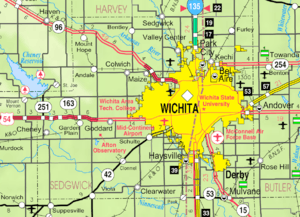 KDOT map of Sedgwick County (legend) | |
 Oaklawn-Sunview Location within Sedgwick County and Kansas  Oaklawn-Sunview Oaklawn-Sunview (the United States) | |
| Coordinates: 37°36′30″N 97°17′46″W | |
| Country | United States |
| State | Kansas |
| County | Sedgwick |
| Area | |
| • Total | 0.5 sq mi (1.4 km2) |
| • Land | 0.5 sq mi (1.4 km2) |
| • Water | 0.0 sq mi (0.0 km2) |
| Elevation | 1,270 ft (390 m) |
| Population (2010) | |
| • Total | 3,135 |
| • Density | 6,300/sq mi (2,200/km2) |
| Time zone | UTC-6 (CST) |
| • Summer (DST) | UTC-5 (CDT) |
| Area code | 316 |
| FIPS code | 20-51810 [1] |
Geography
Oaklawn-Sunview is located at 37°36′30″N 97°17′46″W (37.608463, -97.296045).[2] According to the United States Census Bureau, the community has a total area of 0.5 square miles (1.3 km2), all of it land.
Demographics
| Historical population | |||
|---|---|---|---|
| Census | Pop. | %± | |
| 1990 | 3,240 | — | |
| 2000 | 3,155 | −2.6% | |
| U.S. Decennial Census | |||
For statistical purposes, the United States Census Bureau has defined Oaklawn-Sunview as a census-designated place (CDP).
2000
At the 2000 census,[1] there were 3,135 people, 1,056 households and 785 families residing in the community. The population density was 5,823.1 per square mile (2,241.5/km2). There were 1,179 housing units at an average density of 2,189.9/sq mi (843.0/km2). The racial makeup of the community was 62.7% White, 8.9% African American, 2.4% Native American, 15.5% Asian, <0.1% Pacific Islander, 5.4% from other races, and 5.1% from two or more races. Hispanic or Latino of any race were 11.4% of the population.
There were 1,056 households of which 44.1% had children under the age of 18 living with them, 49.1% were married couples living together, 17.0% had a female householder with no husband present, and 25.6% were non-families. 20.3% of all households were made up of individuals and 4.9% had someone living alone who was 65 years of age or older. The average household size was 2.97 and the average family size was 3.47.
35.1% of the population were under the age of 18, 10.9% from 18 to 24, 30.6% from 25 to 44, 16.7% from 45 to 64, and 6.7% who were 65 years of age or older. The median age was 27 years. For every 100 females, there were 102.5 males. For every 100 females age 18 and over, there were 100.2 males.
The median household income was $34,292 and the median family income was $35,978. Males had a median income of $30,956 vand females $20,172. The per capita income was $12,564. About 16.2% of families and 18.3% of the population were below the poverty line, including 20.8% of those under age 18 and 22.2% of those age 65 or over.
Education
The community is served by Derby USD 260 public school district.
References
- "U.S. Census website". United States Census Bureau. Retrieved January 31, 2008.
- "US Gazetteer files: 2010, 2000, and 1990". United States Census Bureau. February 12, 2011. Retrieved April 23, 2011.
Further reading
External links
- Wichita city map, KSDOT
- Sedgwick County Maps: Current, Historic, KDOT
Municipalities and communities of Sedgwick County, Kansas, United States | ||
|---|---|---|
| Cities | 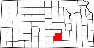 Map of Kansas highlighting Sedgwick County | |
| Unincorporated CDPs | ||
| Unincorporated communities | ||
| Townships | ||
| Footnotes | ‡This populated place also has portions in an adjacent county or counties | |