Interstate 430
Interstate 430 (I-430) is a 12.93 miles (20.81 km) long Interstate highway in Pulaski County, Arkansas that bypasses the cities of Little Rock and North Little Rock. I-430 begins at an interchange southwest of Downtown Little Rock with I-30, U.S. Route 67 and U.S. 70 and travels north to cross the Arkansas River and end at I-40 and U.S. 65. The first plans for the freeway appeared in 1955.
| ||||
|---|---|---|---|---|
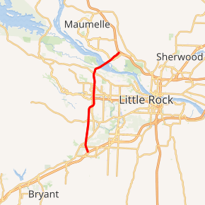
I-430 highlighted in red | ||||
| Route information | ||||
| Auxiliary route of I-30 | ||||
| Maintained by ArDOT | ||||
| Length | 12.93 mi[1] (20.81 km) | |||
| Existed | early 1980s–present | |||
| Major junctions | ||||
| South end | ||||
| North end | ||||
| Location | ||||
| Counties | Pulaski | |||
| Highway system | ||||
| ||||
.svg.png)
Route description
Interstate 430 (I-430) starts its 12.93 miles (20.81 km) route at a trumpet interchange with I-30, U.S. Route 67 (U.S. 67) and U.S. 70. From the interchange, I-430 travels northwest and runs over Highway 338 (AR 338) before having a diamond interchange with AR 5. The freeway goes north to pass Remington College and intersect Colonel Glenn Road before curving eastward to intersect Shackleford Road and then turning back north. Immediately after going under Kanis Road, the highway has a cloverleaf interchange with Interstate 630 at its western terminus. After I-630, the roadway goes past Immanuel Baptist Church and Breckenridge Village to intersect Rodney Parham Road near the Colony West Shopping Center and later AR 10. The AR 10 interchange was the final I-430 interchange before the freeway crossed the Arkansas River on the I-430 Bridge. After the bridge, the roadway passes Rosenbaum Lake and intersects with AR 100 before ending at a three-way interchange with I-40 and U.S. 65.[2]
History
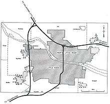
Early plans for the Interstate Highway System include a route along roughly the same alignment as the present Interstate 30 (I-30) through the Little Rock area, but are not detailed enough to show exactly how the cities would be served.[3] Later, in 1955, a map of the Interstate Highway's plans shows a complete beltway around Little Rock, including present-day I-430, I-440 and Highway 440 (AR 440).[4] When preliminary urban routes were laid out in 1955, the beltway was shortened to the current route of I-430.[5]
Exit list
The entire highway is in Pulaski County.
| Location | mi | km | Exit | Destinations | Notes |
|---|---|---|---|---|---|
| Little Rock | 0.00 | 0.00 | 129 | Southbound exit and northbound entrance; southern terminus and signed as left exit 129A (east) & 129B (west); uses I-30's exit numbers | |
| 0.19 | 0.31 | 128 | Mablevale West Road / Otter Creek Road / Bass Pro Parkway | Southbound exit to I-30 westbound service drive only; exit number corresponds to I-30 | |
| 1.25 | 2.01 | 1 | |||
| 3.59 | 5.78 | 4 | |||
| 5.34 | 8.59 | 5 | Shackleford Road / Kanis Road | ||
| 6.30 | 10.14 | 6 | I-630 exits 8A-B | ||
| 7.70 | 12.39 | 8 | Rodney Parham Road | ||
| 9.06 | 14.58 | 9 | |||
| North Little Rock | 11.63 | 18.72 | 12 | ||
| 12.83 | 20.65 | 13 | Northbound exit and southbound entrance; northern terminus and signed as exit 13A (east) & left 13B (west); I-40 exit 147; tri-stack interchange | ||
| 1.000 mi = 1.609 km; 1.000 km = 0.621 mi | |||||
References
- "Route Log - Auxiliary Routes of the Eisenhower National System Of Interstate and Defense Highways - Table 2". Federal Highway Administration. Retrieved 5 October 2014.
- Google (2009-03-10). "Interstate 430" (Map). Google Maps. Google. Retrieved 2009-03-10.
- Bureau of Public Roads, Proposed Interregional Highway System, 1939
- Bureau of Public Roads, National System of Interstate and Defense Highways, September 1955
- Bureau of Public Roads, General Location of National System of Interstate Highways, 1955
External links
1Future 2Cancelled | ||