Arkansas Highway 161
Highway 161 (AR 161, Ark. 161, and Hwy. 161) is a designation for two state highways in Central Arkansas.
| ||||
|---|---|---|---|---|
| ||||
| Route information | ||||
| Maintained by ArDOT | ||||
| Section 1 | ||||
| Length | 11.28 mi (18.15 km) | |||
| South end | ||||
| North end | Vandenberg Boulevard, Little Rock Air Force Base | |||
| Section 2 | ||||
| Length | 19.80 mi (31.87 km) | |||
| South end | ||||
| North end | ||||
| Location | ||||
| Counties | Pulaski, Lonoke | |||
| Highway system | ||||
| ||||


Route descriptions
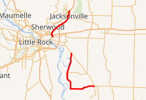
One route of 11.28 miles (18.15 km) runs north from US Highway 70 (US 70) to Vandenberg Boulevard near the Little Rock Air Force Base.[1] A second route of 19.80 miles (31.87 km) begins at U.S. Route 165/Highway 15/Highway 256 in England and runs north to terminate at Highway 165. Both routes are maintained by the Arkansas State Highway and Transportation Department (AHTD).
History
The 1959 Arkansas General Assembly passed and Governor Orval Faubus signed, Act 298, entitled "An Act to Remove a Part of State Highway 161 from the State Highway System" into law; removing a portion of Highway 161 between Faulkner Lake Rd and Highway 130 (present-day U.S. Route 165) from the state highway system. The rationale behind this legislation is not recorded in the minutes of the Arkansas State Highway Commission (ASHC) meeting, but the ASHC concurred with the General Assembly and removed the highway segment from the system on May 13, 1959.[2]
The section between Prothro Junction and Jacksonville was formerly designated as US 67E. The route became Highway 161 on August 31, 1960 upon completion of the new US 67 alignment between Little Rock and Jacksonville.[3] The ASHC closed a gap of 7.99 miles (12.86 km) along the Lonoke County segment of Highway 161 on December 13, 1972.[4] A segment between Cabot and El Paso was redesignated as Highway 5 on June 24, 1970.[5]
Major intersections
| County | Location | mi | km | Destinations | Notes | ||
|---|---|---|---|---|---|---|---|
| Pulaski | Prothro Junction | 0.00 | 0.00 | Southern terminus | |||
| North Little Rock | 0.87 | 1.40 | I-40 exit 157. | ||||
| Jacksonville | 5.61 | 9.03 | I-440 exit 12. | ||||
| 8.36 | 13.45 | AR 294 western terminus | |||||
| 11.19 | 18.01 | ||||||
| Little Rock Air Force Base | 11.28 | 18.15 | Vandenberg Boulevard | Northern terminus | |||
| Gap in route | |||||||
| Lonoke | England | 0.00 | 0.00 | Southern terminus | |||
| Scott | 19.71 | 31.72 | Northern terminus | ||||
| 1.000 mi = 1.609 km; 1.000 km = 0.621 mi | |||||||
See also
References
- General Highway Map, Pulaski County, Arkansas (PDF) (Map). 1:62500. Cartography by Transportation Planning & Policy Division. Arkansas State Highway and Transportation Department. 2016-03-23. Retrieved 2016-06-28.
- "Minute Order 3244" (PDF). Minutes of the Meeting. Arkansas State Highway Commission. 1960-08-31. p. 1472. Retrieved 2016-06-28.
- "Minute Order 3837" (PDF). Minutes of the Meeting. Arkansas State Highway Commission. 1960-08-31. p. 1380. Retrieved 2016-06-28.
- "Minute Order 3837" (PDF). Minutes of the Meeting. Arkansas State Highway Commission. 1972-12-13. pp. 1416–1417. Retrieved 2016-06-28.
- "Minute Order 70-196" (PDF). Minutes of the Meeting. Arkansas State Highway Commission. 1970-06-24. p. 1636. Retrieved 2016-06-28.
External links
![]()