Pellissippi Parkway
The Pellissippi Parkway is a highway in Knox and Blount counties in Tennessee. It extends from SR 62 (Oak Ridge Highway) at Solway in Knox County to a terminus east of US 129 (Alcoa Highway) at SR 33 (Old Knoxville Highway) in Blount County. The central portion of the Pellissippi Parkway is included in the Interstate Highway system and is designated Interstate 140 (I-140), while portions at either end (a 5.9-mile (9.5 km) long section in Knox County and a short section in Blount County) are designated State Route 162 (SR 162), a north–south primary highway.
| |||||||
|---|---|---|---|---|---|---|---|
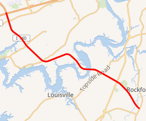
I-140 portion is highlighted in red | |||||||
| Route information | |||||||
| Maintained by TDOT | |||||||
| Length | 19.7 mi[1] (31.7 km) | ||||||
| Component highways | |||||||
| Major junctions | |||||||
| Western end | |||||||
| Current Eastern end | |||||||
| Location | |||||||
| Counties | Knox, Blount | ||||||
| Highway system | |||||||
| |||||||


Route description
Pellissippi Parkway comprises I-140 and two sections of SR 162 that seamlessly extend from either end of the Interstate highway. The northern segment of SR 162 runs 5.9 miles (9.5 km) from SR 62 at Solway south to I-40 and I-75 in Knoxville.[2] I-140 has a length of 11.17 miles (17.98 km) from the junction with I-40 and I-75 to US 129 in Alcoa.[3][4] The southern segment of SR 162 begins at US 129 and runs 2.7 miles (4.3 km) to SR 33 within Alcoa.[5] Pellissippi Parkway from Solway to US 129 is a part of the National Highway System.[6] The predominant roadway configuration along the route is a four-lane divided cross-section.[7]
Solway to Knoxville
Pellissippi Parkway begins at SR 162's northern terminus at a directional interchange with SR 62 (Oak Ridge Highway) at the east end of the village of Solway on the east side of the Clinch River from Oak Ridge. There is no direct access from westbound SR 62 to the parkway. Pellissippi Parkway heads southeast as a limited-access four-lane divided highway. The highway crosses Beaver Creek and has a four-ramp partial cloverleaf interchange with Hardin Valley Road, which leads to Pellissippi State Community College. Pellissippi Parkway has another partial cloverleaf interchange with SR 131 (Lovell Road).
The highway becomes a freeway at its last at-grade intersection just northwest of its partial cloverleaf interchange with Dutchtown Road. There, Pellissippi Parkway enters the western end of the city of Knoxville, expands to six lanes, and is paralleled on both sides by frontage roads south to the parkway's interchange with I-40 and I-75, where SR 162's northern segment ends and I-140 begins. That interchange is a cloverleaf interchange with a flyover ramp from southbound SR 162 toward eastbound I-40 and northbound I-75, which head concurrently toward downtown Knoxville.[1]
Knoxville to Alcoa
Pellissippi Parkway continues south through a partial cloverleaf interchange with Kingston Pike, which carries US 11 and US 70. South of Kingston Pike, the freeway passes along a sliver of the city of Knoxville that follows the freeway to the Tennessee River. Pellissippi Parkway crosses a Norfolk Southern Railway line and the Sinking Creek arm of Fort Loudon Lake ahead of its diamond interchange with Westland Drive. The freeway curves east within its diamond interchange with SR 332 (Northshore Drive); the interchange includes a ramp from the eastbound parkway to Town Center Boulevard. Pellissippi Parkway veers south onto a peninsula within a bend of the Tennessee River, then curves east again to cross the river, which forms the Knox–Blount county line.
At the east side of the river, Pellissippi Parkway enters the city of Alcoa, within which the highway remains to its eastern end. The freeway has a diamond interchange with SR 333 (Topside Road) and crosses a CSX rail line. Pellissippi Parkway curves southeast through a cloverleaf interchange with US 129 (Alcoa Highway), where I-140 ends and the southern segment of SR 162 begins. The freeway has an southbound-only exit and northbound-only entrance from and to Cusick Road and crosses a Norfolk Southern rail line before reaching its terminus at a half-diamond interchange at SR 33 (Old Knoxville Highway) in Eagleton Village.[1]
History
When first built, the Pellissippi Parkway was a four-lane divided highway in Knox County, extending from State Route 62 at Solway to an interchange with I-40/I-75 in western Knox County. This segment was completed in 1971.[8] Plans for extending the Pellissippi Parkway from I-40/I-75 in Knox County into Blount County first appeared in a 1973 statewide transportation plan, and in April 1975, the Tennessee General Assembly passed a resolution authorizing TDOT to study the possibility of extending the route east to the Alcoa Highway.[8] The extension did not receive funding until the passage of the Better Roads Program of 1986, an initiative by then-governor Lamar Alexander to fund a backlog of needed road projects throughout the state.[9] This part of the parkway was constructed in four sections beginning in 1987.[9] The first section, a 6.6 miles (10.6 km) segment which crosses the Tennessee River to connect US 129 in Blount County with SR 332 in Knox County, was completed on December 4, 1992, providing more efficient access to the McGhee Tyson Airport from Oak Ridge and Farragut.[10] The bridge across the Tennessee River was completed in August 1990 but not opened to traffic.[11] The next segment completed was the 4 miles (6.4 km) segment between SR 332 and Kingston Pike on October 6, 1993.[12] The Mabry Hood House, an antebellum home located on the south side of Kingston Pike, was demolished in this project. The next section, located between Kingston Pike and I-40/I-75 which expanded the interchange with I-40/I-75, opened on December 16, 1996, with construction of the ramps completed in the Spring of 1997.[13] The 1.1 miles (1.8 km) segment between US 129 and Cusick Road opened on December 22, 1996.[14] On August 15, 2005 the most recent section, located between Cusick Road and SR 33, was opened. Plans call for extending the highway eastward about 4.4 miles (7.1 km) to U.S. Route 321 (Tennessee State Route 73) in Blount County.[15]
As of 2003, SR 162 was applied to an 5.9-mile (9.5 km) long route in Knox County; its southern terminus was with I-40 where I-140 begins, and its northern terminus was with State Route 62 at Solway. Additionally, as of 2005 the eastward highway extension of I-140 east of U.S. Route 129 (Alcoa Highway) in Blount County, Tennessee was signed as SR 162. Originally, the highway that is now designated as I-140 was designated SR 162 and Pellissippi Parkway. The state route designation was dropped when the central portion was accepted into the Interstate Highway system as I-140, but the entire route of SR 162 and I-140 from Solway to US 129 is still known as Pellissippi Parkway.
Origin of name
Pellissippi (also spelled "Pelisipi") appears on early maps as the name of the Clinch River.
Future
A 4.4 mile extension project in Blount County from SR 33 (Old Knoxville Highway) to a terminus at SR 73/US 321 East (Lamar Alexander Parkway) between Maryville & Walland has undergone a number of delays and court reviews since the 1990s. An exit is proposed at US 411 in Maryville. [16]
Exit list
| County | Location | mi [1] | km | Exit | Destinations | Notes |
|---|---|---|---|---|---|---|
| Knox | Solway | 0.0 | 0.0 | – | Northern terminus of SR 162; directional interchange; no direct access from westbound SR 62 to southbound SR 162 | |
| | 2.4 | 3.9 | – | Hardin Valley Road – Pellissippi State Community College | Partial cloverleaf interchange | |
| | 3.6 | 5.8 | – | Partial cloverleaf interchange | ||
| Knoxville | 4.6 | 7.4 | – | Dutchtown Road | Partial cloverleaf interchange | |
| 5.9 | 9.5 | 1 C-D | Southern terminus of northern segment of SR 162; western terminus of I-140; split into exits 1C (I-40 east / I-75 north) and 1D (I-40 west / I-75 south) westbound; I-40/75 exits 376A-B | |||
| 6.4 | 10.3 | 1 A-B | Split into exits 1A (US 11 north / US 70 east) and 1B eastbound (US 11 south / US 70 west) | |||
| 8.8 | 14.2 | 3 | Westland Drive | |||
| 10.5 | 16.9 | 5 | Access to Town Center Boulevard from eastbound I-140 only | |||
| Tennessee River | 14.5– 14.8 | 23.3– 23.8 | Bridge across Fort Loudon Lake | |||
| Blount | Alcoa | 15.6 | 25.1 | 9 | ||
| 17.0 | 27.4 | 11 A-B | Eastern terminus of I-140; northern terminus of southern segment of SR 162; split into exits 11A (south) and 11B (north) | |||
| 17.7 | 28.5 | – | Cusick Road | Southbound exit and northbound entrance only, no exit number | ||
| Eagleton Village | 19.7 | 31.7 | 14 | Current southern terminus of SR 162 and Pellissippi Parkway | ||
1.000 mi = 1.609 km; 1.000 km = 0.621 mi
| ||||||
Traffic
As of 2010, daily traffic counts on the Pellissippi Parkway corridor ranged from 29,500 to 65,400.[7]
References
- Google (2013-08-18). "Pellissippi Parkway" (Map). Google Maps. Google. Retrieved 2013-08-18.
- Google (2013-08-18). "Tennessee State Route 162 (northern section)" (Map). Google Maps. Google. Retrieved 2013-08-18.
- DeSimone, Tony (October 31, 2002). "Table 2: Auxiliary Routes of the Dwight D. Eisenhower National System Of Interstate and Defense Highways as of October 31, 2002". FHWA Route Log and Finder List. Federal Highway Administration. Retrieved 2013-08-18.
- Google (2013-08-18). "Interstate 140" (Map). Google Maps. Google. Retrieved 2013-08-18.
- Google (2013-08-18). "Tennessee State Route 162 (southern section)" (Map). Google Maps. Google. Retrieved 2013-08-18.
- National Highway System: Knoxville, TN (PDF) (Map). Federal Highway Administration. October 1, 2012. Retrieved 2013-08-18.
- Knoxville Regional Transportation Planning Organization (March 2013). "Knoxville Regional Transit Corridor Study Final Report" (PDF). pp. 10–11.
- Tennessee Department of Highways (1984). Pellissippi Parkway Extension, I-40-I-75 to TN-115: Environmental Impact Statement (Report). Federal Highway Administration. Retrieved 2018-11-20.
- U.S. Department of Transportation, Federal Highway Administration, and Tennessee Department of Transportation, Draft Environmental Impact Statement, Pellissippi Parkway Extension (SR 162), From SR 33 (Old Knoxville Highway) to US 321/SR 73/Lamar Alexander Parkway, Blount County, Tennessee, April 2010
- "Traffic Travels Over New Part of Pellissippi; More than 1,500 Cars an Hour Figured". Knoxville News-Sentinel. December 5, 1992.
- "Pellissippi Parkway Extension Eventually will Link three ET Counties". Knoxville News-Sentinel. October 28, 1990.
- "New Portion of Pellissippi Parkway Opens". Knoxville News-Sentinel. October 7, 1993.
- "Pellissippi Parkway Link Opens". Knoxville News-Sentinel. December 18, 1996.
- "Alcoa Highway To Cusick Road Stretch Opens". Knoxville News-Sentinel. December 22, 1996.
- "State Route 162 (Pellissippi Parkway Extension)". Tennessee Department of Transportation. Archived from the original on January 10, 2007. Retrieved July 24, 2013.
- "Decision Made for Pellissippi Parkway Extension (SR 162) Project; West alignment shift at southern end of Preferred Alternative selected". news.tn.gov. Tennessee Department of Transportation. July 29, 2013. Archived from the original on 2013-08-25. Retrieved January 8, 2015.