Clarke County, Virginia
Clarke County is a county in the Commonwealth of Virginia. As of the 2010 census, the population was 14,034.[1] Its county seat is Berryville.[2] Clarke County is included in the Washington-Arlington-Alexandria, DC-VA-MD-WV Metropolitan Statistical Area.
Clarke County | |
|---|---|
County | |
| County of Clarke | |
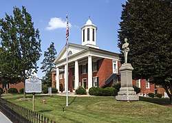 Old Clarke County Courthouse and Confederate monument | |
 Flag  Seal | |
 Location within the U.S. state of Virginia | |
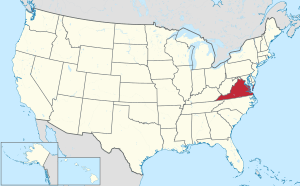 Virginia's location within the U.S. | |
| Coordinates: 39°07′N 78°00′W | |
| Country | |
| State | |
| Founded | 1836 |
| Named for | George Rogers Clark |
| Seat | Berryville |
| Largest town | Berryville |
| Area | |
| • Total | 178 sq mi (460 km2) |
| • Land | 176 sq mi (460 km2) |
| • Water | 2.2 sq mi (6 km2) 1.2% |
| Population (2010) | |
| • Total | 14,034 |
| • Estimate (2018) | 14,523 |
| • Density | 79/sq mi (30/km2) |
| Time zone | UTC−5 (Eastern) |
| • Summer (DST) | UTC−4 (EDT) |
| Congressional district | 10th |
| Website | clarkecounty |
History
The first settlement of the Virginia Colony in the future Clarke County was in 1736 by Thomas Fairfax, 6th Lord Fairfax of Cameron who built a home, Greenway Court, on part of his 5 million acres (20,000 km2) property, near what is now the village of White Post. White Post was named for the large signpost pointing the way to Lord Fairfax's home.
As it lay just west of the Blue Ridge border demarcated under Governor Spotswood at Albany in 1722, the area was claimed along with the rest of the Shenandoah Valley by the Six Nations Iroquois (who had overrun it during the later Beaver Wars in around 1672), until the Treaty of Lancaster in 1744, when it was purchased from them by Governor Gooch.
Many of the early settlers of what became Clarke County were children of Tidewater planters, who settled on large land grants from Lord Fairfax. Two-thirds of the county was settled by the plantation group, and the plantation lifestyle thrived until the Civil War. County status came in 1836 when it was divided off from Frederick County. Clarke was known for its large crops of wheat.
During the American Civil War, John S. Mosby, "the Gray Ghost" of the Confederacy, raided General Sheridan's supply train in the summer of 1864, in Berryville. The Battle of Cool Spring was fought in Clarke County on July 17 and 18th, 1864, and the Battle of Berryville on September 3, 1864.
In 1881 was founded the Bank of Clarke County, still functional regional bank headquartered in Berryville.[3]
Early in the 20th century, future Virginia politician Harry F. Byrd, Sr. and his wife established their first home near Berryville, where he undertook extensive agricultural activity growing peaches and apples. Byrd became a State senator in the upper house of the Virginia General Assembly, served a term as a Governor of Virginia, and was a United States Senator for over 30 years, heading the powerful Byrd Organization which dominated state politics between the mid-1920s and 1960s.
In 1996, Forrest Pritchard revitalized Smithfield Farm by starting a grass-fed, sustainable livestock operation. Renamed 'Smith Meadows', it is currently one of the oldest fully grass-finished farms in the United States, and its story was chronicled in the New York Times bestseller Gaining Ground.
Historic buildings and structures
- Clermont Estate (1751)
- Dearmont Hall (1850)
- Fairfield (1765)
- Soldier's Rest (1769)
- Buck Marsh Church (1772)
- Norwood (1780)
- Burwell-Morgan Mill (1782)
- Holy Cross Abbey (1784)
- Audley Estate (1794)
- Bel Voi (1803)
- Long Branch Plantation (1811)
- Rosemont Estate (1811)
- Clay Hill (1816)
- Smithfield Farm (1816)
- Clifton (1833)
- Clarke County Courthouse (1837)
- Stone's Chapel (1848)
- Glendale Farm (1850)
- Site of Mosby's Raid (1863)
Geography
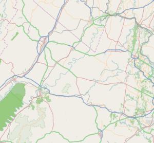
According to the U.S. Census Bureau, the county has a total area of 178 square miles (460 km2), of which 176 square miles (460 km2) is land and 2.2 square miles (5.7 km2) (1.2%) is water.[4] It is the third-smallest county in Virginia by total area.
Adjacent counties
- Loudoun County, Virginia – East
- Warren County, Virginia – Southwest
- Fauquier County, Virginia – Southeast
- Frederick County, Virginia – West
- Jefferson County, West Virginia – North
Government
Board of Supervisors
- Berryville District: Mary Costello Daniel (D)
- Buckmarsh District: David Weiss (R)
- Millwood District: Terri Catlett (I)
- Russell District: Barbara Byrd (I)
- White Post District: Bev McKay (R)
Constitutional officers
- Clerk of the Circuit Court: Helen Butts (D)
- Commissioner of the Revenue: Donna Mathews Peake (R)
- Commonwealth's Attorney: Anne M. Williams (R)
- Sheriff: Anthony W. Roper (D)
- Treasurer: Sharon E. Keeler (D)
Clarke County is represented by Republican Jill Holtzman Vogel in the Virginia Senate, Republican Dave LaRock and Democrat Wendy Gooditis in the Virginia House of Delegates, and Democrat Jennifer Wexton in the U.S. House of Representatives.
| Year | Republican | Democratic | Third parties |
|---|---|---|---|
| 2016 | 56.8% 4,661 | 37.2% 3,051 | 6.1% 501 |
| 2012 | 55.4% 4,296 | 41.7% 3,239 | 2.9% 227 |
| 2008 | 51.7% 3,840 | 46.5% 3,457 | 1.8% 134 |
| 2004 | 57.5% 3,741 | 41.5% 2,699 | 1.0% 65 |
| 2000 | 54.6% 2,883 | 41.0% 2,166 | 4.5% 235 |
| 1996 | 48.2% 2,201 | 41.7% 1,906 | 10.1% 462 |
| 1992 | 42.9% 1,994 | 39.0% 1,811 | 18.1% 843 |
| 1988 | 62.2% 2,502 | 36.8% 1,478 | 1.0% 40 |
| 1984 | 67.2% 2,529 | 32.3% 1,215 | 0.5% 19 |
| 1980 | 57.4% 1,876 | 35.4% 1,156 | 7.2% 234 |
| 1976 | 51.5% 1,440 | 45.7% 1,276 | 2.8% 78 |
| 1972 | 69.1% 1,816 | 27.2% 715 | 3.7% 96 |
| 1968 | 42.6% 1,127 | 29.1% 768 | 28.3% 749 |
| 1964 | 48.4% 1,068 | 51.5% 1,136 | 0.1% 2 |
| 1960 | 46.3% 804 | 53.2% 923 | 0.5% 9 |
| 1956 | 48.9% 785 | 45.2% 725 | 5.9% 95 |
| 1952 | 52.9% 809 | 46.8% 716 | 0.3% 5 |
| 1948 | 33.2% 384 | 41.6% 482 | 25.2% 292 |
| 1944 | 33.6% 415 | 66.0% 816 | 0.4% 5 |
| 1940 | 24.1% 333 | 75.6% 1,043 | 0.3% 4 |
| 1936 | 17.4% 198 | 82.4% 940 | 0.3% 3 |
| 1932 | 12.7% 124 | 86.4% 841 | 0.8% 8 |
| 1928 | 25.1% 248 | 74.9% 740 | |
| 1924 | 9.8% 76 | 88.2% 687 | 2.1% 16 |
| 1920 | 15.8% 154 | 79.3% 774 | 4.9% 48 |
| 1916 | 7.7% 49 | 92.2% 590 | 0.2% 1 |
| 1912 | 6.2% 39 | 91.4% 576 | 2.4% 15 |
Demographics
| Historical population | |||
|---|---|---|---|
| Census | Pop. | %± | |
| 1840 | 6,353 | — | |
| 1850 | 7,352 | 15.7% | |
| 1860 | 7,146 | −2.8% | |
| 1870 | 6,670 | −6.7% | |
| 1880 | 7,682 | 15.2% | |
| 1890 | 8,071 | 5.1% | |
| 1900 | 7,927 | −1.8% | |
| 1910 | 7,468 | −5.8% | |
| 1920 | 7,165 | −4.1% | |
| 1930 | 7,167 | 0.0% | |
| 1940 | 7,159 | −0.1% | |
| 1950 | 7,074 | −1.2% | |
| 1960 | 7,942 | 12.3% | |
| 1970 | 8,102 | 2.0% | |
| 1980 | 9,965 | 23.0% | |
| 1990 | 12,101 | 21.4% | |
| 2000 | 12,652 | 4.6% | |
| 2010 | 14,034 | 10.9% | |
| Est. 2018 | 14,523 | [6] | 3.5% |
| U.S. Decennial Census[7] 1790–1960[8] 1900–1990[9] 1990–2000[10] | |||
As of the census[11] of 2000, there were 12,652 people, 4,942 households, and 3,513 families residing in the county. The population density was 72 people per square mile (28/km2). There were 5,388 housing units at an average density of 30 per square mile (12/km2). The racial makeup of the county was 91.15% White, 6.73% Black or African American, 0.19% Native American, 0.49% Asian, 0.03% Pacific Islander, 0.55% from other races, and 0.85% from two or more races. 1.46% of the population was Hispanic or Latino of any race.
By 2005 90.1% of Clarke County's population was non-Hispanic whites. 6.3% were African-American. 0.2% Native American. 0.6% Asian. 2.6% were Latino.
There were 4,942 households, out of which 29.40% had children under the age of 18 living with them, 58.20% were married couples living together, 8.90% had a female householder with no husband present, and 28.90% were non-families. 24.10% of all households were made up of individuals, and 9.90% had someone living alone who was 65 years of age or older. The average household size was 2.50 and the average family size was 2.97.
In the county, the population was spread out, with 23.40% under the age of 18, 5.80% from 18 to 24, 29.10% from 25 to 44, 27.10% from 45 to 64, and 14.60% who were 65 years of age or older. The median age was 41 years. For every 100 females, there were 98.00 males. For every 100 females age 18 and over, there were 96.60 males.
The median income for a household in the county was $51,601, and the median income for a family was $59,750. Males had a median income of $40,254 versus $30,165 for females. The per capita income for the county was $24,844. About 4.20% of families and 6.60% of the population were below the poverty line, including 7.10% of those under age 18 and 11.10% of those age 65 or over.
Transportation
Major highways
The Norfolk Southern Railway's H-Line runs the perimeter of Clarke County.
Service
Communities
Towns
Census-designated place
Other unincorporated communities
Gallery
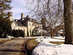 Fairfield Estate (1765)
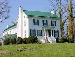 Soldier's Rest (1769)
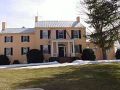 Norwood Estate (1780)
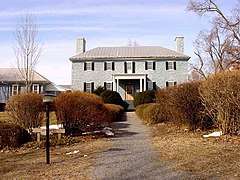 Holy Cross Abbey (1784)
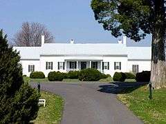 Audley Estate (1794)
 Bel Voi (1803)
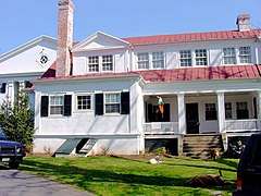 Rosemont Estate (1811)
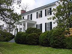 Clay Hill (1816)
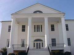 Clifton (1833)
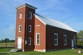 Stone's Chapel (1848)
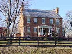 Glendale Farm (1850)
References
- "State & County QuickFacts". United States Census Bureau. Retrieved January 1, 2014.
- "Find a County". National Association of Counties. Archived from the original on 2011-05-31. Retrieved 2011-06-07.
- "History of Bank of Clarke County". Archived from the original on 3 February 2017. Retrieved 10 March 2017.
- "US Gazetteer files: 2010, 2000, and 1990". United States Census Bureau. 2011-02-12. Retrieved 2011-04-23.
- Leip, David. "Dave Leip's Atlas of U.S. Presidential Elections". uselectionatlas.org. Archived from the original on 23 March 2018. Retrieved 7 May 2018.
- "Population and Housing Unit Estimates". Retrieved July 14, 2019.
- "U.S. Decennial Census". United States Census Bureau. Retrieved January 1, 2014.
- "Historical Census Browser". University of Virginia Library. Archived from the original on December 26, 2013. Retrieved January 1, 2014.
- "Population of Counties by Decennial Census: 1900 to 1990". United States Census Bureau. Archived from the original on December 15, 2013. Retrieved January 1, 2014.
- "Census 2000 PHC-T-4. Ranking Tables for Counties: 1990 and 2000" (PDF). United States Census Bureau. Archived (PDF) from the original on December 18, 2014. Retrieved January 1, 2014.
- "U.S. Census website". United States Census Bureau. Retrieved 2011-05-14.
External links
| Wikimedia Commons has media related to Clarke County, Virginia. |
- Clarke County Official Government Website
- Clarke County Public Schools
- Clarke County Historical Association
- VAGenWeb Clarke County
- Clarke County Fair
- Clarke County at the Wayback Machine (archived May 20, 2000)
Places adjacent to Clarke County, Virginia | ||||||||||
|---|---|---|---|---|---|---|---|---|---|---|
| ||||||||||
Municipalities and communities of Clarke County, Virginia, United States | ||
|---|---|---|
| Towns | Map of Virginia highlighting Clarke County | |
| CDPs | ||
| Unincorporated communities | ||
| Footnotes | ‡This populated place also has portions in an adjacent county or counties | |
| Principal cities (and city-like entities) |
|   | |||||||
|---|---|---|---|---|---|---|---|---|---|
| Counties (and county equivalents) |
| ||||||||
The District of Columbia itself, and Virginia's incorporated cities, are county equivalents. Virginia's incorporated cities are listed under their surrounding county. The incorporated cities bordering more than one county (Alexandria, Falls Church and Fredericksburg) are listed under the county they were part of before incorporation as a city. Some unincorporated areas and census-designated places like Silver Spring and Bethesda in Maryland, Reston in Virginia, as well as the County of Arlington in Virginia are also treated as city-like entities (or principal cities) even though they have not been legally incorporated as such. | |||||||||
| Authority control |
|
|---|