Middlesex County, New Jersey
Middlesex County is a county located in north-central New Jersey, United States. In 2019, the Census Bureau estimated the county's population at 825,062, making it the state's second-most populous county,[3][4][5] an increase of 4.1% from 809,858 in the 2010 census.[6][7][8] Middlesex is part of the New York metropolitan area, and its county seat is New Brunswick.[2] The center of population of the state of New Jersey is located in Middlesex County, in East Brunswick Township, just east of the New Jersey Turnpike.[9] The 2000 Census showed that the county ranked 63rd in the United States among the wealthiest counties by median household income.[10] The Bureau of Economic Analysis ranked the county as having the 143rd-highest per capita income of all 3,113 counties in the United States (and the 10th-highest in New Jersey) as of 2009.[11] Middlesex County holds the nickname, The Greatest County in the Land.[1]
Middlesex County | |
|---|---|
 | |
 Seal | |
| Nickname(s): The Greatest County in the Land[1] | |
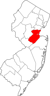 Location within the U.S. state of New Jersey | |
 New Jersey's location within the U.S. | |
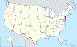
| Coordinates: 40.44°N 74.41°W | |
| Country | |
| State | |
| Founded | 1683 |
| Named for | Historic English county of Middlesex |
| Seat | New Brunswick[2] |
| Largest city | Edison (population) Monroe Township (area) |
| Government | |
| • Freeholder director | Ronald G. Rios (D, term ends December 31, 2017) |
| Area | |
| • Total | 322.83 sq mi (836.1 km2) |
| • Land | 308.91 sq mi (800.1 km2) |
| • Water | 13.91 sq mi (36.0 km2) 4.31% |
| Population (2010) | |
| • Total | 809,858 |
| • Estimate (2019) | 825,062 |
| • Density | 2,500/sq mi (970/km2) |
| Congressional districts | 6th, 12th |
| Website | www |
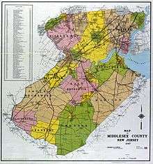
The county was primarily settled due to its ideal location near the Raritan River[12] and was established as of March 7, 1683, as part of the Province of East Jersey and was partitioned as of October 31, 1693, into the townships of Piscataway, Perth Amboy, and Woodbridge. Somerset County was established on May 14, 1688, from portions of Middlesex County.[13] The county's first court met in June 1683 in Piscataway, and held session at alternating sites over the next century in Perth Amboy, Piscataway, and Woodbridge before relocating permanently to New Brunswick in 1778.[14] Middlesex County hosts an extensive park system totaling more than 6,300 acres (2,500 ha).[15]
Geography
According to the 2010 Census, the county had a total area of 322.83 square miles (836.1 km2), including 308.91 square miles (800.1 km2) of land (95.7%) and 13.91 square miles (36.0 km2) of water (4.3%).[16] The county is named after the historic English county of Middlesex.[17]
Bisected by the Raritan River, the county is topographically typical of Central Jersey in that it is largely flat. The elevation ranges from sea level to 300 feet (91 m) above sea level on a hill scaled by Major Road/ Sand Hill Road near Route 1 in South Brunswick Township.[18]
Adjacent counties
- Somerset County – northwest
- Union County – north
- Richmond County, New York – northeast
- Monmouth County – southeast
- Mercer County – southwest
Demographics
| Historical population | |||
|---|---|---|---|
| Census | Pop. | %± | |
| 1790 | 15,956 | — | |
| 1800 | 17,890 | 12.1% | |
| 1810 | 20,381 | 13.9% | |
| 1820 | 21,470 | 5.3% | |
| 1830 | 23,157 | 7.9% | |
| 1840 | 21,893 | * | −5.5% |
| 1850 | 28,635 | 30.8% | |
| 1860 | 34,812 | 21.6% | |
| 1870 | 45,029 | 29.3% | |
| 1880 | 52,286 | 16.1% | |
| 1890 | 61,754 | 18.1% | |
| 1900 | 79,762 | 29.2% | |
| 1910 | 114,426 | 43.5% | |
| 1920 | 162,334 | 41.9% | |
| 1930 | 212,208 | 30.7% | |
| 1940 | 217,077 | 2.3% | |
| 1950 | 264,872 | 22.0% | |
| 1960 | 433,856 | 63.8% | |
| 1970 | 583,813 | 34.6% | |
| 1980 | 595,893 | 2.1% | |
| 1990 | 671,780 | 12.7% | |
| 2000 | 750,162 | 11.7% | |
| 2010 | 809,858 | 8.0% | |
| Est. 2019 | 825,062 | [19] | 1.9% |
| Historical sources: 1790-1990[20] 1970-2010[8] 2000[21] 2010-2019[6][22] * = Lost territory in previous decade.[13] | |||
Middlesex County, is prominently known for its significant concentration of Asian Indians. The growing Little India is a South Asian-focused commercial strip in Middlesex County, the U.S. county with the highest concentration of Asian Indians.[23][24][25] The Oak Tree Road strip runs for about one-and-a-half miles through Edison and neighboring Iselin in Woodbridge Township, near the area's sprawling Chinatown and Koreatown, running along New Jersey Route 27.[26] It is the largest and most diverse South Asian cultural hub in the United States.[27][28] Monroe Township in Middlesex County has experienced a particularly rapid growth rate in its Indian American population, with an estimated 5,943 (13.6%) as of 2017,[29] which was 23 times the 256 (0.9%) counted as of the 2000 Census; and Diwali is celebrated by the township as a Hindu holiday. Carteret's Punjabi Sikh community, variously estimated at upwards of 3,000, is the largest concentration of Sikhs in New Jersey.[30] In Middlesex County, election ballots are printed in English, Spanish, Gujarati, Hindi, and Punjabi.[31]
As of 2017 Census estimates, there were 201,243 people of Asian descent in Middlesex County accounting for 24% of the county's total population.[32] At 61.57% of the population of Asian descent, Indian Americans accounted for 12.93% (104,705 people) of the county's total population in 2010, increasing to 127,875 (15.3%, the highest of any U.S. county) by 2017, more than that of the other Asian sub-groups combined.[32][33]
Census 2010
The 2010 United States Census counted 809,858 people, 281,186 households, and 203,016.292 families in the county. The population density was 2,621.6 per square mile (1,012.2/km2). There were 294,800 housing units at an average density of 954.3 per square mile (368.5/km2). The racial makeup was 58.60% (474,589) White, 9.69% (78,462) Black or African American, 0.34% (2,777) Native American, 21.40% (173,293) Asian, 0.03% (251) Pacific Islander, 6.99% (56,569) from other races, and 2.95% (23,917) from two or more races. Hispanic or Latino of any race were 18.40% (148,975) of the population.[6]
Of the 281,186 households, 34.4% had children under the age of 18; 55.9% were married couples living together; 11.8% had a female householder with no husband present and 27.8% were non-families. Of all households, 22.5% were made up of individuals and 8.9% had someone living alone who was 65 years of age or older. The average household size was 2.8 and the average family size was 3.29.[6]
22.9% of the population were under the age of 18, 10.2% from 18 to 24, 28.3% from 25 to 44, 26.3% from 45 to 64, and 12.3% who were 65 years of age or older. The median age was 37.2 years. For every 100 females, the population had 96.4 males. For every 100 females ages 18 and older there were 94 males.[6]
Census 2000
As of the 2000 United States Census[34] there were 750,162 people, 265,815 households, and 190,855 families residing in the county. The population density was 2,422 people per square mile (935/km²). There were 273,637 housing units at an average density of 884 per square mile (341/km²). The racial makeup of the county was 68.42% White, 9.13% Black or African American, 0.20% Native American, 13.89% Asian, 0.04% Pacific Islander, 5.71% from other races, and 2.60% from two or more races. 13.59% of the population were Hispanic or Latino of any race.[21][35] Among residents listing their ancestry, 16.1% were of Italian, 13.8% Irish, 10.2% German and 9.8% Polish ancestry according to the 2000 Census.[35] [36]
There were 265,815 households out of which 34.20% had children under the age of 18 living with them, 57.00% were married couples living together, 10.80% had a female householder with no husband present, and 28.20% were non-families. 22.40% of all households were made up of individuals and 8.70% had someone living alone who was 65 years of age or older. The average household size was 2.74 and the average family size was 3.23.[21]
In the county, the population was spread out with 23.70% under the age of 18, 9.50% from 18 to 24, 32.80% from 25 to 44, 21.70% from 45 to 64, and 12.30% who were 65 years of age or older. The median age was 36 years. For every 100 females, there were 96.40 males. For every 100 females age 18 and over, there were 93.50 males.[21]
The median income for a household in the county was $61,446, and the median income for a family was $70,749. Males had a median income of $49,683 versus $35,054 for females. The per capita income for the county was $26,535. About 4.2% of families and 6.6% of the population were below the poverty line, including 7.2% of those under age 18 and 6.0% of those age 65 or over.[35][37]
Government
Middlesex County is governed by a Board of Chosen Freeholders, whose seven members are elected at-large on a partisan basis to serve three-year terms of office on a staggered basis, with either two or three seats coming up for election each year as part of the November general election. At an annual reorganization meeting held in January, the board selects from among its members a Freeholder Director and Deputy Director. The Freeholder Director appoints Freeholders to serve as Chairpersons and members on the various committees which oversee county departments.[38] Middlesex County also elects three "constitutional officers" whose existence is laid out in the New Jersey Constitution. The County Clerk and Surrogate serve five-year terms and the Sheriff serves a three-year term of office.[39][40][41] In 2016, freeholders were paid $23,438 and the freeholder director was paid an annual salary of $24,428, though Ronald Rios has accepted a salary of $8,340 as director.[42]
As of 2017, Middlesex County's Freeholders (with party affiliation, term-end year and residence listed in parentheses) are:[38] [43]
- Freeholder Director Ronald G. Rios (D, term as freeholder ends December 31, 2018; term as freeholder director ends 2018; Carteret)[44]
- Freeholder Deputy Director Charles E. Tomaro (D, term as freeholder and as deputy director ends 2017; Edison)[45]
- Kenneth Armwood (D, 2019; Piscataway)[46]
- Charles Kenny (D, 2019; Woodbridge Township)[47]
- Leslie Koppel (D, 2017 - appointed to serve an unexpired term; Monroe Township)[48]
- Shanti Narra (D, 2018 - appointed to serve an unexpired term; North Brunswick)[49]
- Blanquita B. Valenti (D, 2019; New Brunswick)[50]
Article VII Section II of the New Jersey State Constitution requires each county in New Jersey have three elected administrative officials known as "constitutional officers." These officers are the County Clerk and County Surrogate (both elected for five-year terms of office) and the County Sheriff (elected for a three-year term).[51] Middlesex county's constitutional officers are:[43]
- County Clerk Elaine M. Flynn (D, 2020; Old Bridge Township)[52][53]
- Sheriff Mildred S. Scott (D, 2019; Piscataway)[54][55]
- Surrogate Kevin J. Hoagland (D, 2017; New Brunswick)[56][57]
The Middlesex County Prosecutor is Chris Kubereit who was sworn in as acting County Prosecutor in September 2019, replacing Andrew C. Carey of Monroe Township.[58][59]
Middlesex County constitutes Vicinage 8 of the New Jersey Superior Court; the vicinage is seated at the Middlesex County Courthouse, at 56 Paterson Street in New Brunswick.[60] The Middlesex Vicinage also has facilities for the Family Part at the Middlesex County Family Courthouse at 120 New Street, also in New Brunswick; there are also other facilities in New Brunswick and Perth Amboy for Probation.[60] The Assignment Judge for Vicinage 8 is Alberto Rivas.[60]
The 6th and 12th Congressional Districts cover the county.[61][62] For the 116th United States Congress, New Jersey's Sixth Congressional District is represented by Frank Pallone (D, Long Branch).[63][64] For the 116th United States Congress, New Jersey's Twelfth Congressional District is represented by Bonnie Watson Coleman (D, Ewing Township).[65][66]
The county is part of the 12th, 14th, 16th, 17th, 18th, 19th and 22nd Districts in the New Jersey Legislature.[67] For the 2018–2019 session (Senate, General Assembly), the 12th Legislative District of the New Jersey Legislature is represented in the State Senate by Samuel D. Thompson (R, Old Bridge Township) and in the General Assembly by Robert D. Clifton (R, Matawan) and Ronald S. Dancer (R, Plumsted Township).[68][69] For the 2018–2019 session (Senate, General Assembly), the 14th Legislative District of the New Jersey Legislature is represented in the State Senate by Linda R. Greenstein (D, Plainsboro Township) and in the General Assembly by Daniel R. Benson (D, Hamilton Township, Mercer County) and Wayne DeAngelo (D, Hamilton Township, Mercer County).[70][71] For the 2018–2019 session (Senate, General Assembly), the 16th Legislative District of the New Jersey Legislature is represented in the State Senate by Christopher Bateman (R, Branchburg) and in the General Assembly by Andrew Zwicker (D, South Brunswick) and Roy Freiman (D, Hillsborough Township).[72][73] For the 2018–2019 session (Senate, General Assembly), the 17th Legislative District of the New Jersey Legislature is represented in the State Senate by Bob Smith (D, Piscataway) and in the General Assembly by Joseph Danielsen (D, Franklin Township, Somerset County) and Joseph V. Egan (D, New Brunswick).[74][75] For the 2018–2019 session (Senate, General Assembly), the 18th Legislative District of the New Jersey Legislature is represented in the State Senate by Patrick J. Diegnan (D, South Plainfield) and in the General Assembly by Robert Karabinchak (D, Edison) and Nancy Pinkin (D, East Brunswick).[76][77] For the 2018–2019 session (Senate, General Assembly), the 19th Legislative District of the New Jersey Legislature is represented in the State Senate by Joe Vitale (D, Woodbridge Township) and in the General Assembly by Craig Coughlin (D, Woodbridge Township) and Yvonne Lopez (D, Perth Amboy).[78][79] For the 2018–2019 session (Senate, General Assembly), the 22nd Legislative District of the New Jersey Legislature is represented in the State Senate by Nicholas Scutari (D, Linden) and in the General Assembly by Linda Carter (politician) (D, Plainfield) and James J. Kennedy (D, Rahway).[80][81] Carter was appointed in May 2018 to fill the vacant seat left following the death of Jerry Green the previous month after 26 years of service.[82]
Politics
As of March 23, 2011, there were a total of 455,044 registered voters in Middlesex County, of which 169,718 (37.3%) were registered as Democrats, 57,711 (12.7%) were registered as Republicans and 227,355 (50.0%) were registered as Unaffiliated. There were 260 voters registered to other parties.[83]
After being a Republican stronghold in the late 19th and early 20th centuries, Middlesex County leaned Democratic for much of the 20th century beginning with Franklin Roosevelt's victory in the county in 1932. Throughout the twentieth century, in close elections the county would always vote Democratic, sometimes by solid margins, but the county was willing to flip Republican in the midst of nationwide Republican landslides in the 1970s and 80s. However, since the 1990s, Middlesex County has become a Democratic stronghold at the national level, mirroring the state's heavy swing to the Democrats.
Democrat Bill Clinton carried the county in 1992 and it has remained reliably blue in every election since. In the nationally close 2000 election, Democrat Al Gore won the county decisively with 59.9% of the vote to Republican George W. Bush's 36.1%, a Democratic victory margin of 23.7%, while winning the state overall by a 56-40 margin. In the 2004 U.S. presidential election, many of the suburban counties surrounding New York City, including Middlesex County, swung Republican in response to the 9/11 terrorist attacks, but Democrat John Kerry still carried the county comfortably by a 13.6% margin over George W. Bush, Kerry taking 56.3% of the vote to Bush's 42.8%, while Kerry carried the state overall by 6.7% over Bush.[84] In 2008, Barack Obama carried Middlesex County by a much larger 21.8% margin over John McCain, Obama taking 60.2% of the vote to McCain's 38.4%, while Obama won New Jersey overall by 15.5% over McCain.[85] In 2012, Obama won an even more commanding victory in the county, receiving 63.2% of the vote to Republican Mitt Romney's 35.6%, a Democratic victory margin of 27.6%, while carrying New Jersey overall by 17.8%.[86] Like much of the New York City metro area, Middlesex County was one of the few parts of the country to actually swing even harder in Obama's favor in 2012 compared to 2008, even as he lost ground nationally, indicating a long-term trend toward Democratic dominance in Middlesex County.
In the 2005 Gubernatorial Election, the county went to Democrat Jon Corzine by a 56-39 margin; while in the 2009 Gubernatorial Election, Republican Chris Christie received 47% of the vote, defeating incumbent Democrat Corzine, who received around 45%.
| Year | Republican | Democratic | Third parties |
|---|---|---|---|
| 2016 | 37.4% 122,953 | 58.8% 193,044 | 3.8% 12,560 |
| 2012 | 35.6% 107,310 | 63.1% 190,555 | 1.3% 3,995 |
| 2008 | 38.4% 123,695 | 60.2% 193,812 | 1.4% 4,367 |
| 2004 | 42.8% 126,492 | 56.3% 166,628 | 0.9% 2,685 |
| 2000 | 36.1% 93,545 | 59.9% 154,998 | 4.0% 10,306 |
| 1996 | 31.9% 82,433 | 56.2% 145,201 | 11.9% 30,752 |
| 1992 | 38.1% 108,701 | 45.2% 128,824 | 16.7% 47,746 |
| 1988 | 54.3% 143,422 | 44.4% 117,149 | 1.3% 3,548 |
| 1984 | 59.8% 160,221 | 39.2% 104,905 | 1.0% 2,727 |
| 1980 | 50.7% 122,354 | 40.3% 97,304 | 8.9% 21,548 |
| 1976 | 47.1% 113,539 | 51.0% 122,859 | 1.9% 4,466 |
| 1972 | 61.4% 149,033 | 36.4% 88,397 | 2.2% 5,264 |
| 1968 | 42.8% 96,515 | 45.8% 103,339 | 11.4% 25,676 |
| 1964 | 29.4% 63,370 | 70.1% 151,196 | 0.5% 1,052 |
| 1960 | 41.6% 83,025 | 58.2% 116,095 | 0.2% 436 |
| 1956 | 60.5% 100,071 | 39.1% 64,538 | 0.4% 677 |
| 1952 | 50.3% 73,577 | 48.0% 70,234 | 1.7% 2,413 |
| 1948 | 42.9% 49,810 | 53.0% 61,634 | 4.1% 4,766 |
| 1944 | 42.1% 45,232 | 56.4% 60,504 | 1.5% 1,642 |
| 1940 | 38.3% 41,709 | 61.6% 67,140 | 0.2% 164 |
| 1936 | 34.6% 32,959 | 64.7% 61,679 | 0.7% 702 |
| 1932 | 40.5% 32,673 | 56.9% 45,997 | 2.6% 2,111 |
| 1928 | 52.4% 38,714 | 47.2% 34,908 | 0.4% 328 |
| 1924 | 62.3% 34,556 | 29.5% 16,373 | 8.2% 4,553 |
| 1920 | 69.7% 29,334 | 27.6% 11,618 | 2.7% 1,136 |
| 1916 | 53.5% 11,851 | 45.0% 9,975 | 1.4% 320 |
| 1912 | 25.8% 4,743 | 44.5% 8,186 | 29.7% 5,470 |
| 1908 | 57.5% 11,270 | 40.7% 7,966 | 1.8% 359 |
| 1904 | 57.2% 10,117 | 39.6% 6,996 | 3.2% 569 |
| 1900 | 55.2% 9,347 | 42.5% 7,191 | 2.4% 399 |
| County CPVI: D+11 | |||
Sheriffs
Thomas N. Acken served as the sheriff in 1891. Joseph Spicuzzo served in 2014 and was arrested for bribery.[88] Mildred S. Scott is the current sheriff.
Transportation
Middlesex County hosts various county roads, state routes, US routes, and interstate highways, as well as toll highways. As of May 2010, the county had a total of 2,584.38 miles (4,159.16 km) of roadways, of which 2,118.08 miles (3,408.72 km) were maintained by the municipality, 292.16 miles (470.19 km) by Middlesex County and 131.48 miles (211.60 km) by the New Jersey Department of Transportation and 42.66 miles (68.65 km) by the New Jersey Turnpike Authority.[89]
County roads include County Route 501, County Route 514, County Route 516 (only in Old Bridge), County Route 520, County Route 522, County Route 527, County Route 529, County Route 531, County Route 535 and County Route 539.
The state routes are: Route 18, Route 26 (only in North Brunswick Township – entirely concurrent with Livingston Avenue), Route 27, Route 28, Route 32, Route 33 (only in Monroe Township), Route 34 (only in Old Bridge), Route 35, Route 91 (concurrent with Jersey Avenue in North Brunswick Township and entering New Brunswick), Route 171, Route 172 (only in New Brunswick), Route 184 and Route 440.
U.S. Routes include: U.S. Route 1, U.S. Route 9, U.S. Route 1/9 (only in Woodbridge Township) and U.S. Route 130.
The county also includes some limited access highways and Interstates as well. Middlesex County hosts the southern end of the Middlesex Freeway (Interstate 287) which then turns into Route 440 that connects to the Outerbridge Crossing. The Garden State Parkway passes through the eastern edge of the county, which features nine interchanges and the northern start/end of the split-roadways (Express & Local Lanes). The New Jersey Turnpike carries Interstate 95 through the center of the county. The Turnpike has five interchanges in Middlesex County: Exit 12 in Carteret, Exit 11 in Woodbridge Township, Exit 10 in Edison, Exit 9 in East Brunswick and Exit 8A in Monroe Township.[90]
The NJDOT is upgrading the Route 18 "avenue" to a freeway between the Route 1 interchange all the way up to the new 18 Extension in Piscataway Township.[91]
The Turnpike Authority planned to build Route 92, which was to start near the intersection of Ridge Road & Route 1 in South Brunswick Township to Interchange 8A in Monroe Township. This plan was cancelled on December 1, 2006.
The southern end of the "dual-dual" configuration (inner car lanes and outer truck lanes) used to be one mile south of Interchange 8A at the border of Cranbury Township and Monroe Township. It was relocated to Exit 6 in Mansfield Township in Burlington County after the Turnpike widening project was completed in early November 2014.[92]
Public transportation
NJ Transit provides Middlesex County with frequent commuter rail service along the North Jersey Coast Line,[93] Northeast Corridor Line,[94] and Raritan Valley Line.[95] The North Jersey Coast Line runs through the eastern part of the county. The Northeast Corridor Line runs through the northern and central part of the county. The Raritan Valley Line serves Dunellen and is accessible to other communities along the county's northern border with Union and Somerset counties.
Intercity rail service is provided by Amtrak. The routes that run through Middlesex County are the Acela Express, Keystone, Northeast Regional, and Vermonter services, although only the Keystone and Northeast Regional have regular stops within Middlesex County, at either New Brunswick or Metropark station. The Acela service also occasionally stops at Metropark.
Bus service in Middlesex County is provided by New Jersey Transit, Coach USA's Suburban Transit, the extensive Rutgers Campus bus network,[96] the MCAT shuttle system,[97] and DASH buses.[98] There are bus routes that serve all townships in the county on weekdays,[99] and studies are being conducted to create the New Brunswick Bus Rapid Transit system.
Higher education
- Middlesex County College (Edison - main campus; New Brunswick, Perth Amboy)[100]
- Rutgers University New Brunswick Campus (New Brunswick, Piscataway)[101]
- Rutgers Biomedical and Health Sciences (New Brunswick)[102]
- Princeton University – Forrestal Campus (Plainsboro)[103]
- DeVry University (North Brunswick)[104]
- Chamberlain University (North Brunswick)
- New Brunswick Theological Seminary (New Brunswick Campus)[105]
Healthcare
The county offers more than 1,900 inpatient beds among five major hospitals.[106][107]
| Hospital | Town | Type | Beds | Health Network |
|---|---|---|---|---|
| JFK Medical Center | Edison | Acute | 498[108] | Hackensack Meridian Health |
| PSE&G Children's Specialized Hospital | New Brunswick | Pediatric Rehabiltation | 140[109] | RWJBarnabas Health |
| Raritan Bay Medical Center (Old Bridge) | Old Bridge | Acute | 113[110] | Hackensack Meridian Health |
| Raritan Bay Medical Center (Perth Amboy) | Perth Amboy | Acute | 388[110] | Hackensack Meridian Health |
| Robert Wood Johnson University Hospital | New Brunswick | Major Teaching | 465[111] | RWJBarnabas Health |
| The Bristol-Myers Squibb Children's Hospital | New Brunswick | Acute Pediatric | 105[112] | RWJBarnabas Health |
| Rutgers Cancer Institute of New Jersey | New Brunswick | Research, Cancer | RWJBarnabas Health | |
| St. Peter's University Hospital | New Brunswick | Acute Teaching | 478[113] | Saint Peters HCS |
| Penn Medicine Princeton Medical Center | Plainsboro | Acute Teaching | 305[114] | Penn Medicine |
Major employers
Major non-governmental employers in Middlesex County include the following, grouped by ranges of employees:[115][116]
- 9,010: Rutgers University
- 5,000 – 5,249: Robert Wood Johnson University Hospital
- 3,500 – 3,749: Bristol-Myers Squibb, Wakefern Food Corporation
- 3,000 – 3,249: Merrill Lynch & Company, Novo Nordisk
- 2,750 – 2,999: Johnson & Johnson, Prudential Insurance Company, Silverline Building Products, St. Peter's University Hospital, Telcordia Technologies
- 2,500 – 2,749: JFK Medical Center, Raritan Bay Medical Center
- 2,000 – 2,249: Pathmark
- 1,750 – 1,999: Home Depot, United Parcel Service
- 1,500 – 1,749: Amerada Hess Corporation, Dow Jones & Company, Siemens AG
- 1,250 – 1,499: AT&T, BASF (formerly Engelhard)
- 1,000 – 1,249: Aetna, Fujitsu, Prudential
- Undisclosed: Canon, Japanese company specializing in imaging products.
Municipalities
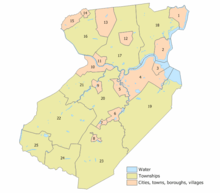
Municipalities in Middlesex County (with 2010 Census data for population, housing units and area in square miles) are:[117] Other, unincorporated communities in the county are listed next to their parent municipality. Many of these areas are census-designated places that have been defined by the United States Census Bureau for enumeration purposes within a Township and for which 2010 population data is included in parentheses.
| Municipality | Map key |
Municipal type |
Population | Housing units |
Total area |
Water area |
Land area |
Pop. density |
Housing density |
Unincorporated communities |
|---|---|---|---|---|---|---|---|---|---|---|
| Carteret | 1 | Borough | 22,844 | 8,148 | 5.00 | 0.58 | 4.42 | 5,171.1 | 1,844.4 | Chrome West Carteret |
| Cranbury | 24 | Township | 3,857 | 1,371 | 13.40 | 0.15 | 13.25 | 291.2 | 103.5 | Cranbury CDP (2,181) Cranbury Station Wyckoffs Mills |
| Dunellen | 14 | Borough | 7,227 | 2,683 | 1.05 | 0.00 | 1.05 | 6,894.8 | 2,559.7 | |
| East Brunswick Township | 20 | Township | 47,512 | 17,367 | 22.27 | 0.57 | 21.70 | 2,189.6 | 800.4 | Brookview Dunhams Corner East Spotswood Fairview Knolls Farrington Lake Heights Gillilandtown Halls Corner Herberts Jamesburg Park Lawrence Brook Manor Newton Heights Orchard Heights Patricks Corner Paulas Corner Tanners Corner Washington Heights Westons Mills |
| Edison Township | 17 | Township | 99,967 | 36,302 | 30.64 | 0.70 | 29.94 | 3,339.0 | 1,212.5 | Bonhamtown Clara Barton Greensand Haven Homes Lahiere Lincoln Park Lindenau Martins Landing Menlo Park New Dover New Durham Nixon North Edison Oak Tree Phoenix Potters Pumptown Raritan Manor Sand Hills Stelton Valentine Washington Park |
| Helmetta | 7 | Borough | 2,178 | 920 | 0.91 | 0.06 | 0.85 | 2,562.9 | 1,082.6 | |
| Highland Park | 11 | Borough | 13,982 | 6,203 | 1.82 | 0.01 | 1.81 | 7,728.1 | 3,428.5 | |
| Jamesburg | 8 | Borough | 5,915 | 2,267 | 0.88 | 0.01 | 0.88 | 6,741.8 | 2,583.9 | |
| Metuchen | 12 | Borough | 13,574 | 5,440 | 2.77 | 0.00 | 2.76 | 4,910.4 | 1,967.9 | Jefferson Park Robinvale |
| Middlesex | 15 | Borough | 13,635 | 5,148 | 3.54 | 0.02 | 3.52 | 3,876.2 | 1,463.5 | |
| Milltown | 9 | Borough | 6,893 | 2,698 | 1.60 | 0.04 | 1.55 | 4,443.0 | 1,739.0 | |
| Monroe Township | 23 | Township | 39,132 | 18,002 | 42.23 | 0.26 | 41.97 | 932.3 | 428.9 | Applegarth Clearbrook Clearbrook Park CDP (2,667) Concordia CDP (3,092) Gravel Hill Half Acre Hoffman Jamesburg Gardens Matchaponix Middlesex Downs Mounts Mills Old Church Outcalt Prospect Plains Rossmoor CDP (2,666) Shore Road Estates Spotswood Manor Texas Tracy Union Valley Whittingham CDP (2,476) Wyckoffs Mills |
| New Brunswick | 10 | City | 55,181 | 15,053 | 5.79 | 0.56 | 5.23 | 10,556.4 | 2,879.7 | Edgebrook Feaster Park Lincoln Park Raritan Gardens Westons Mills |
| North Brunswick Township | 21 | Township | 40,742 | 15,045 | 12.27 | 0.27 | 12.00 | 3,396.2 | 1,254.1 | Adams Berdines Corner Black Horse Franklin Park Georges Road Maple Meade Patricks Corner Red Lion |
| Old Bridge Township | 19 | Township | 65,375 | 24,638 | 40.78 | 2.72 | 38.06 | 1,717.7 | 647.3 | Browntown Brownville CDP (2,383) Brunswick Gardens Cheesequake Cottrell Corners East Spotswood Laurence Harbor CDP (6,536) Madison Park CDP (7,144) Matchaponix Moerls Corner Morristown Old Bridge CDP (23,753) Parlin Redshaw Corner Runyon Sayerwood South South Old Bridge Texas |
| Perth Amboy | 2 | City | 50,814 | 16,556 | 5.96 | 1.26 | 4.70 | 10,806.8 | 3,521.0 | Barber Harbor Terrace John J Delaney Homes Maurer William Dunlap Homes |
| Piscataway Township | 16 | Township | 56,044 | 17,777 | 19.03 | 0.19 | 18.83 | 2,975.5 | 943.8 | Fieldville New Market Newtown North Stelton Possumtown Randolphville Raritan Landing Riverview Manor Society Hill CDP (3,829) |
| Plainsboro Township | 25 | Township | 22,999 | 10,089 | 12.21 | 0.42 | 11.78 | 1,951.6 | 856.1 |
Plainsboro Center CDP (2,712) |
| Sayreville | 4 | Borough | 42,704 | 16,393 | 18.70 | 2.86 | 15.84 | 2,695.7 | 1,034.8 | Crossmans Ernston Gillespie Laurel Park MacArthur Manor Melrose Morgan Morgan Heights Parlin Phoenix Runyon Sayre Woods Sayreville Junction Sayreville Station |
| South Amboy | 3 | City | 8,631 | 3,576 | 2.69 | 1.15 | 1.55 | 5,577.1 | 2,310.7 | Mechanicsville Thomas J Dohany Homes |
| South Brunswick Township | 22 | Township | 43,417 | 15,708 | 41.04 | 0.39 | 40.65 | 1,068.1 | 386.4 | Cottageville Dayton CDP (7,063) Deans Franklin Park Fresh Ponds Heathcote CDP (5,821) Kendall Park CDP (9,339) Kingston CDP (1,222) Little Rocky Hill Monmouth Junction CDP (2,887) Sand Hills South Brunswick Terrace |
| South Plainfield | 13 | Borough | 23,385 | 8,093 | 8.36 | 0.03 | 8.33 | 2,808.5 | 971.9 | Avon Park Samptown |
| South River | 5 | Borough | 16,008 | 5,957 | 2.92 | 0.15 | 2.77 | 5,781.4 | 2,151.4 | Newton Heights |
| Spotswood | 6 | Borough | 8,257 | 3,242 | 2.47 | 0.20 | 2.27 | 3,642.2 | 1,430.1 | Outcalt |
| Woodbridge Township | 18 | Township | 99,585 | 36,124 | 24.51 | 1.29 | 23.21 | 4,290.0 | 1,556.2 | Avenel CDP (17,011) Boynton Beach Colonia CDP (17,795) Edgars Fords CDP (15,187) Hazelton Hopelawn Iselin CDP (18,695) Keasbey Lynn Woodoaks Menlo Park Terrace Port Reading CDP (3,728) Sand Hills Sewaren CDP (2,756) Shore View Woodbridge CDP (19,265) Woodbridge Oaks |
County parks
- Donaldson Park
- Carteret Park
- Carteret Waterfront Park
- Edison Park
- Fords Park
- Johnson Park
- Medwick Park
- Merrill Park
- Raritan Bay Waterfront Park
- Roosevelt Park
- Spring Lake Park
- Thompson Park
- Warren Park
- Old Bridge Waterfront Walkway
- Alvin P. Williams Memorial Park
- Ambrose & Doty's Brooks Park
- Davidson's Mill Pond Park
- Ireland Brook Park
- Jamesburg Park Conservation Area
- John A. Phillips Open Space Preserve
- John A. Phillips Park
- Catherine Von Ohlen Park
Climate and weather
| New Brunswick, New Jersey | ||||||||||||||||||||||||||||||||||||||||||||||||||||||||||||
|---|---|---|---|---|---|---|---|---|---|---|---|---|---|---|---|---|---|---|---|---|---|---|---|---|---|---|---|---|---|---|---|---|---|---|---|---|---|---|---|---|---|---|---|---|---|---|---|---|---|---|---|---|---|---|---|---|---|---|---|---|
| Climate chart (explanation) | ||||||||||||||||||||||||||||||||||||||||||||||||||||||||||||
| ||||||||||||||||||||||||||||||||||||||||||||||||||||||||||||
| ||||||||||||||||||||||||||||||||||||||||||||||||||||||||||||
Middlesex has a hot-summer humid continental climate (Dfa) which borders a humid subtropical climate (Cfa) on Raritan Bay. Average monthly temperatures in downtown New Brunswick range from 30.8 °F in January to 75.6 °F in July, while in South Amboy they range from 31.4 °F in January to 75.9 °F in July.
In recent years, average temperatures in the county seat of New Brunswick have ranged from a low of 22 °F (−6 °C) in January to a high of 86 °F (30 °C) in July, although a record low of −13 °F (−25 °C) was recorded in January 1984 and a record high of 103 °F (39 °C) was recorded in July 1999. Average monthly precipitation ranged from 2.98 inches (76 mm) in February to 5.08 inches (129 mm) in July.[118]
See also
- Little India (Middlesex County, New Jersey)
- National Register of Historic Places listings in Middlesex County, New Jersey
References
- Middlesex County The Greatest County in the Land Archived 2016-10-28 at the Wayback Machine, County of Middlesex, New Jersey. Accessed October 27, 2016.
- New Jersey County Map Archived 2017-03-13 at the Wayback Machine, New Jersey Department of State. Accessed July 10, 2017.
- QuickFacts - Middlesex County, New Jersey; New Jersey; United States Archived 2018-04-02 at the Wayback Machine, United States Census Bureau. Accessed March 24, 2018.
- Archived 2020-02-13 at Archive.today, United States Census Bureau. Accessed March 24, 2018.
- GCT-PEPANNCHG: Estimates of Resident Population Change and Rankings: July 1, 2016 to July 1, 2017 - State -- County / County Equivalent from the 2017 Population Estimates for New Jersey Archived February 13, 2020, at Archive.today, United States Census Bureau. Accessed March 24, 2018.
- DP1 - Profile of General Population and Housing Characteristics: 2010 Demographic Profile Data for Middlesex County, New Jersey, United States Census Bureau. Accessed January 22, 2013.
- NJ Labor Market Views Archived September 20, 2013, at the Wayback Machine, New Jersey Department of Labor and Workforce Development, March 15, 2011. Accessed October 6, 2013.
- New Jersey: 2010 - Population and Housing Unit Counts; 2010 Census of Population and Housing Archived 2013-07-23 at the Wayback Machine, p. 6, CPH-2-32. United States Census Bureau, August 2012. Accessed August 29, 2016.
- Population and Population Centers by State: 2000 Archived 2001-12-12 at the Wayback Machine, United States Census Bureau. Accessed July 5, 2011. (see map of location)
- "Census 2000 Demographic Profiles". Archived from the original on July 15, 2011. Retrieved July 5, 2011.
- 250 Highest Per Capita Personal Incomes of the 3113 Counties in the United States, 2009 Archived 2017-11-20 at the Wayback Machine, Bureau of Economic Analysis. Accessed April 9, 2012.
- History Archived 2016-10-17 at the Wayback Machine, Middlesex County, NJ. Accessed March 24, 2018.
- Snyder, John P. The Story of New Jersey's Civil Boundaries: 1606-1968 Archived 2012-06-05 at the Wayback Machine, Bureau of Geology and Topography; Trenton, New Jersey; 1969. p. 161. Accessed October 1, 2013.
- History of the Grand Jury Archived 2013-10-04 at the Wayback Machine, Middlesex County, New Jersey. Accessed October 1, 2013. "By June 19, 1683, the first County Court was held at Piscataway. It sat alternately in Piscataway and Woodbridge until 1688 when Perth Amboy was added as one of the three alternate sites. In 1778, New Brunswick became the most prime town in the county and at that time the Middlesex County Courts were transferred there."
- "At a Glance - Middlesex County, the Greatest County in the Land!". Archived from the original on November 18, 2016. Retrieved December 3, 2016.
- Census 2010 U.S. Gazetteer Files: New Jersey Counties Archived 2015-05-18 at the Wayback Machine, United States Census Bureau. Accessed May 10, 2015.
- Kane, Joseph Nathan; and Aiken, Charles Curry. The American Counties: Origins of County Names, Dates of Creation, and Population Data, 1950-2000, p. 202. Scarecrow Press, 2005. ISBN 0810850362. Accessed January 22, 2013.
- New Jersey County High Points Archived 2015-05-18 at the Wayback Machine, Peakbagger.com. Accessed October 5, 2013.
- "Population and Housing Unit Estimates". Retrieved March 26, 2020.
- Forstall, Richard L. Population of states and counties of the United States: 1790 to 1990 from the Twenty-one Decennial Censuses, pp. 108-109. United States Census Bureau, March 1996. ISBN 9780934213486. Accessed October 3, 2013.
- DP-1 - Profile of General Demographic Characteristics: 2000; Census 2000 Summary File 1 (SF 1) 100-Percent Data for Middlesex County, New Jersey, United States Census Bureau. Accessed January 22, 2013.
- U.S. Census Bureau Delivers New Jersey's 2010 Census Population Totals Archived February 8, 2011, at the Wayback Machine, United States Census Bureau, February 3, 2011. Accessed February 5, 2011.
- Genovese, Peter (16 November 2012). "Big business in Little India: Commerce flourishes in vibrant ethnic neighborhood". nj.com.
- "Eat Street: Oak Tree Road, Iselin, N.J." SAVEUR.
- Joseph Berger. "A Place Where Indians, Now New Jerseyans, Thrive". The New York Times. Retrieved August 22, 2016.
- Shaftel, David (9 March 2017). "Indo-Chinese Food Is Hard to Find, Except in New Jersey" – via NYTimes.com.
- King, Kate (25 September 2017). "'Little India' Thrives in Central New Jersey" – via www.wsj.com.
- Burke, Monte. "How Indo-Americans Created The Ultimate Neighborhood Bank". Forbes.
- DP05: ACS DEMOGRAPHIC AND HOUSING ESTIMATES from the 2013-2017 American Community Survey 5-Year Estimates for Monroe township, Middlesex County, New Jersey Archived 2020-02-13 at Archive.today, United States Census Bureau. Accessed February 11, 2019.
- Kevin Coyne. "Turbans Make Targets, Some Sikhs Find". The New York Times. Retrieved April 28, 2019.
- "State of New Jersey Department of State". State of New Jersey. Retrieved May 29, 2017.
- "ACS DEMOGRAPHIC AND HOUSING ESTIMATES 2013-2017 American Community Survey 5-Year Estimates". U.S. Census Bureau. Archived from the original on February 13, 2020. Retrieved February 15, 2017.
- Ensslin, John C.; and Sheingold, Dave. "Census: Asian Indians one of the fastest growing groups in North Jersey" Archived 2012-09-30 at the Wayback Machine, The Record (Bergen County), May 29, 2011. Accessed January 22, 2013. "Middlesex County has by far the largest Indian-American population, with about 104,705 people, followed by Hudson County, with 37,236, and Bergen County, with 24,973."
- U.S. Census website , United States Census Bureau. Accessed September 4, 2014.
- Tables DP-1 to DP-4 from Census 2000 for Middlesex County, New Jersey Archived May 9, 2007, at the Wayback Machine, United States Census Bureau. Accessed October 1, 2013.
- DP-2 - Profile of Selected Social Characteristics: 2000 from the Census 2000 Summary File 3 (SF 3) - Sample Data for Middlesex County, New Jersey, United States Census Bureau. Accessed September 30, 2013.
- DP-3 - Profile of Selected Economic Characteristics: 2000 from Census 2000 Summary File 3 (SF 3) - Sample Data for Middlesex County, New Jersey, United States Census Bureau. Accessed September 30, 2013.
- Board of Chosen Freeholders Archived 2017-10-22 at the Wayback Machine, Middlesex County, New Jersey. Accessed October 21, 2017.
- History of the County Clerk's Office Archived 2013-08-26 at the Wayback Machine, Constitutional Officers Association of New Jersey. Accessed October 21, 2017.
- History of the County Sheriff's Office Archived 2013-08-26 at the Wayback Machine, Constitutional Officers Association of New Jersey. Accessed October 21, 2017.
- History of the Surrogate's Court Archived 2013-08-26 at the Wayback Machine, Constitutional Officers Association of New Jersey. Accessed October 21, 2017.
- Gallo Jr., Bill. "Which N.J. county freeholders are paid the most?" Archived 2017-10-26 at the Wayback Machine, NJ.com, March 11, 2016. Accessed October 25, 2017. "Freeholder director: $24,438 (Current Freeholder Director Don Rios has opted to take a salary of only $8,340.); Other freeholders: $23,438"
- Elected County Officials Archived 2015-01-13 at the Wayback Machine, Middlesex County, New Jersey. Accessed October 21, 2017.
- Ronald G. Rios Archived 2017-10-22 at the Wayback Machine, Middlesex County, New Jersey. Accessed October 21, 2017.
- Charles E. Tomaro Archived 2017-10-22 at the Wayback Machine, Middlesex County, New Jersey. Accessed October 21, 2017.
- Kenneth Armwood Archived 2017-10-22 at the Wayback Machine, Middlesex County, New Jersey. Accessed October 21, 2017.
- Charles Kenny Archived 2017-10-21 at the Wayback Machine, Middlesex County, New Jersey. Accessed October 21, 2017.
- Freeholder Leslie Koppel Archived 2017-10-22 at the Wayback Machine, Middlesex County, New Jersey. Accessed October 21, 2017.
- Shanti Narra Archived 2016-12-20 at the Wayback Machine, Middlesex County, New Jersey. Accessed December 6, 2016.
- Blanquita B. Valenti Archived 2017-10-22 at the Wayback Machine, Middlesex County, New Jersey. Accessed October 21, 2017.
- New Jersey State Constitution (1947), Article VII, Section II, Paragraph 2 Archived 2014-11-01 at the Wayback Machine, New Jersey Department of State. Accessed October 26, 2017.
- County Clerk Elaine Flynn Archived 2017-10-21 at the Wayback Machine, Middlesex County, New Jersey. Accessed October 21, 2017.
- Members List: Clerks Archived 2017-10-23 at the Wayback Machine, Constitutional Officers Association of New Jersey. Accessed October 22, 2017.
- Sheriff Mildred S. Scott Archived 2017-10-22 at the Wayback Machine, Middlesex County, New Jersey. Accessed October 21, 2017.
- Members List: Sheriffs Archived 2017-10-23 at the Wayback Machine, Constitutional Officers Association of New Jersey. Accessed October 22, 2017.
- Surrogate Kevin J. Hoagland Archived 2017-10-22 at the Wayback Machine, Middlesex County, New Jersey. Accessed October 21, 2017.
- Members List: Surrogates Archived 2017-10-23 at the Wayback Machine, Constitutional Officers Association of New Jersey. Accessed October 22, 2017.
- The Prosecutor's Office Archived 2017-10-29 at the Wayback Machine, Middlesex County, New Jersey. Accessed October 28, 2017.
- "Governor Chris Christie Files Nominations" Archived 2016-06-21 at the Wayback Machine, Governor of New Jersey Chris Christie, press release dated June 3, 2014. Accessed October 26, 2017. "Prosecutorial Nominations - Nominate for appointment Andrew C. Carey (Monroe Township, Middlesex)"
- Middlesex Vicinage Archived 2017-10-10 at the Wayback Machine, New Jersey Courts. Accessed October 21, 2017.
- 2012 Congressional Districts by County Archived 2012-05-26 at the Wayback Machine, New Jersey Department of State Division of Elections. Accessed October 6, 2013.
- Plan Components Report Archived 2013-12-04 at the Wayback Machine, New Jersey Department of State Division of Elections, December 23, 2011. Accessed October 6, 2013.
- Directory of Representatives: New Jersey, United States House of Representatives. Accessed January 3, 2019.
- Biography, Congressman Frank Pallone Jr. Accessed January 3, 2019. "Frank Pallone, Jr., was born in Long Branch, New Jersey, where he grew up and still resides."
- Directory of Representatives: New Jersey, United States House of Representatives. Accessed January 3, 2019.
- Biography, Congresswoman Bonnie Watson Coleman. Accessed January 3, 2019. "Watson Coleman and her husband William reside in Ewing Township and are blessed to have three sons; William, Troy, and Jared and three grandchildren; William, Kamryn and Ashanee."
- 2011 Legislative Districts by County Archived 2012-05-26 at the Wayback Machine, New Jersey Department of State Division of Elections. Accessed October 6, 2013.
- Legislative Roster 2018-2019 Session, New Jersey Legislature. Accessed January 22, 2018.
- District 12 Legislators, New Jersey Legislature. Accessed January 22, 2018.
- Legislative Roster 2018-2019 Session, New Jersey Legislature. Accessed January 22, 2018.
- District 14 Legislators, New Jersey Legislature. Accessed January 22, 2018.
- Legislative Roster 2018-2019 Session, New Jersey Legislature. Accessed January 22, 2018.
- District 16 Legislators, New Jersey Legislature. Accessed January 22, 2018.
- Legislative Roster 2018-2019 Session, New Jersey Legislature. Accessed January 22, 2018.
- District 17 Legislators, New Jersey Legislature. Accessed January 22, 2018.
- Legislative Roster 2018-2019 Session, New Jersey Legislature. Accessed January 22, 2018.
- District 18 Legislators, New Jersey Legislature. Accessed January 22, 2018.
- Legislative Roster 2018-2019 Session, New Jersey Legislature. Accessed January 22, 2018.
- District 19 Legislators, New Jersey Legislature. Accessed January 22, 2018.
- Legislative Roster 2018-2019 Session, New Jersey Legislature. Accessed January 22, 2018.
- District 22 Legislators, New Jersey Legislature. Accessed January 22, 2018.
- Russell, Suzanne. "Linda Carter sworn into General Assembly, replacing Jerry Green", Courier News, May 24, 2018. Accessed July 3, 2018. "Former Union County Freeholder Linda Carter was sworn into the New Jersey General Assembly on Thursday, representing the 22nd Legislative District communities in Middlesex, Somerset and Union counties.... Carter replaces Assemblyman Jerry Green, 79, of Plainfield, who died April 18. Green served 26 years in the assembly."
- Voter Registration Summary - Middlesex Archived 2013-10-04 at the Wayback Machine, New Jersey Department of State Division of Elections, March 23, 2011. Accessed January 11, 2015.
- New Jersey Presidential Election Returns by County 2004 Archived 2008-09-14 at the Wayback Machine, Eagleton Institute of Politics at Rutgers University. Accessed August 31, 2008.
- U.S. Election Atlas Archived 2010-07-22 at the Wayback Machine
- "New Jersey Division of Elections Official General Election Results" (PDF). Archived from the original (PDF) on 9 May 2013. Retrieved 4 February 2014.
- "Archived copy". Archived from the original on 2018-03-23. Retrieved 2018-03-18.CS1 maint: archived copy as title (link)
- "How A Crooked Former Sheriff Persuaded The State To Let Him Out Of Prison". NJ.com. February 1, 2016. Archived from the original on February 4, 2018. Retrieved 2018-02-03.
- Middlesex County Mileage by Municipality and Jurisdiction Archived 2015-02-10 at the Wayback Machine, New Jersey Department of Transportation, May 2010. Accessed July 24, 2014.
- Travel Map Archived 2017-10-25 at the Wayback Machine, New Jersey Turnpike Authority. Accessed October 24, 2017.
- NJDOT breaks ground on project to completeRoute 18 extension to Interstate 287 in Piscataway; Project is designed to improve mobility and promote economic development in central New Jersey Archived 2012-04-02 at the Wayback Machine, New Jersey Department of Transportation press release, dated February 15, 2012. Accessed October 6, 2013.
- Gov. Christie, NJDOT Commissioner FoxPraise $2.3 Billion NJ Turnpike Infrastructure Investment Project Archived 2014-11-03 at the Wayback Machine, New Jersey Turnpike Authority. Accessed November 3, 2014.
- North Jersey Coast Line Archived 2013-07-23 at the Wayback Machine, NJ Transit. Accessed August 24, 2014.
- Northeast Corridor Line Archived 2014-07-12 at the Wayback Machine, NJ Transit. Accessed August 24, 2014.
- Raritan Valley Line Archived 2013-10-15 at the Wayback Machine, NJ Transit. Accessed August 24, 2014.
- Campus Buses/Shuttle Service, Rutgers University. Accessed November 6, 2019.
- Middlesex County Area Transit (MCAT), Middlesex County. Accessed November 6, 2019.
- DASH Bus Routes Archived 2013-06-15 at the Wayback Machine, Ridewise. Accessed October 9, 2016.
- Middlesex County Transit Guide, Middlesex County. Accessed November 6, 2019.
- Locations Archived 2015-09-05 at the Wayback Machine, Middlesex County College. Accessed September 17, 2015.
- One Community, Five Campuses Archived 2015-09-06 at the Wayback Machine, Rutgers University–New Brunswick. Accessed September 17, 2015.
- Locations and Directions Archived 2015-09-07 at the Wayback Machine, Rutgers Biomedical and Health Sciences. Accessed September 17, 2015.
- Forrestal Campus Archived 2008-07-05 at the Wayback Machine, Princeton University. Accessed July 23, 2008.
- North Brunswick Campus Archived 2015-09-05 at the Wayback Machine, DeVry University. Accessed September 17, 2015.
- Health Care Archived 2015-09-18 at the Wayback Machine, Middlesex County, New Jersey. Accessed September 17, 2015.
- Healthcare in Middlesex County, New Jersey Archived 2017-10-22 at the Wayback Machine, Middlesex County, NJ Convention & Visitors Bureau. Accessed September 17, 2015.
- About JFK Medical Center Archived September 6, 2015, at the Wayback Machine, JFK Medical Center. Accessed September 17, 2015. "Founded in 1967, JFK Medical Center is a non-profit, 498-bed community hospital, serving residents of Middlesex, Union and Somerset counties in Central New Jersey."
- http://health.usnews.com/best-hospitals/area/nj/childrens-specialized-hospital-pseg-6221610 ‘’US News’’ profile about the hospital
- Fact Sheet Archived 2015-09-05 at the Wayback Machine Raritan Bay Medical Center. Accessed September 17, 2015. "Licensed for 501 beds with a medical staff of more than 600, RBMC provides medical-surgical, maternity, pediatric, diagnostic imaging, laboratory and general and critical care, as well as adult behavioral health, emergency and interventional cardiac and same day surgery services... 388 licensed beds at Perth Amboy location; 113 licensed beds at Old Bridge location"
- About Archived September 5, 2015, at the Wayback Machine, Robert Wood Johnson University Hospital. Accessed September 17, 2015.
- "The Bristol-Myers Squibb Children's Hospital at Robert Wood Johnson University Hospital". www.childrenshospitals.org. Retrieved 2020-03-22.
- Home Page Archived 2011-01-10 at the Wayback Machine, St. Peter's University Hospital. Accessed September 17, 2015. "From our simple beginnings in 1907, Saint Peter's has grown to become a technologically advanced, 478-bed teaching hospital that provides a broad array of services to the community. Saint Peter's University Hospital, a member of the Saint Peter's Healthcare System, is a non-profit, acute care facility sponsored by the Roman Catholic Diocese of Metuchen, NJ."
- PHCS Facts Archived 2015-09-21 at the Wayback Machine, University Medical Center of Princeton at Plainsboro. Accessed September 17, 2015.
- MAJOR EMPLOYERS LOCATED IN MIDDLESEX COUNTY, NEW JERSEY Archived 2010-12-27 at the Wayback Machine, Middlesex County Department of Economic Development, March 2006. Accessed July 5, 2007.
- "Major Employers in Middlesex County - Edison Chamber of Commerce, NJ". www.edisonchamber.com. Retrieved 2020-05-10.
- GCT-PH1: Population, Housing Units, Area, and Density: 2010 - County -- County Subdivision and Place from the 2010 Census Summary File 1 for Middlesex County, New Jersey, United States Census Bureau. Accessed January 19, 2014.
- Monthly Averages for New Brunswick, New Jersey Archived 2013-07-08 at the Wayback Machine, The Weather Channel. Accessed October 13, 2012.
External links
| Wikimedia Commons has media related to Middlesex County, New Jersey. |
- Middlesex County official website Retrieved July 1, 2008.

Places adjacent to Middlesex County, New Jersey | ||||||||||
|---|---|---|---|---|---|---|---|---|---|---|
| ||||||||||
| Authority control |
|
|---|