Passaic County, New Jersey
Passaic County (/pəˈseɪ.ɪk/ pə-SAY-ik) is a county in the U.S. state of New Jersey that is part of the New York metropolitan area.
Passaic County | |
|---|---|
 | |
 Flag  Seal | |
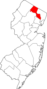 Location within the U.S. state of New Jersey | |
 New Jersey's location within the U.S. | |
| Coordinates: 41.03°N 74.30°W | |
| Country | |
| State | |
| Founded | February 7, 1837[1] |
| Named for | "Pasaeck", a Lenape word meaning "valley" |
| Seat | Paterson[2] |
| Largest city | Paterson (population) West Milford (area) |
| Government | |
| • Freeholder director | John W. Bartlett (D, term ends December 31, 2019) |
| Area | |
| • Total | 197.10 sq mi (510.5 km2) |
| • Land | 184.59 sq mi (478.1 km2) |
| • Water | 12.51 sq mi (32.4 km2) 6.35% |
| Population (2010) | |
| • Total | 501,226 |
| • Estimate (2019) | 501,826 |
| • Density | 2,500/sq mi (980/km2) |
| Congressional districts | 5th, 9th, 11th |
| Website | www |

As of the 2010 census, the population was 501,226,[3] an increase of 12,177 (+2.5%) from the 489,049 counted in the 2000 Census,[4][5][6] As of the 2019 Census estimate, the county's population was 501,826, making it the state's ninth-most populous county,[7][8][9] and marking an increase of 2.3% from 2010.[3] Its county seat is Paterson.[2] The most populous place was Paterson, with 146,199 residents at the time of the 2010 Census, more than 29% of the county's population, while West Milford covered 80.32 square miles (208.0 km2), the largest total area of any municipality and more than 40% of the county's area.[6]
Passaic County was created on February 7, 1837, from portions of Bergen County and Essex County.[1]
Geography
The landscape of Passaic County, near the north edge of New Jersey, spans some hilly areas and has dozens of lakes. The county covers a region about 30 × 20 miles wide (48 × 32 km). The region is split by major roads, including portions of Interstate 287 and I-80, near Paterson (see map at left). The Garden State Parkway (GSP) cuts across the southern end, near Clifton. The Passaic River winds northeast past Totowa into Paterson, where the river then turns south to Passaic town, on the way to Newark, further south.
The highest point is any one of six areas on Bearfort Ridge in West Milford at approximately 1,480 feet (450 m) above sea level.[10] The lowest elevation is approximately 20 feet (6.1 m) along the Passaic River in Clifton.
The southeastern, more populous half of the county is either flat near the river or mildly hilly. The northwestern section is rugged and mountainous.
According to the 2010 Census, the county had a total area of 197.10 square miles (510.5 km2), including 184.59 square miles (478.1 km2) of land (93.7%) and 12.51 square miles (32.4 km2) of water (6.35%).[6][11]
Climate and weather
| Paterson, New Jersey | ||||||||||||||||||||||||||||||||||||||||||||||||||||||||||||
|---|---|---|---|---|---|---|---|---|---|---|---|---|---|---|---|---|---|---|---|---|---|---|---|---|---|---|---|---|---|---|---|---|---|---|---|---|---|---|---|---|---|---|---|---|---|---|---|---|---|---|---|---|---|---|---|---|---|---|---|---|
| Climate chart (explanation) | ||||||||||||||||||||||||||||||||||||||||||||||||||||||||||||
| ||||||||||||||||||||||||||||||||||||||||||||||||||||||||||||
| ||||||||||||||||||||||||||||||||||||||||||||||||||||||||||||
In recent years, average temperatures in the county seat of Paterson have ranged from a low of 19 °F (−7 °C) in January to a high of 86 °F (30 °C) in July, although a record low of −11 °F (−24 °C) was recorded in January 1961 and a record high of 105 °F (41 °C) was recorded in September 1953. Average monthly precipitation ranged from 2.86 inches (73 mm) in February to 4.78 inches (121 mm) in September.[12] The county has a humid continental climate which is hot-summer (Dfa) except in higher areas to the north where it is warm-summer (Dfb).
Demographics
| Historical population | |||
|---|---|---|---|
| Census | Pop. | %± | |
| 1840 | 16,734 | — | |
| 1850 | 22,569 | 34.9% | |
| 1860 | 29,013 | 28.6% | |
| 1870 | 46,416 | 60.0% | |
| 1880 | 68,860 | 48.4% | |
| 1890 | 105,046 | 52.6% | |
| 1900 | 155,202 | 47.7% | |
| 1910 | 215,902 | 39.1% | |
| 1920 | 259,174 | 20.0% | |
| 1930 | 302,129 | 16.6% | |
| 1940 | 309,353 | 2.4% | |
| 1950 | 337,093 | 9.0% | |
| 1960 | 406,618 | 20.6% | |
| 1970 | 460,782 | 13.3% | |
| 1980 | 447,585 | −2.9% | |
| 1990 | 453,060 | 1.2% | |
| 2000 | 489,049 | 7.9% | |
| 2010 | 501,226 | 2.5% | |
| Est. 2019 | 501,826 | [13] | 0.1% |
| Historical sources: 1790-1990[14] 1970-2010[6] 2000[4] 2010[3] 2000-2010[15] 2010-2019 | |||
2010 Census
The 2010 United States Census counted 501,226 people, 166,785 households, and 120,919.125 families in the county. The population density was 2,715.3 per square mile (1,048.4/km2). There were 175,966 housing units at an average density of 953.3 per square mile (368.1/km2). The racial makeup was 62.65% (314,001) White, 12.83% (64,295) Black or African American, 0.67% (3,348) Native American, 5.01% (25,092) Asian, 0.03% (156) Pacific Islander, 15.11% (75,735) from other races, and 3.71% (18,599) from two or more races. Hispanic or Latino of any race were 37.04% (185,677) of the population.[3]
Of the 166,785 households, 34.5% had children under the age of 18; 48.7% were married couples living together; 17.5% had a female householder with no husband present and 27.5% were non-families. Of all households, 22.6% were made up of individuals and 9.4% had someone living alone who was 65 years of age or older. The average household size was 2.94 and the average family size was 3.45.[3]
24.9% of the population were under the age of 18, 10.3% from 18 to 24, 27.1% from 25 to 44, 25.7% from 45 to 64, and 12% who were 65 years of age or older. The median age was 36.1 years. For every 100 females, the population had 94.2 males. For every 100 females ages 18 and older there were 91.1 males.[3]
Same-sex couples headed one in 149 households in 2010.[16]
2000 Census
As of the 2000 United States Census[17] there were 489,049 people, 163,856 households, and 119,614 families residing in the county. The population density was 2,639 people per square mile (1,019/km²). There were 170,048 housing units at an average density of 918 per square mile (354/km²). The racial makeup of the county was 62.32% White, 13.22% Black or African American, 0.44% Native American, 3.69% Asian, 0.04% Pacific Islander, 16.24% from other races, and 4.05% from two or more races. 29.95% of the population were Hispanic or Latino of any race.[4][18] Among those who reported their ancestry, 16.6% were of Italian, 9.5% Irish, 8.1% German and 6.2% Polish ancestry according to Census 2000.[18][19]
There were 163,856 households out of which 35.60% had children under the age of 18 living with them, 51.50% were married couples living together, 16.00% had a female householder with no husband present, and 27.00% were non-families. 22.20% of all households were made up of individuals and 9.50% had someone living alone who was 65 years of age or older. The average household size was 2.92 and the average family size was 3.42.[4]
In the county, the population was spread out with 26.10% under the age of 18, 9.30% from 18 to 24, 31.30% from 25 to 44, 21.30% from 45 to 64, and 12.10% who were 65 years of age or older. The median age was 35 years. For every 100 females, there were 94.00 males. For every 100 females age 18 and over, there were 90.80 males.[4]
The median income for a household in the county was $49,210, and the median income for a family was $56,054. Males had a median income of $38,740 versus $29,954 for females. The per capita income for the county was $21,370. About 9.40% of families and 12.30% of the population were below the poverty line, including 17.30% of those under age 18 and 9.20% of those age 65 or over.[18][20]
Law, government, policing

The Passaic County Court House and Administrative Building complex is located at the county seat in Paterson.[21]
In Passaic County's commission form of government, the Board of Chosen Freeholders discharge both executive and legislative responsibilities. Seven Freeholders are elected at-large for three-year terms on a staggered basis. A Freeholder Director and Freeholder Deputy Director are elected from among the seven Freeholders at an annual reorganization meeting in January.[22] Passaic County operates through six standing committees of the Board of Chosen Freeholders. They are Administration & Finance; Health, Education and Community Affairs; Public Works and Buildings & Grounds; Law & Public Safety; Human Services and Planning and Economic Development. The Freeholders also appoint individuals to departments, agencies, boards and commissions for the effective administration of county government. In 2016, freeholders were paid $28,500 and the freeholder director was paid an annual salary of $29,500.[23] The Freeholders select a County Administrator who, in the role of chief administrative officer, supervises the day-to-day operation of county government and its departments; Anthony J. DeNova III is the County Administrator.[24]
As of 2019, Passaic County's Freeholders are:[25][26][27]
- Freeholder Director John W. Bartlett (D, term as freeholder ends December 31, 2021 / term as freeholder director ends 2019; Wayne)
- Freeholder Deputy Director Cassandra "Sandi" Lazzara (D, term as freeholder ends 2021 / term as freeholder deputy director ends 2019; Little Falls)
- Assad Akhter (D, 2021; Paterson)
- Theodore O. Best Jr. (D, 2020; Paterson)
- Terry Duffy (D, 2022; West Milford)
- Bruce James (D, 2020; Clifton)
- Pat Lepore (D, 2022; Woodland Park)
Pursuant to Article VII Section II of the New Jersey State Constitution, each county in New Jersey is required to have three elected administrative officials known as "constitutional officers." These officers are the County Clerk and County Surrogate (both elected for five-year terms of office) and the County Sheriff (elected for a three-year term).[28] Constitutional officers. elected on a countywide basis are:[27]
- County Clerk Danielle Ireland-Imhof (D, 2023)[29][30][31]
- Sheriff Richard H. Berdnik (D, 2022)[32][33]
- Surrogate Bernice Toledo (D, 2021)[34][35]
The Passaic County Prosecutor is Camelia M. Valdes of Bloomingdale, who was nominated by Governor of New Jersey Jon S. Corzine in May 2009 and renominated by Governor Chris Christie in June 2015.[36][37]
Passaic County constitutes Vicinage 11 of the New Jersey Superior Court and is seated at the Passaic County Courthouse in Paterson; the Assignment Judge for Vicinage 11 is Ernest M. Caposela.[38] Law enforcement at the county level is provided by the Passaic County Sheriff and the Passaic County Prosecutor's Office.
Three federal Congressional Districts cover the county, with most of the northern portion of the county in the 5th District, most of the southern portion of the county in the 9th District and the central portion of the county in the 11th District.[39][40] For the 116th United States Congress, New Jersey's Fifth Congressional District is represented by Josh Gottheimer (D, Wyckoff).[41][42] For the 116th United States Congress, New Jersey's Ninth Congressional District is represented by Bill Pascrell (D, Paterson).[43][44] For the 116th United States Congress, New Jersey's Eleventh Congressional District is represented by Mikie Sherrill (D, Montclair).[45]
The county is part of the 26th, 34th, 35th, 36th, 38th, 39th and 40th Districts in the New Jersey Legislature.[46] For the 2018–2019 session (Senate, General Assembly), the 26th Legislative District of the New Jersey Legislature is represented in the State Senate by Joseph Pennacchio (R, Montville) and in the General Assembly by BettyLou DeCroce (R, Parsippany-Troy Hills) and Jay Webber (R, Morris Plains).[47][48] For the 2018–2019 session (Senate, General Assembly), the 34th Legislative District of the New Jersey Legislature is represented in the State Senate by Nia Gill (D, Montclair) and in the General Assembly by Thomas P. Giblin (D, Montclair) and Britnee Timberlake (D, East Orange).[49][50] Timberlake was sworn into office on January 29, 2018 to fill the seat of Sheila Oliver, who had resigned from office on January 9, 2018 to become Lieutenant Governor of New Jersey.[51][52] For the 2018–2019 session (Senate, General Assembly), the 35th Legislative District of the New Jersey Legislature is represented in the State Senate by Nellie Pou (D, North Haledon) and in the General Assembly by Shavonda E. Sumter (D, Paterson) and Benjie E. Wimberly (D, Paterson).[53][54] For the 2018–2019 session (Senate, General Assembly), the 36th Legislative District of the New Jersey Legislature is represented in the State Senate by Paul Sarlo (D, Wood-Ridge) and in the General Assembly by Gary Schaer (D, Passaic) and Clinton Calabrese (D, Cliffside Park).[55][56] Calabrese was sworn into office on February 8, 2018 to fill the seat of Marlene Caride, who had resigned from office on January 16, 2018 after being nominated to head the New Jersey Department of Banking and Insurance.[57][58] For the 2018–2019 session (Senate, General Assembly), the 38th Legislative District of the New Jersey Legislature is represented in the State Senate by Joseph Lagana (D, Paramus) and in the General Assembly by Lisa Swain (D, Fair Lawn) and Chris Tully (D, Bergenfield).[59][60] In May 2018, Lagana took the Senate seat after Robert M. Gordon left office, while Swain and Tully took the seats vacated by Tim Eustace and Lagana.[61] For the 2018–2019 session (Senate, General Assembly), the 39th Legislative District of the New Jersey Legislature is represented in the State Senate by Gerald Cardinale (R, Demarest) and in the General Assembly by Holly Schepisi (R, River Vale) and Robert Auth (R, Old Tappan).[62][63] For the 2018–2019 session (Senate, General Assembly), the 40th Legislative District of the New Jersey Legislature is represented in the State Senate by Kristin Corrado (R, Totowa) and in the General Assembly by Kevin J. Rooney (R, Wyckoff) and Christopher DePhillips (R, Wyckoff).[64][65]
Highlands protection
In 2004, the New Jersey Legislature passed the Highlands Water Protection and Planning Act, which regulates the New Jersey Highlands region. The northwestern area of the county, comprising the municipalities of Bloomingdale, Pompton Lakes, Ringwood, Wanaque and West Milford, was included in the highlands preservation area and is subject to the rules of the act and the Highlands Water Protection and Planning Council, a division of the New Jersey Department of Environmental Protection.[66] Some of the territory in the protected region is classified as being in the highlands preservation area, and thus subject to additional rules.[67]
Policing
The Passaic County sheriff's department provides law enforcement functions throughout entire Passaic County plus unincorporated county area police patrol, detective, crime scene investigation, SWAT, K-9 function, operation of the Passaic County Jail, and the security of all county owned facilities, including the Passaic County Courthouse/Administration Complex. The incorporated cities within the county: Paterson, Passaic City, Clifton, Bloomingdale, Pompton Lakes, Prospect Park have separate municipal police departments.
Politics
As of March 23, 2011, there were a total of 266,617 registered voters in Passaic County, of which 82,529 (31.0%) were registered as Democrats, 49,852 (18.7%) were registered as Republicans and 134,152 (50.3%) were registered as Unaffiliated. There were 84 voters registered to other parties.[68] Among the county's 2010 Census population, 53.2% (vs. 53.2% in Passaic County) were registered to vote, including 70.8% of those ages 18 and over (vs. 70.8% countywide).[68][69]
In the 2008 presidential election, Democrat Barack Obama received 58.8% of the vote here (113,257 cast), ahead of Republican John McCain with 37.7% (72,552 votes) and other candidates with 0.8% (1,586 votes), among the 192,558 ballots cast by the county's 273,483 registered voters, for a turnout of 70.4%.[70] In the 2004 presidential election, Democrat John Kerry received 53.9% of the vote here (94,962 ballots cast), outpolling Republican George W. Bush with 42.7% (75,200 votes) and other candidates with 0.5% (1,149 votes), among the 176,303 ballots cast by the county's 254,569 registered voters, for a turnout percentage of 69.3.[71]
| Year | Republican | Democratic | Third parties |
|---|---|---|---|
| 2016 | 37.2% 72,902 | 59.5% 116,759 | 3.4% 6,567 |
| 2012 | 35.4% 64,523 | 63.6% 115,926 | 1.0% 1,765 |
| 2008 | 38.7% 72,552 | 60.3% 113,257 | 1.0% 1,904 |
| 2004 | 43.9% 75,200 | 55.4% 94,962 | 0.7% 1,149 |
| 2000 | 39.0% 61,043 | 57.7% 90,324 | 3.3% 5,206 |
| 1996 | 35.0% 53,594 | 56.2% 85,879 | 8.8% 13,478 |
| 1992 | 43.2% 71,147 | 42.5% 70,030 | 14.4% 23,711 |
| 1988 | 55.9% 88,070 | 42.1% 66,254 | 2.0% 3,189 |
| 1984 | 58.3% 101,951 | 39.8% 69,590 | 1.9% 3,399 |
| 1980 | 51.9% 82,531 | 38.7% 61,486 | 9.4% 14,934 |
| 1976 | 51.2% 85,102 | 45.8% 76,194 | 3.0% 4,930 |
| 1972 | 62.0% 108,511 | 35.6% 62,302 | 2.4% 4,110 |
| 1968 | 46.3% 79,862 | 43.1% 74,442 | 10.6% 18,353 |
| 1964 | 35.1% 63,114 | 63.4% 113,919 | 1.5% 2,666 |
| 1960 | 45.1% 80,853 | 50.7% 90,950 | 4.2% 7,599 |
| 1956 | 60.7% 101,182 | 37.1% 61,859 | 2.2% 3,635 |
| 1952 | 54.3% 89,083 | 43.1% 70,727 | 2.7% 4,380 |
| 1948 | 45.8% 59,675 | 46.1% 60,147 | 8.1% 10,608 |
| 1944 | 49.5% 67,856 | 50.1% 68,737 | 0.4% 589 |
| 1940 | 48.2% 65,523 | 51.4% 69,880 | 0.4% 504 |
| 1936 | 40.1% 49,046 | 58.4% 71,384 | 1.4% 1,760 |
| 1932 | 45.0% 49,218 | 49.9% 54,576 | 5.1% 5,610 |
| 1928 | 54.5% 57,708 | 44.6% 47,167 | 0.9% 959 |
| 1924 | 62.3% 43,384 | 16.7% 11,644 | 20.9% 14,571 |
| 1920 | 72.1% 42,692 | 20.1% 11,873 | 7.9% 4,660 |
| 1916 | 55.3% 18,754 | 39.4% 13,340 | 5.3% 1,810 |
| 1912 | 17.5% 5,349 | 35.4% 10,810 | 47.1% 14,372 |
| 1908 | 56.0% 17,638 | 38.0% 11,960 | 6.1% 1,918 |
| 1904 | 56.4% 17,705 | 36.7% 11,532 | 6.9% 2,150 |
| 1900 | 53.0% 15,619 | 43.7% 12,892 | 3.3% 973 |
| County CPVI: D+11 | |||
In the 2009 gubernatorial election, Democrat Jon Corzine received 50.8% of the vote here (57,010 ballots cast), ahead of Republican Chris Christie with 43.2% (48,500 votes), Independent Chris Daggett with 3.8% (4,288 votes) and other candidates with 0.9% (981 votes), among the 112,278 ballots cast by the county's 262,723 registered voters, yielding a 42.7% turnout.[73]
Municipalities
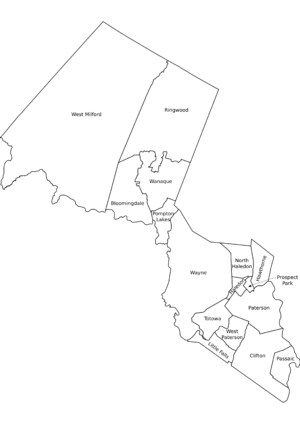
Municipalities in Passaic County (with 2010 Census data for population, housing units and area in square miles) are:[74] Other, unincorporated communities in the county are listed next to their parent municipality. Most of these areas are census-designated places (CDPs) that have been created by the United States Census Bureau for enumeration purposes within a Township. Other communities and enclaves that exist within a municipality are also listed next to the name.
| Municipality | Mun. type |
Pop. | Housing units |
Total area |
Water area |
Land Area |
Pop. density |
Housing density |
School district | Unincorporated communities / notes |
|---|---|---|---|---|---|---|---|---|---|---|
| Bloomingdale | borough | 7,656 | 3,089 | 9.17 | 0.45 | 8.71 | 878.6 | 354.5 | Butler (9-12) (S/R) Bloomingdale (K-8) | |
| Clifton | city | 84,136 | 31,946 | 11.40 | 0.14 | 11.26 | 7,472.0 | 2,837.1 | Clifton | |
| Haledon | borough | 8,318 | 2,932 | 1.16 | 0.00 | 1.15 | 7,203.9 | 2,539.3 | Manchester (9-12) Haledon (PK-8) | |
| Hawthorne | borough | 18,791 | 7,756 | 3.36 | 0.03 | 3.33 | 5,635.3 | 2,326.0 | Hawthorne | |
| Little Falls | township | 14,432 | 4,925 | 2.81 | 0.07 | 2.74 | 5,276.2 | 1,800.5 | Passaic Valley (9-12) Little Falls (K-8) | Great Notch Singac CDP (3,618) |
| North Haledon | borough | 8,417 | 3,213 | 3.50 | 0.04 | 3.45 | 2,436.8 | 930.2 | Manchester (9-12) North Haledon (PK-8) | |
| Passaic | city | 69,781 | 20,432 | 3.24 | 0.10 | 3.15 | 22,179.6 | 6,494.2 | Passaic | |
| Paterson | city | 146,199 | 47,946 | 8.70 | 0.28 | 8.43 | 17,346.3 | 5,688.7 | Paterson | |
| Pompton Lakes | borough | 11,097 | 4,341 | 3.19 | 0.28 | 2.91 | 3,809.1 | 1,490.1 | Pompton Lakes | |
| Prospect Park | borough | 5,865 | 1,931 | 0.48 | 0.00 | 0.48 | 12,347.2 | 4,065.2 | Manchester (9-12) Prospect Park (PK-8) | |
| Ringwood | borough | 12,228 | 4,331 | 28.17 | 2.96 | 25.21 | 485.0 | 171.8 | Lakeland (9-12) Ringwood (K-8) | |
| Totowa | borough | 10,804 | 3,918 | 4.07 | 0.07 | 3.99 | 2,704.9 | 980.9 | Passaic Valley (9-12) Totowa (PK-8) | |
| Wanaque | borough | 11,116 | 4,184 | 9.25 | 1.26 | 7.99 | 1,391.2 | 523.7 | Lakeland (9-12) Wanaque (PK-8) | Haskell |
| Wayne | township | 54,717 | 19,768 | 25.17 | 1.45 | 23.73 | 2,306.0 | 833.1 | Wayne | Packanack Lake Pines Lake Preakness |
| West Milford | township | 25,850 | 10,419 | 80.32 | 5.23 | 75.09 | 344.3 | 138.8 | West Milford | Cooper Hewitt Macopin Newfoundland Oak Ridge |
| Woodland Park | borough | 11,819 | 4,835 | 3.11 | 0.15 | 2.96 | 3,987.9 | 1,631.4 | Passaic Valley (9-12) Woodland Park (K-8) | (formerly West Paterson) |
| Passaic County | county | 501,226 | 175,966 | 197.11 | 12.51 | 184.59 | 2,715.3 | 953.3 |
Economy
- Toys "R" Us' former US corporate headquarters[75] was in Wayne, NJ
- Valley National Bank's corporate headquarters is in Wayne, NJ.[76]
- Linens ‘n Things's headquarters office was in Clifton, NJ and employed 17,500 before closing in 2009.
- JVC has their US office in Wayne and employ approximately 19,040.[77]
Education
- Passaic County Community College, founded in 1971, serves students from Passaic County at campuses in Paterson, Wanaque and Wayne.[78]
- William Paterson University, established in 1855, is a public university located in Wayne.[79]
- Montclair State University, founded in 1908, is a public university located in Montclair, as well as portions of Little Falls and Clifton.[80]
Media
Passaic County is served by New York City-based commercial television & radio stations and New Jersey Network public television.
Points of interest
- Dey Mansion, in Preakness, Wayne, served as Washington's Headquarters on several occasions during the American Revolutionary War.[81]
- Garret Mountain Reservation in Paterson and Woodland Park is a National Natural Landmark covering 568 acres (230 ha).[82]
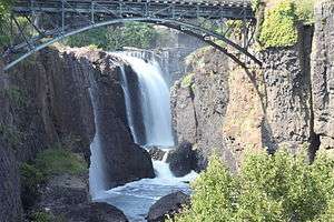
- Paterson Great Falls National Historical Park in Paterson[83]
- High Mountain Park Preserve in Wayne[84]
- Lambert Castle in Paterson[85]
- Long Pond Ironworks State Park in West Milford[86]
- Paterson Museum, housed in the Rogers Locomotive and Machine Works in Paterson[87]
- Ringwood State Park in Ringwood[88]
- Skylands, the New Jersey State Botanical Garden in Ringwood, are formal gardens that are open to the public year-round. Originally constructed for Clarence MacKenzie Lewis in the 1920s, the entire property was acquired by the State of New Jersey in 1966 to form a State Botanical Garden covering 4,000-acre (16 km2) which include a Lilac Garden, Magnolia Walk, the Wild Flower Garden, the Crab Apple Vista, an allée of 166 trees extending almost a half-mile, and the Perennial Garden.[89]
- Yogi Berra Stadium in Little Falls - Located on the campus of Montclair State University, the stadium is home to the New Jersey Jackals of the independent Can-Am League as well as Montclair State's baseball team. The stadium has a capacity of 5,000 persons with permanent seating of 3,784 people and lawn seating which holds an additional 1,500.[90]
References
- Snyder, John P. The Story of New Jersey's Civil Boundaries: 1606-1968, Bureau of Geology and Topography; Trenton, New Jersey; 1969. p. 209. Accessed December 2, 2012.
- New Jersey County Map, New Jersey Department of State. Accessed July 10, 2017.
- DP-1: Profile of General Population and Housing Characteristics: 2010; 2010 Demographic Profile Data for Passaic County, New Jersey, United States Census Bureau. Accessed January 13, 2013.
- DP-1 - Profile of General Demographic Characteristics: 2000; Census 2000 Summary File 1 (SF 1) 100-Percent Data for Passaic County, New Jersey, United States Census Bureau. Accessed January 23, 2013.
- NJ Labor Market Views Archived 2013-09-20 at the Wayback Machine, New Jersey Department of Labor and Workforce Development, March 15, 2011. Accessed October 6, 2013.
- New Jersey: 2010 - Population and Housing Unit Counts; 2010 Census of Population and Housing, p. 6, CPH-2-32. United States Census Bureau, August 2012. Accessed August 29, 2016.
- QuickFacts - Passaic County, New Jersey; New Jersey; United States, United States Census Bureau. Accessed March 24, 2018.
- Annual Estimates of the Resident Population: April 1, 2010 to July 1, 2017 - 2017 Population Estimates Archived February 13, 2020, at Archive.today, United States Census Bureau. Accessed March 24, 2018.
- GCT-PEPANNCHG: Estimates of Resident Population Change and Rankings: July 1, 2016 to July 1, 2017 - State -- County / County Equivalent from the 2017 Population Estimates for New Jersey Archived February 13, 2020, at Archive.today, United States Census Bureau. Accessed March 24, 2018.
- New Jersey County High Points, Peakbagger.com. Accessed October 5, 2013.
- Census 2010 U.S. Gazetteer Files: New Jersey Counties, United States Census Bureau, Backed up by the Internet Archive as of June 11, 2012. Accessed October 6, 2013.
- Monthly Averages for Paterson, New Jersey, The Weather Channel. Accessed October 13, 2012.
- "Population and Housing Unit Estimates". Retrieved March 26, 2020.
- Forstall, Richard L. Population of states and counties of the United States: 1790 to 1990 from the Twenty-one Decennial Censuses, pp. 108-109. United States Census Bureau, March 1996. ISBN 9780934213486. Accessed October 6, 2013.
- U.S. Census Bureau Delivers New Jersey's 2010 Census Population Totals, United States Census Bureau, February 3, 2011. Accessed February 5, 2011.
- Lipman, Harvy; and Sheingold, Dave. "North Jersey sees 30% growth in same-sex couples", The Record (Bergen County), August 14, 2011, backed up by the Internet Archive as of February 3, 2013. Accessed August 31, 2014.
- U.S. Census website , United States Census Bureau. Accessed September 4, 2014.
- Tables DP-1 to DP-4 from Census 2000 for Passaic County, New Jersey, United States Census Bureau, backed up by the Internet Archive as of July 6, 2008. Accessed October 1, 2013.
- DP-2 - Profile of Selected Social Characteristics: 2000 from the Census 2000 Summary File 3 (SF 3) - Sample Data for Passaic County, New Jersey, United States Census Bureau. Accessed September 30, 2013.
- DP-3 - Profile of Selected Economic Characteristics: 2000 from Census 2000 Summary File 3 (SF 3) - Sample Data for Passaic County, New Jersey, United States Census Bureau. Accessed September 30, 2013.
- Passaic County Courthouse/Administration Complex , Emporis. Accessed July 9, 2015.
- Board of Chosen Freeholders, Passaic County, New Jersey. Accessed October 18, 2019.
- Gallo Jr., Bill. "Which N.J. county freeholders are paid the most?", NJ.com, March 11, 2016. Accessed October 25, 2017. "Freeholder director: $29,500; Other freeholders: $28,500"
- Administration, Passaic County, New Jersey. Accessed October 18, 2019.
- Meet Your Freeholders, Passaic County, New Jersey. Accessed October 18, 2019.
- 2019 County Data Sheet, Passaic County, New Jersey. Accessed October 18, 2019.
- Passaic County 2019 Directory, Passaic County, New Jersey. Accessed October 18, 2019.
- New Jersey State Constitution (1947), Article VII, Section II, Paragraph 2, New Jersey Department of State. Accessed October 26, 2017.
- Passaic County Clerk, Passaic County, New Jersey. Accessed October 18, 2019.
- Members List: Clerks, Constitutional Officers Association of New Jersey. Accessed October 18, 2019.
- "Official Results - 2018 General Election - Summary" (PDF). Passaic County, New Jersey. Passaic County Clerk. Retrieved 18 October 2019.
- Sheriff Richard H. Berdnik, Passaic County Sheriff's Office. Accessed October 24, 2017.
- Members List: Sheriffs, Constitutional Officers Association of New Jersey. Accessed October 22, 2017.
- Our Surrogate, Passaic County, New Jersey. Accessed October 18, 2019.
- Members List: Surrogates, Constitutional Officers Association of New Jersey. Accessed October 22, 2017.
- Prosecutor Camelia M. Valdes, Passaic County, New Jersey. Accessed October 18, 2019.
- "Governor Chris Christie Files Nominations", Governor of New Jersey Chris Christie, press release dated June 15, 2015. Accessed October 29, 2017. "PASSAIC COUNTY PROSECUTOR - Nominate for reappointment Camelia M. Valdes (Bloomingdale, Passaic))"
- Passaic Vicinage, New Jersey Courts. Accessed October 24, 2017.
- 2012 Congressional Districts by County, New Jersey Department of State Division of Elections. Accessed October 6, 2013.
- Plan Components Report, New Jersey Department of State Division of Elections, December 23, 2011. Accessed October 6, 2013.
- Directory of Representatives: New Jersey, United States House of Representatives. Accessed January 3, 2019.
- Biography, Congressman Josh Gottheimer. Accessed January 3, 2019. "Josh now lives in Wyckoff, New Jersey with Marla, his wife who was a federal prosecutor, and their two young children, Ellie and Ben."
- Directory of Representatives: New Jersey, United States House of Representatives. Accessed January 3, 2019.
- Biography, Congressman Bill Pascrell. Accessed January 3, 2019."A native son of Paterson, N.J., Congressman Bill Pascrell, Jr. has built a life of public service upon the principles he learned while growing up on the south side of the Silk City."
- Directory of Representatives: New Jersey, United States House of Representatives. Accessed January 3, 2019.
- 2011 Legislative Districts by County, New Jersey Department of State Division of Elections. Accessed October 6, 2013.
- Legislative Roster 2018-2019 Session, New Jersey Legislature. Accessed January 22, 2018.
- District 26 Legislators, New Jersey Legislature. Accessed January 22, 2018.
- Legislative Roster 2018-2019 Session, New Jersey Legislature. Accessed January 29, 2018.
- District 34 Legislators, New Jersey Legislature. Accessed January 29, 2018.
- "Timberlake Sworn-In to Serve Legislative District 34". Insider NJ. January 29, 2018. Retrieved January 29, 2018.
- "NEW JERSEY LEGISLATIVE DIGEST for January 9, 2018". Office of Legislative Services. January 11, 2018. Retrieved January 29, 2018.
- Legislative Roster 2018-2019 Session, New Jersey Legislature. Accessed January 22, 2018.
- District 35 Legislators, New Jersey Legislature. Accessed January 22, 2018.
- Legislative Roster 2018-2019 Session, New Jersey Legislature. Accessed January 22, 2018.
- District 36 Legislators, New Jersey Legislature. Accessed January 22, 2018.
- Wildstein, David (January 24, 2018). "Calabrese unopposed for Caride seat". Politics DW. Retrieved February 9, 2018.
Caride resigned last week, following Gov. Phil Murphy’s inauguration. She is currently the Acting Commissioner of Banking and Insurance as she awaits State Senate confirmation.
- Johnson, Brent (February 8, 2018). "Meet the newest -- and youngest -- N.J. lawmaker". NJ.com. Retrieved February 9, 2018.
- Legislative Roster 2018-2019 Session, New Jersey Legislature. Accessed July 3, 2018.
- District 38 Legislators, New Jersey Legislature. Accessed July 3, 2018.
- Johnson, Brent. "Meet your 3 new state lawmakers, New Jersey", NJ Advance Media for NJ.com, May 25, 2018. Accessed July 3, 2018. "Swain, the former mayor of Fair Lawn, and Tully, the former council president in Bergenfield, will be district mates. They replace Joseph Lagana, who moved up to the state Senate last month when state Sen. Robert Gordon resigned to join the state Board of Public Utilities, and Tim Eustace, who resigned last month to take a job outside of state government."
- Legislative Roster 2018-2019 Session, New Jersey Legislature. Accessed January 22, 2018.
- District 39 Legislators, New Jersey Legislature. Accessed January 22, 2018.
- Legislative Roster 2018-2019 Session, New Jersey Legislature. Accessed January 22, 2018.
- District 40 Legislators, New Jersey Legislature. Accessed January 22, 2018.
- Assembly Committee Substitute for Assembly, No. 2635, New Jersey Legislature, June 7, 2004. Accessed October 31, 2014.
- DEP Guidance for the Highlands Water Protection and Planning Act-Highlands Region Counties and Municipalities; Highlands Municipalities, New Jersey Department of Environmental Protection, updated July 8, 2014. Accessed October 31, 2014.
- Voter Registration Summary - Passaic, New Jersey Department of State Division of Elections, March 23, 2011. Accessed January 13, 2013.
- GCT-P7: Selected Age Groups: 2010 - State -- County Subdivision; 2010 Census Summary File 1 for New Jersey , United States Census Bureau. Accessed January 13, 2013.
- 2008 Presidential General Election Results: Passaic County, New Jersey Department of State Division of Elections, December 23, 2008. Accessed January 13, 2013.
- 2004 Presidential Election: Passaic County, New Jersey Department of State Division of Elections, December 13, 2004. Accessed January 13, 2013.
- Leip, David. "Dave Leip's Atlas of U.S. Presidential Elections". uselectionatlas.org. Retrieved 2018-06-10.
- 2009 Governor: Passaic County Archived 2012-08-22 at the Wayback Machine, New Jersey Department of State Division of Elections, December 31, 2009. Accessed January 13, 2013.
- GCT-PH1: Population, Housing Units, Area, and Density: 2010 - County -- County Subdivision and Place from the 2010 Census Summary File 1 for Passaic County, New Jersey, United States Census Bureau. Accessed January 19, 2014.
- About Toys "R" Us, Inc., Toys "R" Us, Inc. Accessed August 22, 2014. "Headquartered in Wayne, NJ, Toys"R"Us, Inc. employs approximately 70,000 employees worldwide."
- Company Information, Valley National Bank. Accessed August 22, 2014. "Valley National Bancorp is a regional bank holding company headquartered in Wayne, New Jersey with $16 billion in assets."
- http://www.jvc.com › Company
- President's Message, Passaic County Community College. Accessed October 6, 2013.
- University Facts, William Paterson University. Accessed October 6, 2013.
- At a Glance, Montclair State University. Accessed October 6, 2013.
- Dey Mansion, Passaic County, New Jersey. Accessed October 24, 2017.
- Garret Mountain Reservation, Passaic County, New Jersey. Accessed October 24, 2017.
- Paterson Great Falls National Historical Park, National Park Service. Accessed October 24, 2017.
- High Mountain Park Preserve, New York–New Jersey Trail Conference. Accessed October 27, 2017.
- Lambert Castle, Passaic County, New Jersey. Accessed October 24, 2017.
- Long Pond Ironworks State Park, New Jersey Department of Environmental Protection Division of Parks and Forestry. Accessed October 24, 2017.
- Paterson Museum, Passaic, New Jersey. Accessed October 24, 2017.
- Ringwood State Park, New Jersey Department of Environmental Protection Division of Parks and Forestry. Accessed October 24, 2017.
- About NJBG, New Jersey State Botanical Garden. Accessed August 31, 2014. "Skylands was sold in 1922 to Clarence McKenzie Lewis (1877-1959), an investment banker and also a trustee of the New York Botanical Garden. When Mr. Lewis purchased the property, he set out to make it a botanical showplace.... In 1966, New Jersey purchased the 1,117 acres of Skylands from Shelton College, which had used it as a campus."
- Yogi Berra Stadium History, New Jersey Jackals. Accessed August 31, 2014.
External links
| Wikimedia Commons has media related to Passaic County, New Jersey. |
Places adjacent to Passaic County, New Jersey | ||||||||||
|---|---|---|---|---|---|---|---|---|---|---|
| ||||||||||
Municipalities and communities of Passaic County, New Jersey, United States | ||
|---|---|---|
| Cities | Map of New Jersey highlighting Passaic County | |
| Boroughs | ||
| Townships | ||
| CDPs | ||
| Other unincorporated communities | ||
| Authority control |
|
|---|