Nanjemoy, Maryland
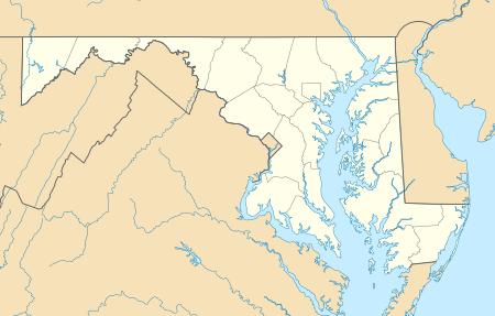
Nanjemoy is a settlement along Maryland Route 6 in southwestern Charles County, Maryland, United States, and the surrounding large rural area more or less bounded by Nanjemoy Creek to the east and north, and the Potomac River to the south and west.
Nanjemoy, Maryland | |
|---|---|
 Nanjemoy Location within the state of Maryland  Nanjemoy Nanjemoy (the United States) | |
| Coordinates: 38°27′17″N 77°13′01″W | |
| Country | United States |
| State | Maryland |
| County | Charles |
| Time zone | UTC-5 (Eastern (EST)) |
| • Summer (DST) | UTC-4 (EDT) |
| ZIP codes | 20662 |
Geography
Nanjemoy is within the Washington, D.C., metropolitan area, approximately 25 miles (40 km) south of the Capital Beltway (Interstates 95 and 495).
The area is served by Maryland Route 6 and other two-lane state highways; the nearest major roads are Maryland Route 210 to the north and U.S. Route 301 to the east. The Nanjemoy area is becoming increasingly popular with Washington-area commuters, particularly those working in nearby Indian Head or Fort Washington in Maryland or in Alexandria, Virginia. The Waldorf, Maryland and La Plata, Maryland, commercial areas are nearby to the east, along U.S. 301. No rail lines presently serve the area. Other settlements in the Nanjemoy area include Grayton, Maryland Point, and Riverside. Chickamuxen, Doncaster, and Ironsides are nearby to the north.
Economy
The village center includes a Post Office and a county-operated community center building that serves the area's population. The area has two children's camps and a sheriffs' training facility . Much of the Nanjemoy area is forest or farmland. Tobacco was formerly commonly cultivated in the area, but is now rarely grown there.
History
Nanjemoy and the creek draw their names from a Native American tribe. The Confederate-sympathizing area saw occupation by a large force of the Union army during the early part of the American Civil War, with an encampment of about 12,000 soldiers near Chicamuxen,[1] a few miles (kilometers) north of the Nanjemoy area.
In the last years of World War I, the Allied sea-power had been weakened by German submarines. The U.S. military used wooden ships, many of which were built and anchored in Widewater, Virginia, but the war ended before they could be used. Most ships were moved across the Potomac river to a secluded bay called Mallows Bay that served as a junkyard. Some were deconstructed but most of the ships sank. In 1970 a representative from the Audubon Society testified that the wrecks had become an "integral part of the ecosystem." In the 1990s the area was found to contain longboats from the Revolutionary era and modern ships. In 2002, Mallows Bay was protected for the state of Maryland, and in November 2015 the site was nominated as a National Marine Sanctuary.[2]
The sunken hulls of dozens of scrapped wooden boats are still visible at low tide at Mallows Bay in the Nanjemoy area which is regarded as the "largest shipwreck fleet in the Western Hemisphere"[3]
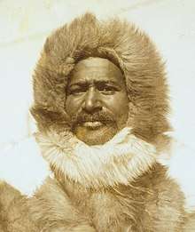
Famous people born in Nanjemoy include Raphael Semmes,[4][5] captain of the Confederate cruiser CSS Alabama, and Matthew Henson,[6][7] with whom Robert Peary explored the Arctic in 1909 and with Peary may have discovered the North Pole.
Wild areas


The Nanjemoy area, on the Atlantic Coastal Plain, includes the largest great blue heron (Ardea herodias) rookery in the Eastern United States north of Florida, now a preserve owned and managed by The Nature Conservancy.[8][9]
The area also includes Purse State Park, well known for its fossil shark teeth, Turritella snails, and other fossils of Paleocene geological age,[10] and other protected wild areas along the Potomac River's freshwater tidal (estuarine) shore. Smallwood State Park, the Chicamuxen Wildlife Management Area, the Doncaster Demonstration Forest and Chapel Point State Park are also nearby.
The Nanjemoy Creek Environmental Education Center, operated by the Charles County Public School system, is located along Nanjemoy Creek. It offers trails, a boardwalk through a freshwater tidal marsh, a pier, a pavilion, a laboratory building, and several cabins for use by school groups.[11] An observatory there, operated by the Southern Maryland Astronomical Society, has a dome formerly used nearby at a U.S. Naval Research Laboratory facility.[12]
Recreation
Hunting and fishing have long been popular in the relatively undeveloped Nanjemoy area, and many miles of remote hiking trails are available. More recently, the area's scenic, little-traveled roads have become popular with cyclists.
Public boat landings are provided on the Potomac at Mallows Bay and on the estuarine portion of Nanjemoy Creek at Friendship Landing, the latter also popular for fishing.[13] Recreational boaters, mostly from the Woodbridge and Quantico areas on the Virginia side of the Potomac, frequently visit the extensive undeveloped river shore in the Purse State Park area. Kayaking is also increasing in popularity in the area, both on the Potomac and on the quiet tidewaters of Nanjemoy Creek.
Notable people
- Raphael Semmes, captain of the Confederate Navy ship CSS Alabama.
- Matthew Henson, Arctic explorer.
References
- "Chickamuxen United Methodist Church". wikimapia.org. Retrieved 13 October 2011.
- The strange voyage of the ghost fleet.The Trust for Public Land, October 28, 2015, retrieved November 21, 2015
- Shomette, Donald G. (Winter 2001). "The Ghost Fleet of Mallows Bay". The Maryland Natural Resource. Archived from the original on April 20, 2011. Retrieved December 19, 2010.
- "Raphael Semmes Connection". Retrieved 2006-11-12.
- "Land Records: Deed Samuel Hanson to Raphael Semmes (1819): Charles County, MD". USGenWeb archives. Archived from the original on December 25, 2005. Retrieved 2006-11-12.
- "Chronology of Henson's life". Retrieved 2006-11-12.
- "Matthew Henson". Maryland State Archives. Retrieved 2006-11-12.
- "Nanjemoy Creek Preserve: A primordial sanctuary for "love birds"". The Nature Conservancy. Archived from the original on 2006-11-11. Retrieved 2006-11-12.
- "Maryland Greenways". Maryland Greenways Commission. Archived from the original on 2006-12-07. Retrieved 2006-11-12.
- "Potomac River". FossilGuy.com. Retrieved 13 October 2011.
- "Nanjemoy Creek Environmental Education Center". Charles County Public Schools. Archived from the original on 14 September 2009. Retrieved 13 October 2011.
- "Nanjemoy Creek Observatory: Frequently asked questions". Southern Maryland Astronomical Society. Archived from the original on 2006-09-23. Retrieved 2006-11-12.
- "Fishing". Nanjemoy.net. Archived from the original on 11 October 2011. Retrieved 13 October 2011.
External links
Municipalities and communities of Charles County, Maryland, United States | ||
|---|---|---|
| Towns | 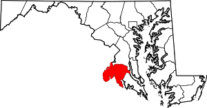 | |
| CDPs | ||
| Other communities | ||
| Authority control |
|
|---|