Prince William County, Virginia
Prince William County is located on the Potomac River in the Commonwealth of Virginia in the United States. As of the 2010 census, the population was 402,002,[2] on July 1, 2019, the population was estimated to be 470,335,[1] making it Virginia's second-most populous county. Its county seat is the independent city of Manassas.[3]
Prince William County | |
|---|---|
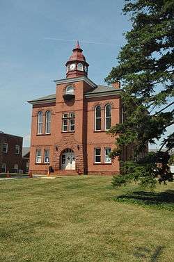
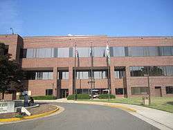 The Prince William County Courthouse in Manassas in July 2011 | |
 Flag  Seal | |
| Nickname(s): "P.W. County" | |
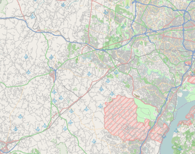
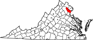 Location within the U.S. state of Virginia | |
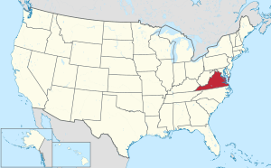 Virginia's location within the U.S. | |
| Coordinates: 38°42′N 77°29′W | |
| Country | |
| State | |
| Founded | 1731 |
| Named for | Prince William, Duke of Cumberland |
| Seat | Manassas |
| Largest town | Dumfries |
| Area | |
| • Total | 348 sq mi (900 km2) |
| • Land | 336 sq mi (870 km2) |
| • Water | 12 sq mi (30 km2) 3.5% |
| Population (2010) | |
| • Total | 402,002 |
| • Estimate (2019)[1] | 470,335 |
| • Density | 1,200/sq mi (450/km2) |
| Time zone | UTC−5 (Eastern) |
| • Summer (DST) | UTC−4 (EDT) |
| Congressional districts | 1st, 10th, 11th |
| Website | www |
A part of Northern Virginia, Prince William County is part of the Washington metropolitan area. In 2019 it had the 20th highest income of any county in the United States.[4]
History
At the time of European colonization, the native tribes of the area that would become Prince William County were the Doeg, an Algonquian-speaking sub-group of the Powhatan tribal confederation. When John Smith and other English explorers ventured to the upper Potomac River beginning in 1608, they recorded the name of a village the Doeg inhabited as Pemacocack (meaning "plenty of fish" in their language). It was located on the west bank of the Potomac River about 30 miles south of present-day Alexandria.[5] Unable to deal with European diseases and firepower, the Doeg abandoned their villages in the area by 1700.[6]
As population increased in the area, Prince William County was created by an act of the General Assembly of the colony of Virginia in 1731; it was organized largely from the western section of Stafford County as well as a section of King George County.[7] The area encompassed by the act creating Prince William County originally included all of what later became the counties of Arlington, Fairfax, Fauquier, and Loudoun; and the independent cities of Alexandria, Fairfax, Falls Church, Manassas, and Manassas Park. These later became independent jurisdictions. The county was named for Prince William, Duke of Cumberland, the third son of King George II.[8]
In 1790 the population of the county was 58% white; most of the remainder were enslaved African Americans. The county had been an area of tobacco plantations, but planters were changing to cultivate mixed crops due to soil exhaustion and changes in the market. In the first two decades after the Revolution, the number and percentage of free blacks increased in Virginia as some whites freed their slaves, based on revolutionary ideals.
Post-Reconstruction era to present
On March 19, 1892, two men, Lee Heflin and Joseph Dye, were lynched in Haymarket. They had been convicted of the murder of a girl and sentenced to death, but the mob did not want to wait for the legal system. The men were hanged from trees at the edge of woods; then the mob shot into their bodies. The Washington Post said, "mob law...is a dangerous thing to encourage. There is too much of it already throughout the country, and it spreads like a contagion so long as public sentiment tacitly approves it."[10] It was unusual that white men were lynched; in Virginia and the rest of the South, black men were overwhelmingly the victims of lynching, the violence by which whites maintained dominance.[11][12][13]
The county was rural and agricultural for decades. Into the early 20th century, the population was concentrated in two areas, one at Manassas (site of a major railroad junction), and the other near Occoquan and Woodbridge along the Potomac River, which was an important transportation route. Beginning in the late 1930s, suburban residential development began and new housing was developed near the existing population centers, particularly in Manassas.
In 1960 the population was 50,164. Continued suburbanization and growth of the Washington, D.C. metropolitan area caused that to increase rapidly in the following decades. There was expansion of federal, military and commercial activities in Northern Virginia in the late 20th century. By 2000, this was the third-most populous local jurisdiction in Virginia. From 2000 to 2010, the population increased by 43.2%. This was the first county in Virginia to be minority-majority: the new majority is composed of Hispanic (of any race, largely of Central and South American ancestry), African American, and Asian.[14] In 2012 it was the seventh-wealthiest county in the country.[15] The estimated population of 2014 is more than 437,000.
In 1994 The Walt Disney Company bought extensive amounts of land in Haymarket for a proposed Disney's America theme park.[16] Local resistance to the resort, because of its perceived adverse effects on the historic Manassas Battlefield, led to its end as a viable idea.[17] William B. Snyder, a local business man convinced Disney to sell the property to him.[18] Snyder, in turn, sold off most of the land to developers, except for the 405 acres (1.64 km2) donated to the National Capital Area Council of the Boy Scouts, who used the land to create Camp Snyder for Cub Scouts.[19]
The Marine Corps Heritage Museum and the Hylton Performing Arts Center opened in the 21st century. The American Wartime Museum is also to be located in this county. During the commemoration of the Sesquicentennial of the Civil War, re-enactment of the famous First and Second Battles of Manassas was planned.
Geography
According to the U.S. Census Bureau, the county has a total area of 348 square miles (900 km2), of which 336 square miles (870 km2) is land and 12 square miles (31 km2) (3.5%) is water.[20] It is bounded on the north by Loudoun and Fairfax Counties; on the west by Fauquier County; on the south by Stafford County; and on the east by the Potomac River (Charles County, Maryland lies across the river).
The Bureau of Economic Analysis combines the independent cities of Manassas and Manassas Park with Prince William County (within which the two cities are enclaves) for statistical purposes:
| Name | Area (km²) | Population 2000 Census | Population 2010 Census | Population July 1, 2018 Estimate |
|---|---|---|---|---|
| Manassas (city) | 25.59 | 35,135 | 37,821 | 41,641 |
| Manassas Park (city) | 6.55 | 10,290 | 14,273 | 17,306 |
| Prince William County | 871.27 | 280,813 | 402,002 | 468,011 |
| Totals | 903.41 | 326,238 | 454,096 | 526,958 |
Adjacent jurisdictions
- Loudoun County – north
- Fairfax County – northeast
- Charles County, Maryland – southeast
- Stafford County – south
- Fauquier County – west
- Manassas – center (enclave)
- Manassas Park – center (enclave)
Government
County Elected Offices
The County is divided into seven magisterial districts: Brentsville, Coles, Potomac, Gainesville, Neabsco, Occoquan, and Woodbridge. The magisterial districts each elect one supervisor to the Board of Supervisors which governs Prince William County. There is also a chairman elected by the county at-large, bringing total board membership to 8. A vice-chairman is selected by the board from among its membership. The county operates under the county form of the county executive system of government, with an elected Board of Supervisors. The board appoints a professional, nonpartisan county executive to manage operations of government agencies.
In other elected County offices, the Prince William County Commonwealth's Attorney, Amy Ashworth, and the Prince William County Clerk of Circuit Court, Jacqueline Smith are Democrats. The Prince William County Sheriff, Glen Hill, is a Republican.
| Name | Party | First Election | District | |
|---|---|---|---|---|
| Ann B. Wheeler, Chairman | Dem | 2019 | At-Large | |
| Jeanine Lawson | Rep | 2015 | Brentsville | |
| Yesli Vega | Rep | 2019 | Coles | |
| Peter Candland | Rep | 2011 | Gainesville | |
| Victor Angry | Dem | 2019 | Neabsco | |
| Kenny A. Boddye | Dem | 2019 | Occoquan | |
| Andrea O. Bailey | Dem | 2019 | Potomac | |
| Margaret Angela Franklin | Dem | 2019 | Woodbridge | |
| Position | Name | Party | First Election | |
|---|---|---|---|---|
| Sheriff | Glendell Hill | Rep | 2003 | |
| Commonwealth's Attorney | Amy Ashworth | Dem | 2019 | |
| Clerk of Circuit Court | Jacqueline Smith | Dem | 2017 | |
State Elected Offices
Republicans formerly held six of the eight Virginia House of Delegates seats that include parts of the county, with that delegation having consisted Robert G. Marshall, Scott Lingamfelter, Tim Hugo, Jackson Miller, Rich Anderson, and Mark Dudenhefer. In the 2017 legislative election, which saw the Democrats cut a Republican majority in the House of Delegates from 66 to 51, Prince William County saw its number of Republican Delegates be reduced from six to one, with Tim Hugo being the sole Republican to represent the county. Marshall, Lingamfelter, Miller, and Anderson all ran for reelection and were defeated by Democratic challengers Danica Roem, Elizabeth Guzmán, Lee Carter, and Hala Ayala respectively. Dudenhefer opted to retire and instead successfully ran for a seat on the Stafford County Board of Supervisors, and he was replaced by Democrat Jennifer Carroll Foy. Democrats Luke Torian and John Bell were already representing the county in the House at the time of the 2017 elections, and with the addition of the five newcomers, Democrats held seven of the eight House seats that include parts of Prince William County. Hugo was then defeated in the 2019 election by Democrat Dan Helmer and Democrats now hold all eight House seats .
Four of the five Virginia State Senate seats that include parts of the county are held by Democrats, including Democratic Sen. Jeremy Mc Pike, the President pro tempore of the Senate, Toddy Puller, George Barker and John Bell. Republican Richard Stuart also represents portions of the county.
In 2005, Democratic Gubernatorial candidate Tim Kaine won the county with 49.95% of the vote.
| Name | Party | First Election | District | |
|---|---|---|---|---|
| Jennifer Carroll Foy | Dem | 2017 | 2 | |
| Danica Roem | Dem | 2017 | 13 | |
| Elizabeth Guzman | Dem | 2017 | 31 | |
| Dan Helmer | Dem | 2019 | 40 | |
| Lee Carter | Dem | 2017 | 50 | |
| Hala Ayala | Dem | 2017 | 51 | |
| Luke Torian | Dem | 2009 | 52 | |
| John Bell | Dem | 2015 | 87 | |
| Name | Party | First Election | District | |
|---|---|---|---|---|
| John Bell | Dem | 2019 | 13 | |
| Richard Stuart | Rep | 2007 | 28 | |
| Jeremy McPike | Dem | 2015 | 29 | |
| Toddy Puller | Dem | 2000 | 36 | |
| George Barker | Dem | 2007 | 39 | |
National politics
Republicans hold one of the three U.S. Congressional seats (VA-1) that include parts of Prince William County. In 2006, Democratic U.S. Senator candidate Jim Webb carried the county with 50.51% of the vote.
In the 2008 United States presidential election, Democrat Barack Obama carried Prince William with 57.51% of the vote, compared to Republican John McCain who received 41.62%. Obama's final rally the night before the election was held at the Prince William County Fairgrounds, just outside the city of Manassas.[21] He was the first Democrat to carry the county since 1964.
Continuing demographic changes in the county, such as an increasingly diverse and urbanized population, were cited by The New York Times as contributing to Obama's success in the 2012 United States presidential election and suggesting the future appeal of the Democratic Party in the United States. Between 2000 and 2010, county population had increased by 121,189 persons (43.2%).[14] It had changed from a primarily white, rural county. Prince William by 2012 had an educated professional population with the seventh-highest income in the country; it is the first county in Virginia to be composed of a majority of minorities: Hispanic, African American, and Asian. Obama and the Democrats attracted their votes.[15] Time identified Prince William as one of five critical counties in Virginia for the election. Obama defeated Romney soundly by 15 percentage points with a margin of 57%–42%,[22] narrowly beating his 2008 margin.
The county continued its trend toward Democratic candidates in the 2016 United States presidential election, Prince William County voted 57.6% for Hillary Clinton to Trump's 36.5%. Clinton's victory represented the largest margin of victory for any presidential candidate in the county since 1988.
| Year | Republican | Democratic | Third parties |
|---|---|---|---|
| 2016 | 36.5% 71,721 | 57.6% 113,144 | 5.9% 11,577 |
| 2012 | 41.3% 74,458 | 57.3% 103,331 | 1.3% 2,406 |
| 2008 | 41.6% 67,621 | 57.5% 93,435 | 0.9% 1,390 |
| 2004 | 52.8% 69,776 | 46.4% 61,271 | 0.8% 1,016 |
| 2000 | 52.5% 52,788 | 44.5% 44,745 | 3.0% 2,978 |
| 1996 | 50.1% 39,292 | 42.7% 33,462 | 7.3% 5,689 |
| 1992 | 46.8% 35,432 | 35.0% 26,486 | 18.2% 13,762 |
| 1988 | 66.7% 39,654 | 32.3% 19,198 | 1.0% 601 |
| 1984 | 68.9% 34,992 | 30.8% 15,631 | 0.4% 180 |
| 1980 | 59.0% 23,061 | 32.7% 12,787 | 8.4% 3,271 |
| 1976 | 49.0% 15,446 | 48.3% 15,215 | 2.7% 863 |
| 1972 | 72.3% 20,149 | 26.1% 7,266 | 1.7% 469 |
| 1968 | 42.5% 7,944 | 29.8% 5,566 | 27.7% 5,176 |
| 1964 | 37.3% 3,343 | 62.6% 5,611 | 0.1% 9 |
| 1960 | 46.5% 2,624 | 53.0% 2,987 | 0.5% 28 |
| 1956 | 51.0% 2,023 | 46.6% 1,851 | 2.4% 96 |
| 1952 | 49.1% 1,619 | 50.2% 1,653 | 0.7% 23 |
| 1948 | 36.5% 760 | 55.8% 1,162 | 7.7% 161 |
| 1944 | 36.2% 763 | 63.6% 1,340 | 0.2% 5 |
| 1940 | 25.8% 500 | 74.0% 1,435 | 0.3% 5 |
| 1936 | 23.1% 457 | 76.3% 1,512 | 0.7% 13 |
| 1932 | 20.2% 386 | 78.6% 1,499 | 1.2% 22 |
| 1928 | 49.7% 817 | 50.3% 826 | |
| 1924 | 23.0% 269 | 72.4% 847 | 4.6% 54 |
| 1920 | 33.3% 393 | 66.5% 786 | 0.3% 3 |
| 1916 | 20.2% 192 | 79.4% 754 | 0.4% 4 |
| 1912 | 8.2% 82 | 81.4% 814 | 10.4% 104 |
Economy
Top employers
According to the County's 2013 Comprehensive Annual Financial Report,[24] the top employers in the county are:
| # | Employer | # of Employees |
|---|---|---|
| 1 | Prince William County Public Schools | 1,000 and over |
| 2 | U.S. Department of Defense | 1,000 and over |
| 3 | Prince William County Government | 1,000 and over |
| 4 | Walmart | 1,000 and over |
| 5 | Morale, Welfare and Recreation | 1,000 and over |
| 6 | Sentara Healthcare | 1,000 and over |
| 7 | Wegmans Food Markets | 500 to 999 |
| 8 | Minnieland Private Day School | 500 to 999 |
| 9 | Northern Virginia Community College | 500 to 999 |
| 10 | Target Corporation | 500 to 999 |
Education
Secondary
Prince William County Public Schools is the second largest school system in Virginia (having recently overtaken Virginia Beach City Public Schools).[25] The system consists of 57 elementary, 16 middle, and 13 high schools, as well as a virtual high school, two traditional schools, three special education schools, and two alternative schools. The Superintendent of Prince William County Public Schools is Dr. Steven L. Walts. The system has a television station called PWCS-TV. It is programmed and operated by Prince William County Public Schools' Media Production Services Department and is accessible to Comcast and Verizon subscribers in Prince William County.
Higher
Demographics
| Historical population | |||
|---|---|---|---|
| Census | Pop. | %± | |
| 1790 | 11,615 | — | |
| 1800 | 12,733 | 9.6% | |
| 1810 | 11,311 | −11.2% | |
| 1820 | 9,419 | −16.7% | |
| 1830 | 9,330 | −0.9% | |
| 1840 | 8,144 | −12.7% | |
| 1850 | 8,129 | −0.2% | |
| 1860 | 8,565 | 5.4% | |
| 1870 | 7,504 | −12.4% | |
| 1880 | 9,180 | 22.3% | |
| 1890 | 9,805 | 6.8% | |
| 1900 | 11,112 | 13.3% | |
| 1910 | 12,026 | 8.2% | |
| 1920 | 13,660 | 13.6% | |
| 1930 | 13,951 | 2.1% | |
| 1940 | 17,738 | 27.1% | |
| 1950 | 22,612 | 27.5% | |
| 1960 | 50,164 | 121.8% | |
| 1970 | 111,102 | 121.5% | |
| 1980 | 144,636 | 30.2% | |
| 1990 | 215,686 | 49.1% | |
| 2000 | 280,813 | 30.2% | |
| 2010 | 402,002 | 43.2% | |
| Est. 2019 | 470,335 | [26] | 17.0% |
| U.S. Decennial Census[27] 1790–1960[28] 1900–1990[29] 1990–2000[30] | |||
As of the census[31] of 2010, there were 402,002 people, 137,115 housing units, and 130,785 households residing in the county. The population density was 1,186 people per square mile (458/km²). There were 137,115 housing units at an average density of 405 per square mile (156/km²). The racial makeup of the county (reporting as only one race) was:
- 57.8% White
- 20.2% Black or African American
- 0.6% Native American
- 7.5% Asian (1.5% Indian, 1.2% Filipino, 1.2% Korean, 0.8% Vietnamese 0.6% Chinese, 0.1% Japanese, 2.1% Other Asian)
- 0.1% Pacific Islander
- 9.1% from other races
- and 5.1% from two or more races
- 20.3% of the population was Hispanic or Latino of any race (6.8% Salvadoran, 3.7% Mexican, 1.8% Puerto Rican, 1.1% Guatemalan, 1.0% Peruvian, 0.9% Honduran, 0.7% Bolivian, 0.4% Colombian, 0.3% Nicaraguan, 0.3% Dominican)
Also according to census figures, there were 130,785 households in Prince William County as of April 1, 2010. According to the Census Bureau's 2009 American Community Survey,[32] 76.1% of the County's households are occupied by families, (compared to 66.5% in the United States). This represents a decrease of 4.6 percentage points since 1990, when 80.7% of households in the County were families. Approximately 42.2% of Prince William County's households are family households occupied by parents with their own children under 18 years of age.
According to the Census Bureau's 2009 American Community Survey, 29.3% of the total County population is under 18 years of age; approximately 6.5% is aged 65 and over. The median age of the population is 33.2 years. The 2009 American Community Survey also indicated that 50.0% of the County's population is male and 50.0% is female.
According to the 2009 American Community Survey, the 2009 median household income in Prince William County was $89,785. The per capita income for the county was $35,890. The 2009 American Community Survey reported that in 2009, 6.0% of Prince William County's population was living below the poverty line, including 7.7% of those under age 18 and 5.3% of those age 65 or over.
It was Virginia's first majority-minority county, with "White, not Hispanic or Latino" at 44.8%, "Hispanic or Latino" at 22.3%, and "Black or African American" at 21.8% the chief groups.[33]
Sports
The Potomac Nationals were a Minor League Baseball team located in Woodbridge, Virginia. The Nationals play in the high-A Carolina League and are an affiliate of the Washington Nationals. The Northern Virginia Royals are an American minor league soccer team, also located in Woodbridge, Virginia. The Royals have minor league affiliation with D.C. United, Washington, D.C. Major League Soccer franchise.
The historic Old Dominion Speedway was located in Manassas. Opened in 1948, it was the location of the first commercial drag race held on the East Coast, and was a stop on the NASCAR Grand National schedule in the late 50s and early 60s. Old Dominion Speedway closed in the Fall of 2012 because of noise complaints.[34]
Museums
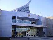
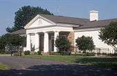
The National Museum of the Marine Corps is located in Triangle, Virginia and is free to the public. The Historic Preservation Division of Prince William County also operates five museums: Rippon Lodge Historic Site, Brentsville Historic Centre, Bristoe Station Battlefield Heritage Park, Lucasville Historic Site, and Ben Lomond Historic Site.
Libraries
The Prince William Public Library System is a regional public library system that serves Prince William County, the City of Manassas and the City of Manassas Park. The system consists of 6 full-service branches and 5 neighborhood branches that covers the entire Prince William area.
Parks
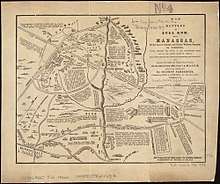
Two National Parks lie within the county. Prince William Forest Park was established as Chopawamsic Recreational Demonstration Area in 1936 and is located in eastern Prince William County. This is the largest protected natural area in the Washington, D.C. metropolitan region at over 15,000 acres (6,070 ha). Manassas National Battlefield Park, located north of Manassas in Prince William County, preserves the site of two major American Civil War battles: the First Battle of Manassas on July 21, 1861, and the Second Battle of Manassas which was fought between August 28 and 30, 1862. Outside the South, these battles are commonly referred to as the first and second battles of Bull Run.
The Prince William County Department of Parks & Recreation operates fifty parks, two water parks, two recreation centers (Birchdale Rec. Center and Sharron Baucom Dale City Rec. Center), two community centers, six sports complexes, and an ice skating rink.
- Prince William Forest Park, the largest National Park Service property in the Washington, D.C. metropolitan area
- Leesylvania State Park, the ancestral home of the Lee family, with a range of recreational activities and views of the river
- Manassas National Battlefield Park, a Civil War battlefield
Transportation
_in_Woodbridge%2C_Prince_William_County%2C_Virginia.jpg)
_in_Gainesville%2C_Prince_William_County%2C_Virginia.jpg)
The county is traversed by many major highways and roads, including the following:


Manassas Regional Airport lies near its namesake city; for commercial passengers, both Dulles Airport and Ronald Reagan Washington National Airport are located nearby.
Public busing in the county is provided by the Potomac and Rappahannock Transportation Commission. Services provided by PRTC include OmniRide, OmniLink, and OmniMatch.
The county is served by both Virginia Railway Express (VRE) lines. The Manassas line has the Manassas Park, Manassas, and Broad Run / Airport stations. The Fredericksburg line has the Woodbridge, Rippon, and Quantico stations.[35] The Manassas, Quantico and Woodbridge stations are also served by Amtrak.
Communities
Census-designated places
Other unincorporated communities
- Aden
- Antioch
- Ashland
- Bethel
- Brentsville
- Bristow
- Buckland
- Canova
- Catharpin
- Cornwell
- Featherstone
- Greenwich
- Hoadly
- Quantico Station
- Rixlew
- Southbridge
- Sudley Springs
- Thoroughfare
- Waterfall
- Wellington
- West Gate
Former communities
- Agnewville
- Batestown
- Groveton
- Hickory Grove
- Hickory Ridge
- Joplin
- Kopp
- Minnieville
- Pamacocack
- Woolsey
Independent cities
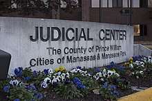
The independent cities of Manassas and Manassas Park are surrounded by Prince William County. Before becoming independent cities in 1975, as are all cities in Virginia, both were towns and officially part of the county. The Prince William County Circuit, District, Juvenile and Domestic Relations Courts, Prince William County Commonwealth Attorney's Office, Prince William County Adult Detention Center, Prince William County Sheriff's Office, and other county agencies are located at Prince William County Courthouse complex. The courthouse complex itself is located in a Prince William County enclave surrounded by the city of Manassas.
Prince William County, Manassas, and Manassas Park share a single judicial system (courts) and Constitutional offices (Commonwealth's Attorney, Sheriff, Circuit Court Clerk).
Notable person
- Austin Steward Abolitionist
Other important features
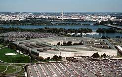
- Marine Corps Base Quantico, a large military installation
- Hylton Performing Arts Center
- Jiffy Lube Live concert venue
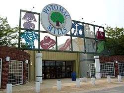
- Potomac Mills, a tourist destination and largest outlet mall in the region
- FBI Academy, the Federal Bureau of Investigation's training and research facility.
- Camp William B. Snyder, one of the largest Cub Scout Camps in the United States.[36]
See also
- National Register of Historic Places listings in Prince William County, Virginia
- Prince William Chamber of Commerce
- Prince William County Police Department
- Prince William County Sheriff's Office
- Prince William Public Library System
- Prince William County Department of Fire and Rescue
- Splash Down Waterpark
References
- "County Population Totals and Components of Change: 2010-2018". Retrieved May 25, 2019.
- "State & County QuickFacts". United States Census Bureau. Archived from the original on July 17, 2011. Retrieved January 4, 2014.
- "Find a County". National Association of Counties. Retrieved June 7, 2011.
- "The 20 wealthiest counties in the U.S., including these Washington, DC, suburbs: Report". Foxbusiness.com. Retrieved February 20, 2020.
- Swanton, John R. (1952), The Indian Tribes of North America, Smithsonian Institution, p. 69, ISBN 0-8063-1730-2, OCLC 52230544
- Brown, George (1991). "The Indians And the Collision of Cultures". Historicprincewilliam.org. Historic Prince William, Inc. Archived from the original on November 17, 2016. Retrieved December 19, 2016.
- "Legislation creating Prince William County, Virginia". Historic Prince William. Archived from the original on April 22, 2000. Retrieved September 20, 2008.
- "Commemorating the 275th anniversary of Prince William County, Virginia". Sunlight Foundation. Archived from the original on March 17, 2014. Retrieved May 5, 2012.
- Bamberger, Shelomoh, ha-Le?vi, Waters-Son, and West & Johnston. "Map of battles on Bull Run, near Manassas, on the line of Fairfax & Prince William Counties, in Virginia, fought between the forces of the Confederate States and of the United States of America." Map. 1861. Norman B. Leventhal Map Center, https://collections.leventhalmap.org/search/commonwealth:xg94j217q (accessed June 26, 2017).
- "Swifter than the Law," Washington Post, March 19, 1892, p.1
- W. Fitzhugh Brundage, Lynching in the New South: Georgia and Virginia (Chicago: University of Illinois Press, 1993), 87-92
- "Mob Carries Out Death Sentence", History Engine, University of Richmond, 2008-2015
- "Killing Grounds Lynchings re: Haymarket", Washington Post, July 24, 2005; accessed March 16, 2018
- "Demographic and Economic Newsletter" Archived September 24, 2015, at the Wayback Machine, Prince William Report, Second Quarter 2014, April–June 2014
- Michael D. Shear (November 7, 2012). "Demographic Shift Brings New Worry for Republicans". The New York Times. Retrieved November 8, 2012.
- Wines, Michael (November 12, 1993). "A Disneyland of History Next to the Real Thing". The New York Times. ISSN 0362-4331. Retrieved May 8, 2016.
- Powell, Elizabeth A.; Stover, Sarah (July 26, 2010). The Third Battle of Bull Run: The Disney's America Theme Park (A). Charlottesville. pp. 1–19. ProQuest 872767379.
- The Disney Drawing Board – Disney’s America Archived September 20, 2016, at the Wayback Machine retrieved October 30, 2013.
- Stewart, Nikita (April 5, 2006). "$17 Million Camp Pledges Cub Scout Nirvana in Va.: [FINAL Edition]". The Washington Post. Washington, D.C., United States. pp. –01. ISSN 0190-8286. ProQuest 410008043.
- "US Gazetteer files: 2010, 2000, and 1990". United States Census Bureau. February 12, 2011. Retrieved April 23, 2011.
- Kiser, Uriah (November 1, 2008). "Thousands gathering for Obama's final rally". insidenova.com. Archived from the original on December 6, 2008. Retrieved February 18, 2010.
- "The White House – Obama's Path to Victory", Time, pp. 16–17, November 19, 2012
- Leip, David. "Dave Leip's Atlas of U.S. Presidential Elections". uselectionatlas.org.
- "Comprehensive Annual Financial Report for the Fiscal Year Ended June 30, 2013" (PDF). County of Prince William, Virginia.
- "Northern Virginia rises to dominance". The Virginian-Pilot. Norfolk, Virginia. December 31, 2007. Retrieved September 20, 2008.
- "Population and Housing Unit Estimates". Retrieved March 26, 2020.
- "U.S. Decennial Census". United States Census Bureau. Retrieved January 2, 2014.
- "Historical Census Browser". University of Virginia Library. Retrieved January 2, 2014.
- "Population of Counties by Decennial Census: 1900 to 1990". United States Census Bureau. Retrieved January 2, 2014.
- "Census 2000 PHC-T-4. Ranking Tables for Counties: 1990 and 2000" (PDF). United States Census Bureau. Retrieved January 2, 2014.
- "U.S. Census website". United States Census Bureau. Retrieved May 14, 2011.
- American Community Survey, US Census Bureau, archived from the original on February 12, 2020, retrieved June 22, 2011
- US Census Bureau. "QuickFacts Prince William County, Virginia". U.S. Department of Commerce.
White alone, not Hispanic or Latino, percent, July 1, 2015, (V2015) 44.8%, Hispanic or Latino, percent, July 1, 2015, (V2015) 22.3%. Black or African American alone, percent, July 1, 2015, (V2015) 21.8%, Asian alone, percent, July 1, 2015, (V2015) 8.7%, Two or More Races, percent, July 1, 2015, (V2015) 4.4%, American Indian and Alaska Native alone, percent, July 1, 2015, (V2015) 1.1%, Native Hawaiian and Other Pacific Islander alone, percent, July 1, 2015, (V2015) 0.2% The vintage year (e.g., V2015) refers to the final year of the series (2010 thru 2015).
- "Old Dominion Speedway plans to relocate to Spotsylvania County". Business Insider. Archived from the original on February 21, 2013.
- Station Map, Virginia Railway Express (VRE), archived from the original on August 10, 2009, retrieved August 9, 2009
- Weimar, Carrie (May 1, 2006). "For his devotion, a Scouts honor". St. Petersburg Times. St. Petersburg, FL. Retrieved June 14, 2016.
External links
| Wikimedia Commons has media related to Prince William County, Virginia. |

- Official website
- Prince William County at the Wayback Machine (archived June 7, 2012)
- Prince William County at the Wayback Machine (archived April 12, 1997)
Places adjacent to Prince William County, Virginia | ||||||||||
|---|---|---|---|---|---|---|---|---|---|---|
| ||||||||||
| |||||
| Administration |
| | |||
| Organizations | |||||
| Landmarks |
| ||||
| Transportation |
| ||||
| Culture |
| ||||
| Education | |||||
Municipalities and communities of Prince William County, Virginia, United States | ||
|---|---|---|
| Towns | Map of Virginia highlighting Prince William County | |
| CDPs | ||
| Unincorporated communities | ||
| Footnotes | ‡This populated place also has portions in an adjacent county or counties | |
| Principal cities (and city-like entities) |
|   | |||||||
|---|---|---|---|---|---|---|---|---|---|
| Counties (and county equivalents) |
| ||||||||
The District of Columbia itself, and Virginia's incorporated cities, are county equivalents. Virginia's incorporated cities are listed under their surrounding county. The incorporated cities bordering more than one county (Alexandria, Falls Church and Fredericksburg) are listed under the county they were part of before incorporation as a city. Some unincorporated areas and census-designated places like Silver Spring and Bethesda in Maryland, Reston in Virginia, as well as the County of Arlington in Virginia are also treated as city-like entities (or principal cities) even though they have not been legally incorporated as such. | |||||||||
| Authority control |
|
|---|