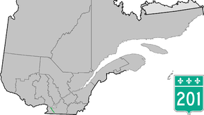
Quebec Route 201
Route 201 is a north/south provincial highway within the Canadian province of Quebec, running between Route 202 in Franklin (near the Canada–US border) and Route 342 in Rigaud. Its total length is approximately 70 kilometres.
| ||||
|---|---|---|---|---|
 | ||||
| Route information | ||||
| Maintained by Transports Québec | ||||
| Length | 69.8 km[1] (43.4 mi) | |||
| Major junctions | ||||
| South end | ||||
| North end | ||||
| Location | ||||
| Counties | Le Haut-Saint-Laurent / Beauharnois-Salaberry / Vaudreuil-Soulanges | |||
| Highway system | ||||
| ||||

Route 201 links Salaberry-de-Valleyfield with Autoroute 20 using the Monseigneur Langlois Bridge to cross the Saint Lawrence River. It is among the four primary or secondary highways to cross the Saint Lawrence River and is the only 200 series highway to be partly north of that river.
Municipalities along Route 201
South end of Quebec Route 201
- Franklin
- Ormstown
- Saint-Stanislas-de-Kostka
- Salaberry-de-Valleyfield
- Coteau-du-Lac
- Saint-Clet
- Saint-Lazare
- Sainte-Marthe
- Rigaud
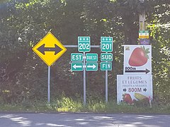
- Southern end at route 202.
.jpg) Intersection with Route 132 in Saint-Stanislas.
Intersection with Route 132 in Saint-Stanislas..jpg) Route 201 is concurrent with Route 132 and Autoroute 530.
Route 201 is concurrent with Route 132 and Autoroute 530..jpg) Route 201 in Valleyfield.
Route 201 in Valleyfield.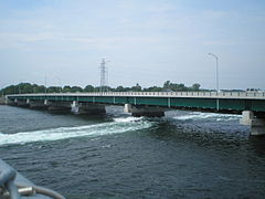 Monseigneur-Langlois Bridge between Valleyfield and Coteau-du-Lac.
.jpg) Interchange with Autoroute 20.
Interchange with Autoroute 20.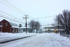 Junction of 340 and 201 in Saint-Clet.
Major intersections
| RCM or ET | Municipality | Km | Junction | Notes |
|---|---|---|---|---|
Southern terminus of Route 201 | ||||
| Le Haut-Saint-Laurent | Franklin | 0.0 | 202 WEST: to Hinchinbrooke 202 EAST: to Havelock | |
| 2.4 | 209 SOUTH: to Franklin County, New York 209 NORTH: to Saint-Chrysostome | |||
| Ormstown | 13.6 14.8 |
138 EAST: to Très-Saint-Sacrement 138 WEST: to Godmanchester | ||
| Beauharnois-Salaberry | Saint-Stanislas-de-Kostka | 23.8 | 236 WEST: to Saint-Stanislas-de-Kostka 236 EAST: to Saint-Louis-de-Gonzague | |
| 29.6 | 132 WEST: to Sainte-Barbe | |||
| Salaberry-de-Valleyfield | 31.6 | West end of Autoroute 530 | ||
| Salaberry-de-Valleyfield (Saint-Timothée) |
36.5 | 530 EAST: to Saint-Timothée (Salaberry-de-Valleyfield) | ||
| Salaberry-de-Valleyfield (Grande-Île) |
37.5 | 132 EAST: to Beauharnois | ||
| Vaudreuil-Soulanges | Coteau-du-Lac | 45.8 46.1 |
338 EAST: to Les Cèdres 338 WEST: to Les Coteaux | |
| 49.7 50.0 |
20 EAST: to Les Cèdres 20 WEST: to Les Coteaux | |||
| Saint-Clet | 56.7 | 340 WEST: to Saint-Polycarpe 340 EAST: to Saint-Lazare | ||
| Rigaud | 69.3 69.4 |
40 EAST: to Vaudreuil-Dorion 40 WEST: to Pointe-Fortune | ||
| 69.8 | 342 WEST: to Pointe-Fortune 342 EAST: to Hudson | |||
Northern terminus of Route 201 | ||||
gollark: They're also basically entirely funded by Google.
gollark: OOP is a disadvantage, actually.
gollark: Try being in a different industry.
gollark: Low-core-count x86 CPUs apparently use some kind of ring bus interconnect.
gollark: They do charge for it.
See also
References
- Ministère des transports, "Distances routières", page 79, Les Publications du Québec, 2005
External links
- Route 201 on Google Maps
- Official Transport Quebec Road Map (Courtesy of the Quebec Ministry of Transportation) (in French)
This article is issued from Wikipedia. The text is licensed under Creative Commons - Attribution - Sharealike. Additional terms may apply for the media files.