Quebec Route 199
Route 199 is an 85 km (53 mi) north–south highway located on the Magdalen Islands, in the Gulf of Saint Lawrence. Stretching from Les Îles-de-la-Madeleine's communities of L'Île-du-Havre-Aubert to Grande-Entrée, the route is the main artery of the archipelago and is the only Quebec numbered highway that is detached from the rest of the network.
| ||||
|---|---|---|---|---|
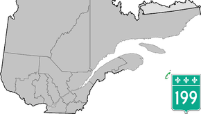 | ||||
| Route information | ||||
| Maintained by Transports Québec | ||||
| Length | 84.7 km[1] (52.6 mi) | |||
| Major junctions | ||||
| South end | in Les Îles-de-la-Madeleine (L'Île-du-Havre-Aubert) | |||
| North end | in Les Îles-de-la-Madeleine (Grande-Entrée) | |||
| Location | ||||
| Major cities | Les Îles-de-la-Madeleine, Grosse-Île | |||
| Highway system | ||||
| ||||

Municipalities along Route 199
- Les Îles-de-la-Madeleine - (L'Île-du-Havre-Aubert / L'Étang-du-Nord / Cap-aux-Meules / Fatima / Havre-aux-Maisons / Pointe-aux-Loups / Grande-Entrée)
- Grosse-Île
gollark: I know the answer, of course.
gollark: Oh, wait.
gollark: And I'm jan Nonsen.
gollark: And yet #6 is *my* entry.
gollark: Ah, I see.
See also
References
- Ministère des transports, "Distances routières", page 77, Les Publications du Québec, 2005
External links
- Provincial Route Map (Courtesy of the Quebec Ministry of Transportation) (in French)
- Route 199 on Google Maps
This article is issued from Wikipedia. The text is licensed under Creative Commons - Attribution - Sharealike. Additional terms may apply for the media files.