Quebec Route 287
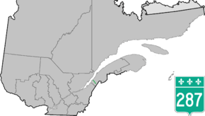
Route 287 is a 42 km two-lane north/south highway on the south shore of the Saint Lawrence River in the Bas-Saint-Laurent region of Eastern Quebec, Canada. Its northern terminus is in Saint-Denis at the junction of Route 132 and the southern terminus is at Lac de l'Est, part of the municipality of Mont-Carmel. About 10 km after Mont-Carmel, the route becomes a gravel road until the lake.
| ||||
|---|---|---|---|---|
 | ||||
| Route information | ||||
| Length | 42.0 km[1] (26.1 mi) | |||
| Major junctions | ||||
| South end | Rue des Trembles / Rue des Epinettes south of Mont-Carmel | |||
| North end | ||||
| Location | ||||
| Major cities | Saint-Philippe-de-Neri | |||
| Highway system | ||||
| ||||

List of towns along Route 287
- Saint-Denis
- Saint-Philippe-de-Neri
- Mont-Carmel
gollark: And you don't have anything worthy of my attention.
gollark: People can mute your pings or just leave.
gollark: It does not get attention.
gollark: How do you plan to provide O2 self-sustainingly?
gollark: Also redundant life support.
See also
References
- Ministère des transports, "Distances routières", page (?), Les Publications du Québec, 2005
External links
- Provincial Route Map (Courtesy of the Quebec Ministry of Transportation) (in French)
- Route 287 on Google Maps
This article is issued from Wikipedia. The text is licensed under Creative Commons - Attribution - Sharealike. Additional terms may apply for the media files.