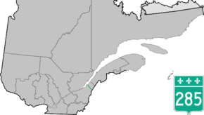
Quebec Route 285
Route 285 is a 48 km two-lane north/south highway on the south shore of the Saint Lawrence River in the Chaudière-Appalaches region of Quebec, Canada. Its northern terminus is in L'Islet at the junction of Route 132 and the southern terminus is close to Saint-Adalbert at the junction of Route 204.
| ||||
|---|---|---|---|---|
 | ||||
| Route information | ||||
| Length | 48.0 km[1] (29.8 mi) | |||
| Major junctions | ||||
| South end | ||||
| North end | ||||
| Location | ||||
| Major cities | L'Islet | |||
| Highway system | ||||
| ||||

Towns along Route 285
.jpg) Quebec Route 285 near Saint-Adalbert.
Quebec Route 285 near Saint-Adalbert.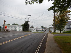 Route 285 in Saint-Cyrille-de-Lessard.
 Route 285 south of Saint-Cyrille.
gollark: Oh, so potatOS is non-stupid? Yay, you finally admit it.
gollark: It only works on nonexistent functions.
gollark: __index won't work.
gollark: ```osmarks@tyr ~> wscat -c wss://osmarks.tk/skynet/connectconnected (press CTRL+C to quit)> ```*accesses skynet*
gollark: Or usability reasons.
See also
References
- Ministère des transports, "Distances routières", page (?), Les Publications du Québec, 2005
External links
- Provincial Route Map (Courtesy of the Quebec Ministry of Transportation) (in French)
- Route 285 on Google Maps
This article is issued from Wikipedia. The text is licensed under Creative Commons - Attribution - Sharealike. Additional terms may apply for the media files.