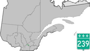
Quebec Route 239
Route 239 is a north/south highway on the south shore of the Saint Lawrence River. Its northern terminus is at Route 133 in Sainte-Victoire-de-Sorel and its southern terminus is at Saint-Germain-de-Grantham at the junction of Route 122.
| ||||
|---|---|---|---|---|
 | ||||
| Route information | ||||
| Maintained by Transports Québec | ||||
| Length | 63.3 km[1] (39.3 mi) | |||
| Major junctions | ||||
| South end | ||||
| North end | ||||
| Highway system | ||||
| ||||

Municipalities along Route 239
- Saint-Germain-de-Grantham
- Saint-Eugène
- Saint-Guillaume
- Saint-Marcel-de-Richelieu
- Massueville
- Sainte-Victoire-de-Sorel
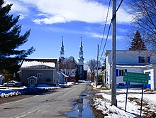
Approaching the intersection of Route 239 (rang de l'Église) and Route des Loisirs in Saint-Eugène.
gollark: They should also invest in foreign currencies or something, I guess.
gollark: Idea: buy raw materials and make counterfeit coins! What COULD go wrong.
gollark: Plus you get much more of them.
gollark: Hmm. Perhaps.
gollark: Potential to do what, lose money?
See also
References
- Ministère des transports, "Distances routières", page 87, Les Publications du Québec, 2005
External links
- Route 239 on Google Maps
- Provincial Route Map (Courtesy of the Quebec Ministry of Transportation) (in French)
This article is issued from Wikipedia. The text is licensed under Creative Commons - Attribution - Sharealike. Additional terms may apply for the media files.