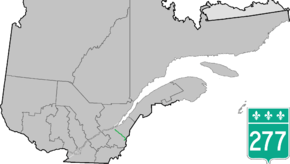
Quebec Route 277
Route 277 is a two-lane north/south highway in the Chaudière-Appalaches region in the province of Quebec, Canada. Its northern terminus is in Saint-Henri at the junction of Route 173 and its southern terminus is in Sainte-Aurélie at the junction of Route 275.
| ||||
|---|---|---|---|---|
 | ||||
| Route information | ||||
| Length | 101.0 km[1] (62.8 mi) | |||
| Major junctions | ||||
| South end | ||||
| North end | ||||
| Location | ||||
| Major cities | Saint-Henri-de-Levis, Lac-Etchemin, Saint-Louis-de-Gonzague | |||
| Highway system | ||||
| ||||

Towns along Route 277
- Saint-Henri-de-Levis
- Saint-Anselme
- Sainte-Claire
- Saint-Malachie
- Saint-Leon de Standon
- Lac-Etchemin
- Sainte-Rose-de-Watford
- Saint-Louis-de-Gonzague
- Sainte-Aurélie
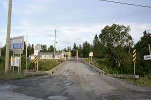 United States port of entry right off Route 277 in Sainte-Aurélie.
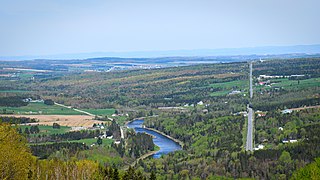 Route 277 along Etchemin River in Saint-Malachie.
gollark: Just copy and paste code from Botania.
gollark: I can do OC/CC GUIs (kind of) at least, definitely not Minecraft's-probably-crazy-GUI-framework ones.
gollark: UIs are evil, you see.
gollark: As in, yes I also hate making them.
gollark: Yes.
See also
References
- Ministère des transports, "Distances routières", page (?), Les Publications du Québec, 2005
External links
- Provincial Route Map (Courtesy of the Quebec Ministry of Transportation) (in French)
- Route 277 on Google Maps
This article is issued from Wikipedia. The text is licensed under Creative Commons - Attribution - Sharealike. Additional terms may apply for the media files.