Ormstown, Quebec
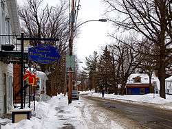
Ormstown is a municipality in Quebec, Canada, which is situated on the Chateauguay River in the heart of the Chateauguay Valley. It is approximately one hour southwest of Montreal and 20 minutes north of New York State in the United States. The population as of the Canada 2011 Census was 3,595 of which Francophones comprise about 65%.
Ormstown | |
|---|---|
Municipality | |
 | |
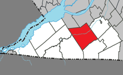 Location within Le Haut-Saint-Laurent RCM | |
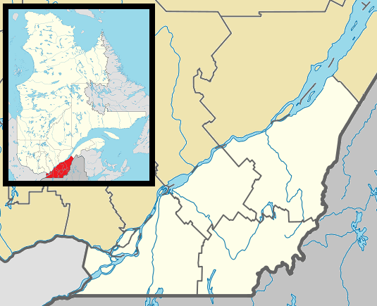 Ormstown Location in southern Quebec | |
| Coordinates: 45°08′N 74°00′W[1] | |
| Country | |
| Province | |
| Region | Montérégie |
| RCM | Le Haut-Saint-Laurent |
| Constituted | January 26, 2000 |
| Government | |
| • Mayor | Chrystian Soucy |
| • Federal riding | Salaberry—Suroît |
| • Prov. riding | Huntingdon |
| Area | |
| • Total | 144.50 km2 (55.79 sq mi) |
| • Land | 142.79 km2 (55.13 sq mi) |
| Population (2016)[4] | |
| • Total | 3,595 |
| • Density | 25.2/km2 (65/sq mi) |
| • Pop 2011-2016 | |
| • Dwellings | 1,641 |
| Time zone | UTC−5 (EST) |
| • Summer (DST) | UTC−4 (EDT) |
| Postal code(s) | J0S 1K0 |
| Area code(s) | 450 and 579 |
| Highways | |
| Website | www |
Ormstown has two elementary schools, one high school (Chateauguay Valley Regional), and two adult education facilities, several restaurants and churches. Ormstown is also well known for its numerous antique dealers and unique gift shops. There is a park north of the centre of town which is home to Ormstown Beach, an urban legend created and memorialized in the 1970s with "I've been to Ormstown Beach" bumper stickers. It is a popular summer activity to cycle along the Chateauguay River. The town has traces of an old dam, which was once the source of power for the mill. People living outside the town only gained access to electricity following World War II.
History
In the 1950s, Ormstown became the site of a significant microwave radio relay station, part of the Trans Canada Telephone System. Initially, the system passed through the major cities of Canada via towers located on top of downtown telephone buildings. Subsequently, concerns were expressed that a disaster affecting any of those city cores, such as a war or uprising, would result in an interruption of the continuity of the transcontinental communications system. The solution was to locate a "bypass" microwave site outside each of those cities with links to the east and west, as well as a short link into the city. The Ormstown facility was the bypass point for Montreal, but had further significance as it also included a link to the AT&T Long Lines TD2 microwave system in the United States.
In 2000, the town merged with the surrounding parish of St-Malachie d'Ormstown to form the Municipality of Ormstown.[5]
Geography
Communities
The following locations reside within the municipality's boundaries:[1]
- Tatehurst (45°08′32″N 74°00′54″W) – a hamlet located in the northern portion along Route 201.
Lakes & Rivers
The following waterways pass through or are situated within the municipality's boundaries:[1]
- Étang Greig (Greig Pond) (45°07′03″N 73°54′19″W) – a pond in the eastern portion.
- Rivière aux Outardes (Outardes River) (Mouth 45°07′21″N 74°00′11″W) – feeds into the Chateauguay River (la Rivière Chateauguay).
- Rivière aux Outardes Est (East Outardes River) (Mouth 45°06′01″N 74°03′54″W) – feeds into Rivière aux Outardes.
- Chateauguay River – flows west to east through the municipality.
Demographics
Population
| Canada census – Ormstown, Quebec community profile | |||
|---|---|---|---|
| 2011 | 2006 | ||
| Population: | 3,595 (-1.5% from 2006) | 3,651 (+0.1% from 2001) | |
| Land area: | 142.19 km2 (54.90 sq mi) | 141.72 km2 (54.72 sq mi) | |
| Population density: | 25.3/km2 (66/sq mi) | 25.8/km2 (67/sq mi) | |
| Median age: | 47.0 (M: 45.6, F: 47.7) | 44.6 (M: 44.2, F: 44.9) | |
| Total private dwellings: | 1,516 | 1,522 | |
| Median household income: | $.N/A | $39,042 | |
| Notes: 2011 income data for this area has been suppressed for data quality or confidentiality reasons. – References: 2011[6] 2006[7] earlier[8] | |||
|
| |||||||||||||||||||||||||||
(+) Amalgamated with Saint-Malachie-d'Ormstown in 2000. | ||||||||||||||||||||||||||||
Language
| Canada Census Mother Tongue - Ormstown, Quebec[9] | ||||||||||||||||||
|---|---|---|---|---|---|---|---|---|---|---|---|---|---|---|---|---|---|---|
| Census | Total | French |
English |
French & English |
Other | |||||||||||||
| Year | Responses | Count | Trend | Pop % | Count | Trend | Pop % | Count | Trend | Pop % | Count | Trend | Pop % | |||||
2016 |
3,465 |
2,145 | 61.90% | 1,160 | 33.48% | 75 | 2.16% | 70 | 2.02% | |||||||||
2011 |
3,495 |
2,160 | 61.80% | 1,205 | 34.48% | 65 | 1.86% | 65 | 1.86% | |||||||||
2006 |
3,530 |
2,220 | 62.89% | 1,205 | 34.13% | 50 | 1.42% | 55 | 1.56% | |||||||||
2001 |
3,535 |
2,245 | 63.51% | 1,170 | 33.10% | 50 | 1.41% | 70 | 1.98% | |||||||||
1996 |
1,505 |
890 | n/a | 59.14% | 575 | n/a | 38.21% | 30 | n/a | 1.99% | 10 | n/a | 0.66% | |||||
Attractions
Expo Ormstown
One of the town's main attractions is the Expo Ormstown -- formally known as the Ormstown Fair -- which was started in 1910. It is held annually during the second week of June, making it Quebec's earliest spring fair. Several competitions take place at the fair: farm animals, crafts, horticulture and baked goods are evaluated by judges and can be viewed by fair goers. Other competitions include a tractor pull, demolition derby, and equestrian events. Additionally, there are carnival rides, arcades, a petting zoo, and live musical performances. The Ormstown fair attracts people from all surrounding areas.
Allan's Corners
Located near Ormstown, in the hamlet of Allan's Corners, is the site of the Battle of the Chateauguay, where on October 26, 1813 Canadian and Native forces fought and repelled an invading American force that was planning to attack Montreal during the War of 1812. The site is a National Historic Site of Canada,[10] and there is a Parks Canada museum near the site of the battle.
Government
Jacques Lapierre was elected to fill the post of mayor on November 1, 2009, replacing interim mayor Luc Lavigueur. Lavigueur took over the post after former mayor John McCaig resigned for health reasons.
Infrastructure
Transportation
The CIT du Haut-Saint-Laurent provides commuter and local bus services.
See also
- Le Haut-Saint-Laurent Regional County Municipality
- Chateauguay River
- Rivière aux Outardes (Chateauguay River)
- Rivière aux Outardes Est
- List of municipalities in Quebec
- Vladimir Katriuk
References
- Reference number 358447 of the Commission de toponymie du Québec (in French)
- Ministère des Affaires municipales, des Régions et de l'Occupation du territoire: Ormstown
- Riding history for Beauharnois—Salaberry, Quebec from the Library of Parliament
- 2011 Statistics Canada Census Profile: Ormstown, Quebec
- www.rootsweb.com
- "2011 Community Profiles". 2011 Canadian Census. Statistics Canada. July 5, 2013. Retrieved 2014-02-10.
- "2006 Community Profiles". 2006 Canadian Census. Statistics Canada. March 30, 2011. Retrieved 2014-02-10.
- "2001 Community Profiles". 2001 Canadian Census. Statistics Canada. February 17, 2012.
- Statistics Canada: 1996, 2001, 2006, 2011 census
- Battle of the Chateauguay. Canadian Register of Historic Places. Retrieved 4 March 2012.
External links
| Wikimedia Commons has media related to Ormstown. |
Adjacent Municipal Subdivisions | ||||||||||
|---|---|---|---|---|---|---|---|---|---|---|
| ||||||||||
| Cities | |
|---|---|
| Municipalities | |
| Parishes |
|
| Townships | |
| |