Quebec Route 275
Route 275 is a two-lane north/south highway in the Chaudière-Appalaches region in the province of Quebec. Its northern terminus is in Saint-Romuald, now part of Lévis at the junction of Route 132 and its southern terminus is in Saint-Côme–Linière at the junction of Route 173.
| ||||
|---|---|---|---|---|
 | ||||
| Route information | ||||
| Length | 132.0 km[1] (82.0 mi) | |||
| Major junctions | ||||
| South end | ||||
| North end | ||||
| Location | ||||
| Major cities | Saint-Romuald (Lévis), Saint-Jean-Chrysostome (Lévis), Saint-Côme–Linière | |||
| Highway system | ||||
| ||||

Towns along Route 275
.jpg)
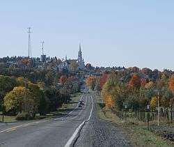
Quebec Route 275 in Saint-Isidore
- Saint-Côme–Linière
- Saint-Zacharie
- Saint-Prosper
- Saint-Benjamin
- Saint-Odilon-de-Cranbourne
- Sainte-Marguerite
- Sainte-Hénédine
- Saint-Isidore
- Saint-Jean-Chrysostome (Lévis)
- Saint-Romuald (Lévis)
 Entering Saint-Prosper.
 Route 275 through Saint-Odilon describes a straight line over hills and valleys.
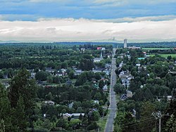 Route 275 in Frampton.
gollark: I agree entirely, gollarioid.
gollark: ++tel link apionet `#g`
gollark: Do so then.
gollark: No. I can't add bots on my phone due to thing.
gollark: ABR is antimemetic/nonexistent.
See also
References
- Ministère des transports, "Distances routières", page (?), Les Publications du Québec, 2005
External links
- Route 273 on Google Maps
- Provincial Route Map (Courtesy of the Quebec Ministry of Transportation) (in French)
This article is issued from Wikipedia. The text is licensed under Creative Commons - Attribution - Sharealike. Additional terms may apply for the media files.