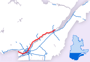
Quebec Autoroute 40
Autoroute 40, officially known as Autoroute Félix-Leclerc outside Montreal and Metropolitan Autoroute/Autoroute Métropolitaine within Montreal, is an Autoroute on the north shore of the St. Lawrence River in the Canadian province of Quebec. It is one of the two major connections between Montreal and Quebec City, the other being Autoroute 20 on the south shore of the St. Lawrence. Autoroute 40 is currently 347 km (215.6 mi) long. Between the Ontario–Quebec boundary and the interchange with Autoroute 25, the route is signed as part of the Trans-Canada Highway.
| ||||
|---|---|---|---|---|
| Autoroute Félix-Leclerc Metropolitan Expressway Trans-Canada Highway | ||||
 | ||||
| Route information | ||||
| Maintained by Transports Québec | ||||
| Length | 347 km[1][2] (216 mi) | |||
| Existed | 1959[3]–present | |||
| Major junctions | ||||
| West end | ||||
| ||||
| East end | ||||
| Location | ||||
| Major cities | Vaudreuil-Dorion, Dollard-des-Ormeaux, Pointe-Claire, Montreal, Terrebonne, Charlemagne, Repentigny, Trois-Rivières, Quebec City | |||
| Highway system | ||||
| ||||

Route description
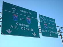
The western terminus of Autoroute 40 is located at the Ontario–Quebec border, where it continues as Highway 417 towards Ottawa; the eastern terminus is in Boischatel, where it transitions into Route 138 at the end of the freeway.
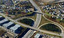
The portion of Autoroute 40 from the Ontario border to Autoroute 25 is part of the Trans-Canada Highway. The Metropolitan Autoroute portion in Montreal is the busiest highway in Quebec, the busiest section of the Trans-Canada Highway, as well as the second busiest highway section overall in Canada after Highway 401 in Toronto.
History
Two sections of Autoroute 40 were not part of the original plans: The original intention was to bypass Trois-Rivières to the north (the existing A-40 through downtown would have been Autoroute 755 and the concurrency with Autoroute 55 would have been simply A-55). In addition, a different route was originally planned around Sainte-Foy (now in the west end of Quebec City) south of Jean Lesage International Airport (the existing 12 km (7 mi) segment of Autoroute 40 between St-Augustin and Autoroute 73 would have been the western end of Autoroute 440, thus explaining the exit numbering starting at 12). While the right-of-ways of both bypasses still exist and may still be developed in the future as congestion increases, there are no immediate plans to renew construction.
Some discussion of eastward extensions of A-40 into the Charlevoix region and beyond have taken place, most likely to Route 360 in Beaupré or even as far as Route 362 in La Malbaie since tourism in the region is increasing; however, that appears unlikely in the short term.
A 25 km (16 mi) stretch of the highway in Pointe-Claire, from roughly St. John's Boulevard, near Fairview Pointe-Claire Shopping Centre, to the turnaround loop, Senneville Road was used during the 1976 Summer Olympics for the men's road team time trial cycling race.[4]
_-_Est.JPG)
In 1997, the highway (apart from the portion served by the Metropolitan Autoroute) was renamed Autoroute Félix-Leclerc after the late Quebec artist and political activist Félix Leclerc.
Prior to 1997, Autoroute 40 east of Montreal had four different names, the first section was named Autoroute de la Rive-Nord (North Shore Autoroute) between Montréal and Saint-Augustin-de-Desmaures (km 87 to 196, 209 to 296). A segment in Trois-Rivières east of Autoroute 55 that was named Autoroute de Francheville (Francheville Autoroute) (km 196 to 207). Between Saint-Augustin and Autoroute 73 in Quebec City (km 296 to 307) it was called Autoroute Charest. Finally, between the junction of Autoroute 73 and Autoroute 573 and its eastern end at Route 138 it was known as Autoroute de la Capitale, a name that is still commonly used by Quebec City residents.
Exit list
| RCM | Location | km[1] | mi | Exit | Destinations | Notes | |
|---|---|---|---|---|---|---|---|
| Quebec / Ontario boundary | 0.0 | 0.0 | Continues as | ||||
| Montérégie | Pointe-Fortune | 1 | Straddles the Ontario border; also signed as Exit 1 for Hwy 417. | ||||
| Pointe-Fortune – Rigaud boundary | 2.7 | 1.7 | 2 | Montée Wilson – Pointe-Fortune | |||
| Rigaud | 6.2 | 3.9 | 6 | Montée de la Baie-Saint-Thomas | |||
| 9.4 | 5.8 | 9 | |||||
| 11.8 | 7.3 | 12 | |||||
| 16.9 | 10.5 | 17 | |||||
| Saint-Lazare | 22.0 | 13.7 | 22 | Hudson, Saint-Lazare | |||
| Vaudreuil-Dorion | 26.5 | 16.5 | 26 | Eastbound access to Route 342 | |||
| 27.5 | 17.1 | 28 | Westbound exit, eastbound entrance | ||||
| 32.6 | 20.3 | 32 | Exit 1 on A-30; former A-540 | ||||
| 34.7 | 21.6 | 35 | Avenue Saint-Charles – Vaudreuil-Dorion, Vaudreuil-sur-le-Lac | ||||
| 36.6 | 22.7 | 36 | Chemin Dumberry, Chemin des Chenaux | Westbound exit, eastbound entrance | |||
| Lake of Two Mountains (Lac des Deux Montagnes) | 38.4– 40.3 | 23.9– 25.0 | Pont de l’Île aux Tourtes | ||||
| Montreal | Senneville | 40.3 | 25.0 | 40 | Chemin de Senneville | Westbound exit, eastbound entrance | |
| Sainte-Anne-de-Bellevue | 42.0 | 26.1 | 41 | Sainte-Anne-de-Bellevue, Île-Perrot | |||
| 44.7 | 27.8 | 44 | Boulevard Morgan | ||||
| Kirkland | 47.8 | 29.7 | 49 | Chemin Sainte-Marie | |||
| 50.0 | 31.1 | 50 | Boulevard Saint-Charles | ||||
| Pointe-Claire | 52.9 | 32.9 | 52 | Boulevard Saint-Jean | |||
| Pointe-Claire – Dorval boundary | 56.0 | 34.8 | 55 | Boulevard des Sources | |||
| Dollard-des-Ormeaux – Montreal boundary | 57.6 | 35.8 | 58 | Boulevard Hymus, Boulevard Alfred-Nobel, Boulevard Henri-Bourassa | Eastbound exit | ||
| Montreal | 59.9– 61.4 | 37.2– 38.2 | 60 | Exit 6 on A-13 | |||
| 61.7– 63.1 | 38.3– 39.2 | 62 | Boulevard de la Côte-Vertu | ||||
| Boulevard Henri-Bourassa, Boulevard Hymus | Westbound exit | ||||||
| 63.9 | 39.7 | 64 | Boulevard Cavendish | ||||
| 65.3 | 40.6 | 65 | |||||
| Eastbound exit | |||||||
| Montreal – Mount Royal boundary | 66.4– 67.1 | 41.3– 41.7 | 66 | Décarie Interchange Exit 70 on A-15; west end of A-15 concurrency | |||
| West end of Metropolitan Autoroute | |||||||
| 68.1 | 42.3 | 68 | Rue Stinson, Chemin Rockland, Boulevard de l'Acadie | Eastbound exit | |||
| 69.2– 70.0 | 43.0– 43.5 | 70 | Exit 1 on A-15; east end of A-15 concurrency | ||||
| Westbound exit | |||||||
| 71 | Eastbound exit | ||||||
| Montreal | 71.1 | 44.2 | 71 | Boulevard Saint-Laurent, Boulevard de l'Acadie | Westbound exit | ||
| 72.4 | 45.0 | 73 | Eastbound exit | ||||
| 73.4 | 45.6 | 73 | Westbound exit | ||||
| 74.2 | 46.1 | 74 | Rue d'Iberville | Eastbound exit | |||
| 75.1 | 46.7 | 75 | Boulevard Saint-Michel | ||||
| Westbound exit | |||||||
| 75.7 | 47.0 | 76 | Eastbound exit | ||||
| 77.1 | 47.9 | 77 | Boulevard Lacordaire | Westbound exit | |||
| 78.2 | 48.6 | 76 | Westbound exit | ||||
| 79.2 | 49.2 | 78 | Boulevard Langelier, Boulevard des Galeries-d'Anjou | ||||
| 80.3– 81.2 | 49.9– 50.5 | 80 | Signed as exits 80-S (south) and 80-N (north); exit 8 on A-25 | ||||
| 81.7– 83.1 | 50.8– 51.6 | 82 | Boulevard Roi-René, Boulevard Ray-Lawson | ||||
| Montréal-Est | 82.9 | 51.5 | 83 | Boulevard Bourget, Avenue Marien, Boulevard Saint-Jean-Baptiste | Eastbound exit, westbound entrance | ||
| Montreal | 86.7 | 53.9 | 87 | Eastbound exit | |||
| 87.4 | 54.3 | 85 | Boulevard Saint-Jean-Baptiste, Boulevard Tricentenaire, Avenue Marien | Westbound exit | |||
| 88.9 | 55.2 | 89 | Westbound exit | ||||
| East end of Metropolitan Autoroute | |||||||
| 91.9 | 57.1 | 92 | Boulevard Gouin | Eastbound exit, westbound entrance | |||
| Rivière des Prairies | 92.3– 93.3 | 57.4– 58.0 | Pont Charles-de Gaulle | ||||
| Lanaudière | Terrebonne | 94.1 | 58.5 | 94 | |||
| Terrebonne – Charlemagne boundary | 95.2– 96.2 | 59.2– 59.8 | 96 | Signed as exits 96-E (east) and 96-O (west); exit 52 on A-640 | |||
| Repentigny | 97.0 | 60.3 | 97 | Boulevard Pierre-Le Gardeur – Le Gardeur, Charlemagne | Eastbound exit, westbound entrance | ||
| 97.8 | 60.8 | 98 | Boulevard Larochelle, Boulevard Brien – Repentigny | Eastbound exit; west end of collector/express lanes | |||
| 100.0 | 62.1 | 100 | Boulevard Industriel, Rue Valmont | Eastbound exit | |||
| 102.0 | 63.4 | 100 | Boulevard Industriel, Boulevard Larochelle, Boulevard Brien – Repentigny | Westbound exit; east end of collector/express lanes | |||
| 102.4 | 63.6 | 102 | Rue Valmont | Westbound exit | |||
| L'Assomption | 106.1 | 65.9 | 108 | Formerly exit 106 | |||
| 109.6 | 68.1 | 110 | Formerly exit 108 | ||||
| Lavaltrie | 117.9 | 73.3 | Point-du-Jour Rest Area (Exit 118) | ||||
| 121.7 | 75.6 | 122 | Exit 1 on A-31 | ||||
| Lanoraie | 129.6 | 80.5 | 130 | Lanoraie | |||
| Sainte-Geneviève-de-Berthier | 140.7 | 87.4 | 141 | Rang Sainte-Philomène | Eastbound exit, westbound entrance | ||
| Berthierville | 143.1 | 88.9 | 144 | ||||
| Saint-Cuthbert | 150.1 | 93.3 | 151 | ||||
| Saint-Barthélemy | 155.6 | 96.7 | 155 | Saint-Barthélemy, Maskinongé | |||
| Mauricie | Maskinongé | 161.0 | 100.0 | 160 | Rang de la Rivière Sud-Est | ||
| 163.0 | 101.3 | Baie-de-Maskinongé Rest Area (eastbound) Concession-de-la-Rivière Rest Area (westbound) | |||||
| Maskinongé – Louiseville boundary | 167.5 | 104.1 | 166 | Louiseville, Maskinongé | |||
| Louiseville – Yamachiche boundary | 175.3 | 108.9 | 174 | ||||
| Yamachiche | 180.5 | 112.2 | 180 | ||||
| Trois-Rivières | 188.1 | 116.9 | 187 | ||||
| 190.3 | 118.2 | 189 | Rang St-Charles | ||||
| 192.6 | 119.7 | 192 | Chemin des Petites-Terres | ||||
| 197.4 | 122.7 | 196 186[lower-roman 1] | West end of A-55 concurrency; A-40 branches south | ||||
| 199.9 | 124.2 | 183[lower-roman 1] | Boulevard Jean-XXIII | ||||
| 200.9 | 124.8 | 182[lower-roman 1] 197 | East end of A-55 concurrency; A-40 branches east | ||||
| 202.6 | 125.9 | 198 | Boulevard des Récollets | ||||
| 204.2– 205.2 | 126.9– 127.5 | 199 | Boulevard des Forges – Trois-Rivières Centre-Ville | ||||
| 207.3 | 128.8 | 201 | Boulevard des Chenaux | ||||
| 207.3– 207.7 | 128.8– 129.1 | Pont Radisson crosses Saint-Maurice River | |||||
| 207.7 | 129.1 | 202 | Boulevard des Estacades | ||||
| 209.4 | 130.1 | 203 | |||||
| 211.6 | 131.5 | 205 | Boulevard des Prairies | ||||
| Saint-Maurice | 218.5 | 135.8 | 210 | ||||
| Champlain | 227.9 | 141.6 | 220 | ||||
| Sainte-Geneviève-de-Batiscan | 237.2 | 147.4 | 229 | ||||
| Sainte-Anne-de-la-Pérade | 246.5 | 153.2 | 236 | ||||
| Capitale-Nationale | Deschambault-Grondines | 260.4 | 161.8 | 250 | Chemin de St-Casimir | ||
| 265.4 | 164.9 | 254 | |||||
| 270.6 | 168.1 | 257 | Route Proulx – Saint-Gilbert Portneuf, Quebec | ||||
| Portneuf | 276.2 | 171.6 | 261 | Portneuf | |||
| Cap-Santé | 284.5 | 176.8 | 269 | ||||
| Donnacona | 289.2 | 179.7 | 274 | Donnacona | |||
| Neuville | 296.4 | 184.2 | 281 | ||||
| 300.0 | 186.4 | 285 | Neuville | ||||
| Saint-Augustin-de-Desmaures | 304.8 | 189.4 | Cap-de-Pierre Service Area (eastbound only) | ||||
| 310.2 | 192.7 | 295 | |||||
| 314.4 | 195.4 | 298 | Signed as exits 298-O (west) and 298-E (east) | ||||
| 316.5 | 196.7 | 300 | Chemin du Lac | ||||
| Quebec City | 318.8 | 198.1 | 302 | Route Jean-Gauvin, Cap Rouge | |||
| 320.3 | 199.0 | 304 | Avenue Le Gendre | ||||
| 321.4– 322.5 | 199.7– 200.4 | 305 | Signed as exits 305-S (south) and 305-N (north); exit 3 on A-540 | ||||
| 323.0 | 200.7 | 306 | Avenue Blaise-Pascal | ||||
| 323.6– 324.5 | 201.1– 201.6 | 307 139[lower-roman 2] | West end of A-73 concurrency; A-40 branches north; signed as exits 307-S (south), 307-N (north), 139-O (west), 139-E (east); exit 4 on A-440 | ||||
| 324.8 | 201.8 | 140[lower-roman 2] | Rue Einstein | Northbound right-in/right-out | |||
| Rue John-Molson | Southbound right-in/right-out | ||||||
| 326.1 | 202.6 | 141[lower-roman 2] | |||||
| 327.0– 327.6 | 203.2– 203.6 | 142[lower-roman 2] 307 | A-40 / A-73 concurrency branches east | ||||
| 328.0 | 203.8 | 308 | |||||
| 329.2– 330.9 | 204.6– 205.6 | 310 | Boulevard Saint-Jacques | ||||
| Exit 9 on A-740 | |||||||
| 331.7– 332.4 | 206.1– 206.5 | 312 | |||||
| 332.9– 333.9 | 206.9– 207.5 | 313 | East end of A-73 concurrency; signed as exits 313-S (south), 313-N (north); exit 148 on A-73 / A-973 | ||||
| 334.6 | 207.9 | 315 | 1ère Avenue | ||||
| 335.6 | 208.5 | 316 | Boulevard Henri-Bourassa | ||||
| 337.5 | 209.7 | 318 | Avenue du Bourg-Royal | ||||
| 338.5 | 210.3 | 319 | Avenue Saint-David | ||||
| 339.8 | 211.1 | 320 | Rue Seigneuriale | ||||
| 341.1 | 211.9 | 321 | Rue Labelle | ||||
| 342.4 | 212.8 | 322 | Boulevard des Chutes | A-40 turns south | |||
| 343.3 | 213.3 | 323 | A-40 branches east; Exit 29 on A-440 | ||||
| 345.3 | 214.6 | 325 | A-40 eastern terminus | ||||
| Continues as | |||||||
1.000 mi = 1.609 km; 1.000 km = 0.621 mi
| |||||||
See also
- List of crossings of the Ottawa River
- List of bridges in Montreal
References
- Google (March 19, 2018). "Autoroute 40 in Quebec" (Map). Google Maps. Google. Retrieved March 19, 2018.
- Ministère des transports, "Distances routières", page (?), Les Publications du Québec, 2005
- "Répertoire des autoroutes du Québec" (in French). Transports Québec. Archived from the original on 2010-01-11. Retrieved 2008-02-23.
- 1976 Summer Olympics official report. Volume 2. pp. 156-8.
- "Recherche multicritères". Commission de toponymie Quebec (in French). Retrieved September 27, 2009.
- "Autoroute 40 (Québec)". Wikipédia (in French).
External links
| Wikimedia Commons has media related to Quebec Autoroute 40. |
- Metropolitan Expressway (Autoroute Metropolitaine) at Steve Anderson's MontrealRoads.com
- A-40 at Exitlists.com
- A-40 at Quebec Autoroutes
- Virtual tour of A-40
- Transports Quebec Map (in French)
| Preceded by |
|
Succeeded by |
| Preceded by |
_pictogram.svg.png)
| British Columbia | ||
|---|---|---|
| Alberta | ||
| Saskatchewan | ||
| Manitoba | ||
| Ontario | ||
| Quebec | ||
| New Brunswick | ||
| Prince Edward Island | ||
| Nova Scotia | ||
| Newfoundland | ||
| ||